Folks, the season is about to ramp up fast, and with that our coverage. This will be the first Weekend Preview which will be published probably every Wednesday AM in order to give our Premium Subscribers a head's up for the weekend. These previews however will not paywalled until December so that everyone will know how these work.
Weekend Previews will be general in nature because we will not be close enough to dial in timing, precipitation types, or even things like wind holds when active weather is expected. I will show whatever model(s) I feel express the most likely scenario at that time and discuss what may be important for your skiing and riding days. Our other coverage will fill in the details as they become more clear.
Please sign up to support our coverage if you appreciate it and have not done so yet. If you are reading this you probably do. The best stuff will be paywalled this season and I'm pretty sure that no one beats my forecasting accuracy overall for ski area snowfall; certainly none of the weather apps. No one else at all offers detailed information about precipitation types or wind holds that can affect ski areas and their operations, or breaks down the effects for the ski day. Snowology is not simply weather, it is a combination of weather, operations, and conditions and we are the only ones doing this for the entire Northeast with a focus on skiing and riding. $29.99 for an entire year of coverage is a bargain when our average follower spends over $5,000/year to slide on snow. Email delivery of our articles also fixes the distribution issues with social media which have gotten worse everywhere. Protect your investment in time and money with our coverage by signing up for a Premium Subscription and follow us to the pow!
Who Will Be Open This Weekend
There will be 8 ski areas open in the East as of Saturday, up from just 2 last weekend! Belleayre is only opening Thursday for passholders then closing until Black Friday when all of ORDA will open. Stratton and Loon are the only planned openings that were delayed, and they will both instead open the following Wednesday, but Loon hasn't announced the push yet and I am basing this on changes to their ticketing. All operating ski areas this weekend will be open to the general public.
Sommet Saint-Sauveur: Opened Thursday, 11/2
Killington: Opened Friday, 11/3
Sunday River: Opened Tuesday, 11/14
Bretton Woods: Opened Tuesday, 11/14
Okemo: Opening Friday, 11/17
Stowe: Opening Friday, 11/17
Sugarloaf: Opening Friday, 11/17
Sugarbush: Opening Friday, 11/18
Pro Tips: Sugarloaf and Sunday River will probably be offering the most terrain this weekend. Killington doesn't appear like they will be able to open top to bottom by Saturday so you will still have to walk back to the K-1 Gondola from the North Ridge but you can ski down from the gondola. Check those snow reports before going even if you think you know what will happen! Fresh snowmaking terrain generally gets skied off fast, and some resorts are still advising beginners not come due to both terrain and conditions. Please consider the risks to children when there is high interest and high lift capacity for limited terrain. Early season and especially opening weekends have a higher percentage of aggressive skiers and more congested trails. The poor weather however will likely limit crowds this weekend, but there will be added conditions issues with rain and then a freeze up detailed below.
General Weather Overview
Medium-range models finally came into good agreement with the wildcard being a tropical system forming off the coast of Florida. That storm is going to be picked up by a trough from Canada and phase into a larger storm in the Gulf of Maine. The stronger that tropical system, the better the chance of pulling more cold on both the backend of the storm (maybe more snow) and in subsequent days to get that snowmaking cranking more broadly. The current solution looks plausible however the tropical development is not guaranteed and it could be weaker or stronger, though I would lean weaker if there is a change. Here is a 6-hour precipitation intensity loop showing all of Saturday and Sunday:
We are going to see rain on Saturday followed by a freeze-up starting late in the ski day, though Saint-Sauveur will probably freeze up early Saturday and before grooming. Ahh, feels like a good old Northeast winter already 😄
Precipitation
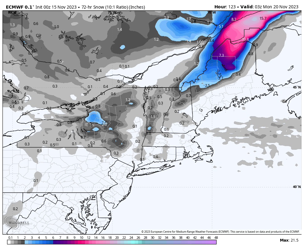
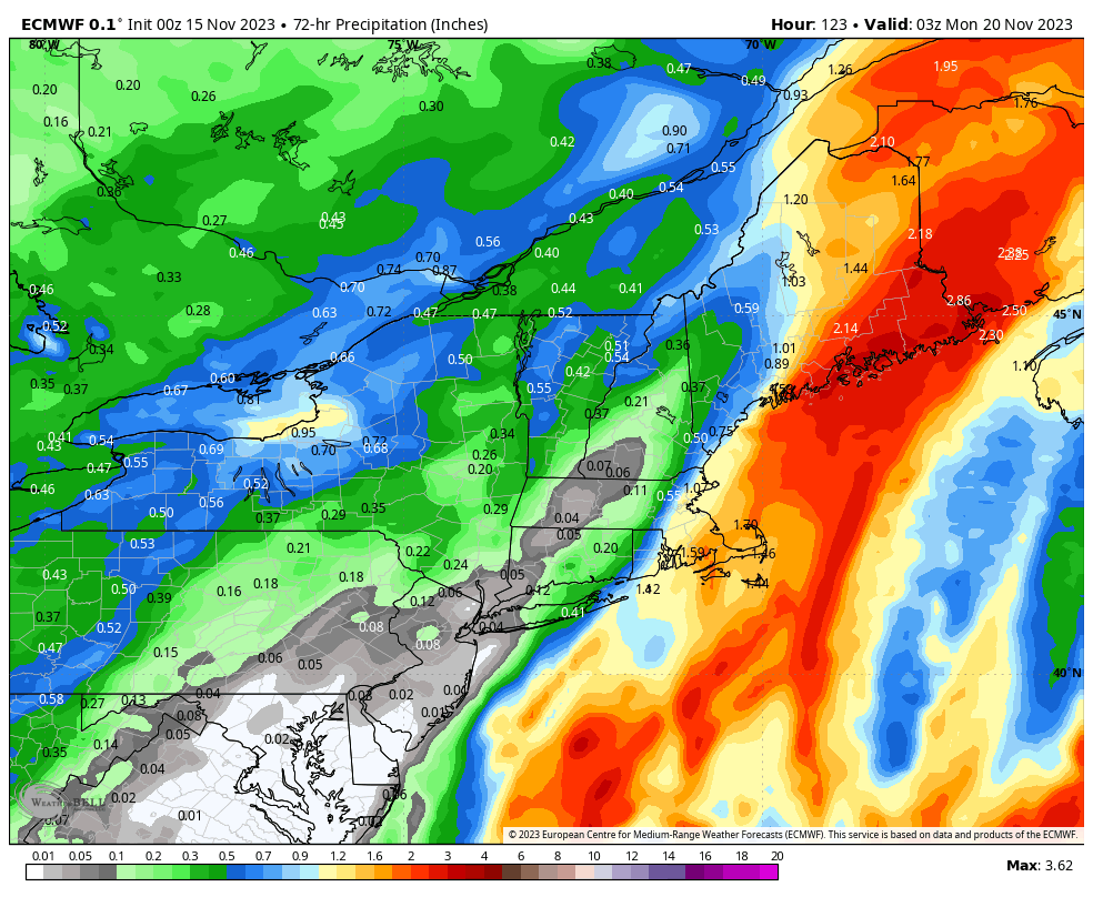
We have a mixture of rain and snow incoming, but I do not currently see substantial snow for any open ski areas. If the snow outlook improves then Sugarloaf followed by Sunday River would be the most likely to accumulate measurable amounts. Here's a slowed down close up view of what the ECMWF sees.
Saturday: Right now it looks like rain will clear Saint-Sauveur not long after midnight. Rain will taper off and switch to snow in Vermont in the afternoon, but elsewhere it will probably wait until after close. Rain looks light to moderate outside of Maine, but there is a risk of heavier rain impacting the Longfellows in Maine depending on how the storm evolves. I do not expect a large shift west, but there may be a dry slot between the front and the storm that favors Okemo and Loon more than others.
Sunday: There's a weak shortwave that will be moving southeast through the region and some light snow may make it to Vermont ski areas by the afternoon. Even light snow will notably help edge hold in icy conditions while it is falling.
Rain will be the primary type of precipitation. Unfortunately I'm not aware of a model source that separates rain from frozen precipitation, so first is just the snow and then the liquid equivalent of all precipitation including the snow. If you want to subtract the snow from the rain just move the decimal point left since snowfall is modeled at 10:1 ratios. These maps cover Friday through Sunday with the bulk of the precipitation falling during Saturday.
Temperatures
There's going to be a flash freeze sometime on Saturday, probably a little after midnight at Saint-Sauveur, and then the afternoon in Vermont, and after close further east. Sunday is expected to stay below freezing at all open ski areas. The two loops below show temperatures each day every 3 hours from 8 a.m. through 5 p.m.
Wind
Wind should not be a notable issue on Saturday. On Sunday wind might be an issue on the Longfellows in Maine, but primarily at Sugarloaf in the AM where I would estimate a moderate risk. I don't expect potential for wind issues elsewhere at this time. The two loops below show maximum wind gusts each day every 3 hours from 8 a.m. through 5 p.m.
Surface Conditions
As previously mentioned, newly opened trails on man made snow below freezing will be be hardpack at best, and with limited terrain trails get skied out quickly with not much traffic. Sharp edges are important for the early season. I can't stress enough how much of a difference very sharp edges make in the Northeast. Get yourself an edge sharpener and some training if you ski or ride frequently, and put a fresh edge on when conditions are frozen and your edges aren't super sharp.
Saturday: Saint-Sauveur might freeze and set up before open on Saturday allowing them to groom frozen surfaces (grooming unfrozen surfaces that then set up is something you want to avoid). Surfaces in Vermont look like they will start to freeze up from north to south starting around noon, while I don't currently expect others to the east to freeze up until around close. With the rain during Saturday conditions will be fun and edgeable until the freeze and then it will probably become extra technical for the remainder of the day.
Sunday: Thankfully everyone should freeze up well before grooming starts, and with limited terrain groomers can likely take more and slower passes in order to help break up the surface, but there is only so much that can be done following several warm days plus some rain. Sunday may be busier due to Saturday's rain, and trails will generally get skied off on blue and black terrain with all open ski areas expected to stay below freezing during the ski day.
Knowledge Is Powder!
-- Matt


Comments ()