I'm a little late in calling this a Storm Watch as confidence is already pretty high for this storm in the models and we have decent agreement now as of the 0z run, however widespread snow potential didn't look very good until this morning as models were still rather drunk yesterday and figuring things out. Presently precipitation is expected to start in the Northeast early on Tuesday and last through Wednesday. There is a good chance that some resorts will stay all snow and accumulate more than 6" in this storm.
Storm Updates will likely start Friday morning if notable amounts of snow still look likely. Updates will be issued daily until either the day of or the day before the storm. Storm Updates and will only be fully available to Premium Subscribers and will contain our own snowfall forecasting, precipitation type forecasting, wind hold maps and detailed coverage for how weather will affect operations at open ski areas with increasing detail and accuracy as we get closer to the event. Here's a 10 Day Free Trial for our premium coverage if you are still on the fence!
The Storm Will Be a "Triple Point Low"
The type of storm models are expecting is a "Triple Point Low" which can occur in the Northeast when a mature storm cuts through the Great Lakes and forms a new low off the coast with precipitation spanning between the two systems. This can also help keep cold air from being overrun by warm air being pushed north by the inland low. Typically this means some areas stay all snow, mostly north of the Albany, NY latitude in such storms, with snow changing to rain as you move south, and an elevation dependent storm nearer the changeover line.
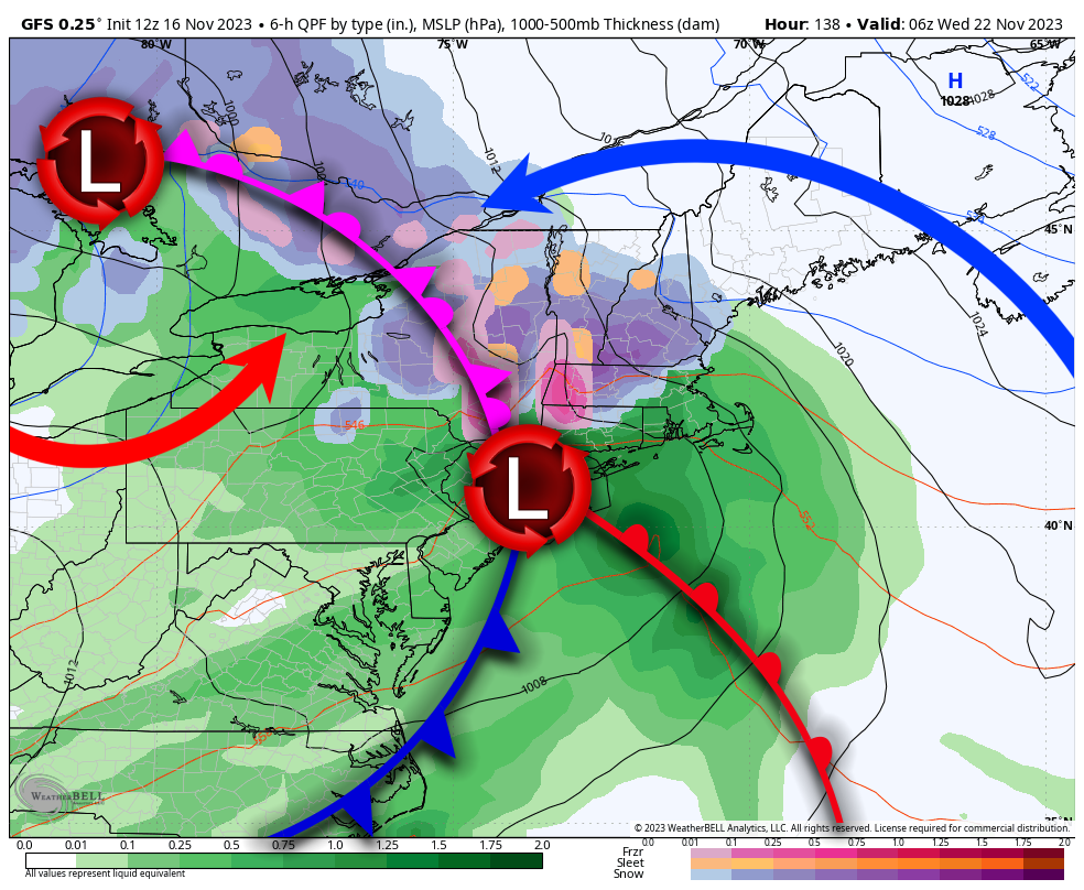
The "triple point" is the coastal low in this GFS precipitation map from this afternoon. There are three fronts all connected to that low with an occluded front spanning between the primary inland low that is cutting across the lakes and the secondary low that forms near the ocean. That secondary coastal low eventually breaks off and becomes a storm on its own, though typically not until it is exiting Maine.
This is different from a cutter that tracks through the Great Lakes and doesn't form a strong coastal secondary. We get warm southerly wind and rain from those. With the coastal low forming and becoming stronger, the entrenched cold air is given a boost and generally as it tracks towards the Northeast the cold wins out and keeps the precipitation as snow. Triple point lows generally result in snow in Northern New York and Northern New England with places to the south or nearer the coasts seeing snow change to rain or just rain. Temperatures are generally marginal with these systems and we see an elevation storm where mountains stay snow but the the valleys might flip to rain. Sleet and freezing rain in these storms is generally pretty brief and mostly ends as rain. Snowfall overall is rarely over a foot across a wide area since the coastal storm itself is competing with the inland low and unable to rapidly strengthen.
With Triple Point Lows you have to watch the southern edge for changes as you get closer to the impacts. What looks like all snow one day could end with a heap of rain the next day. Further north and northeast there is less concern and focusing on snowfall totals, wind, and driving is where your attention should be.
On a side note, this storm may well set the Northeast up for 10+ days of good snowmaking weather behind it, and that will likely also be covered in subsequent Snowmaking & Opening Updates which will contain some free and premium coverage together.
We've Been Watching This Storm for a Week
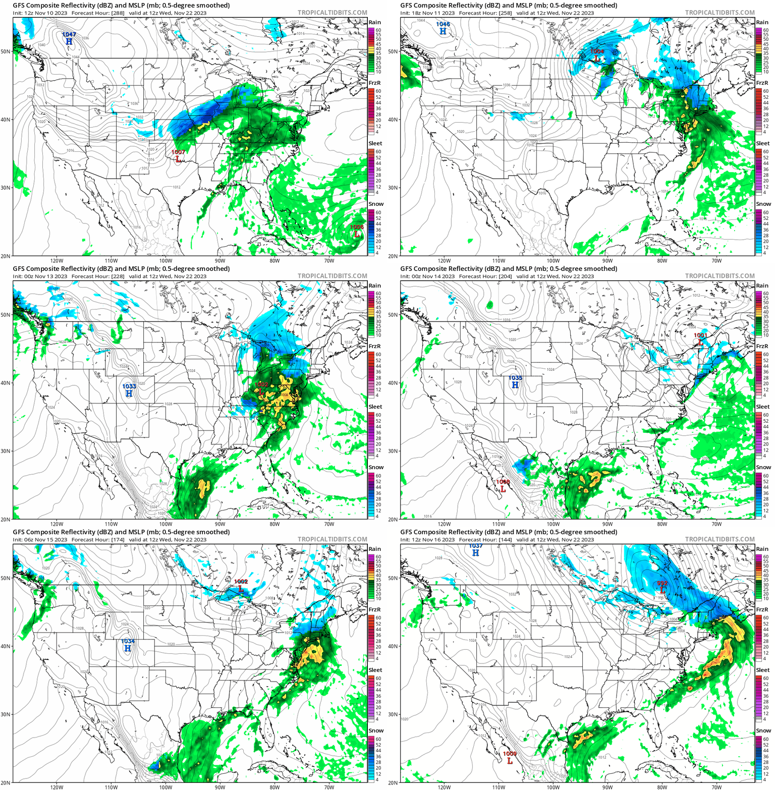
This is in fact the Thanksgiving day storm that some were starting to tease people with 10 days out, but you can pretty much assume that models 10 days out are as wrong as a broken clock. Let's look at what the GFS has been doing over the last 6 days of modeling in order to demonstrate why you wait until at least 8 days out. There are 25 different model runs in this loop, each showing what was modeled for 8 a.m. next Wednesday.
We can also take a closer look at the snowfall maps for the Northeast from the GFS over the same 6 day period, each showing what was modeled for snow depth changes (accumulating snowfall) through the following Friday.
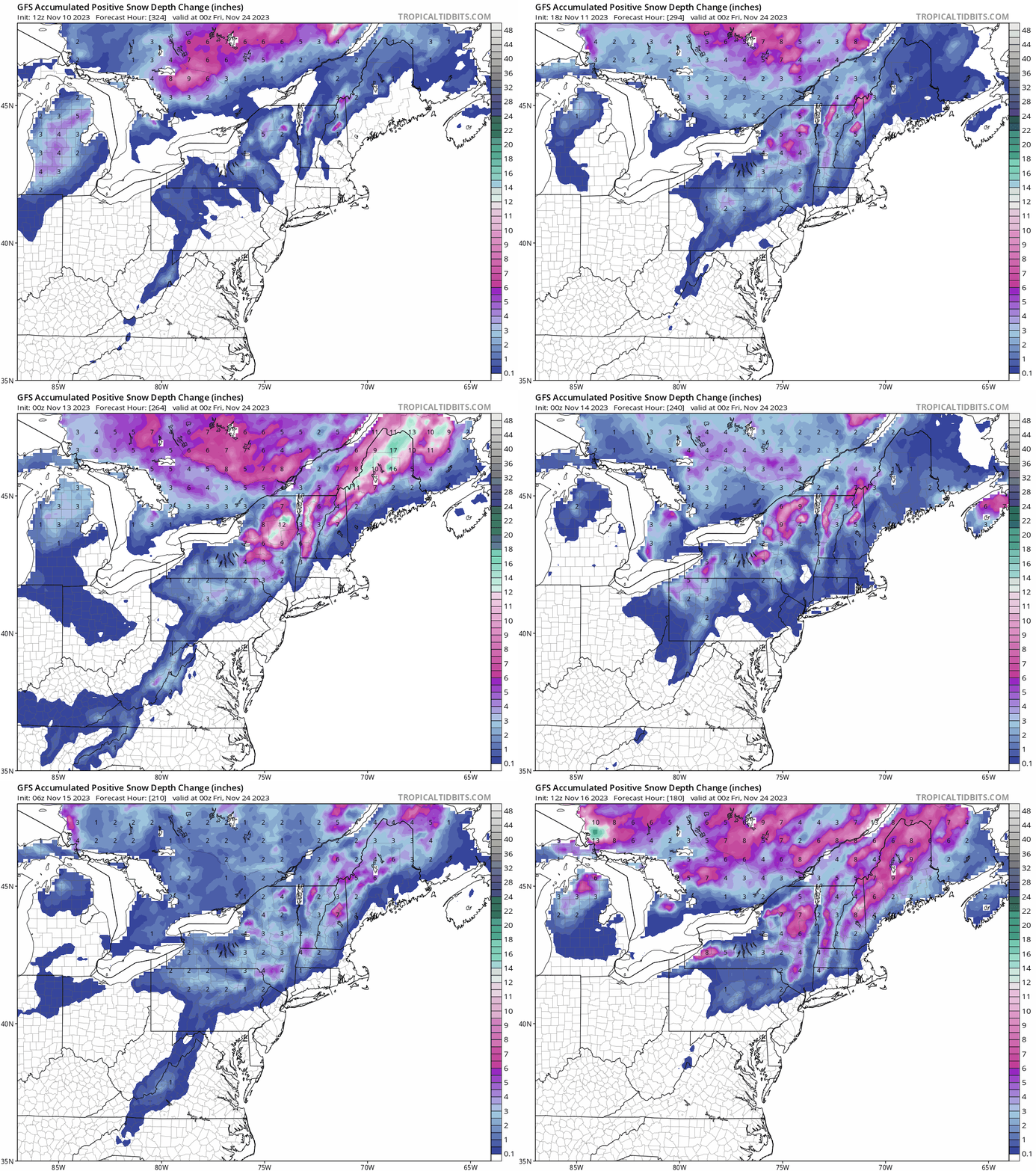
This is of course why you can't forecast snow in the Northeast until about 3 days out, and things will still shift every day.
I'll start detailed coverage of this storm for our Premium Subscribers tomorrow, and there's a decent chance of of a powder day at many open ski areas, though with limited terrain it will probably be more like a powder run and then a bump-fest. It is unlikely that this storm opens natural terrain at ski areas, though some will surely earn some turns on thin cover elsewhere.
Knowledge Is Powder!
-- Matt



Comments ()