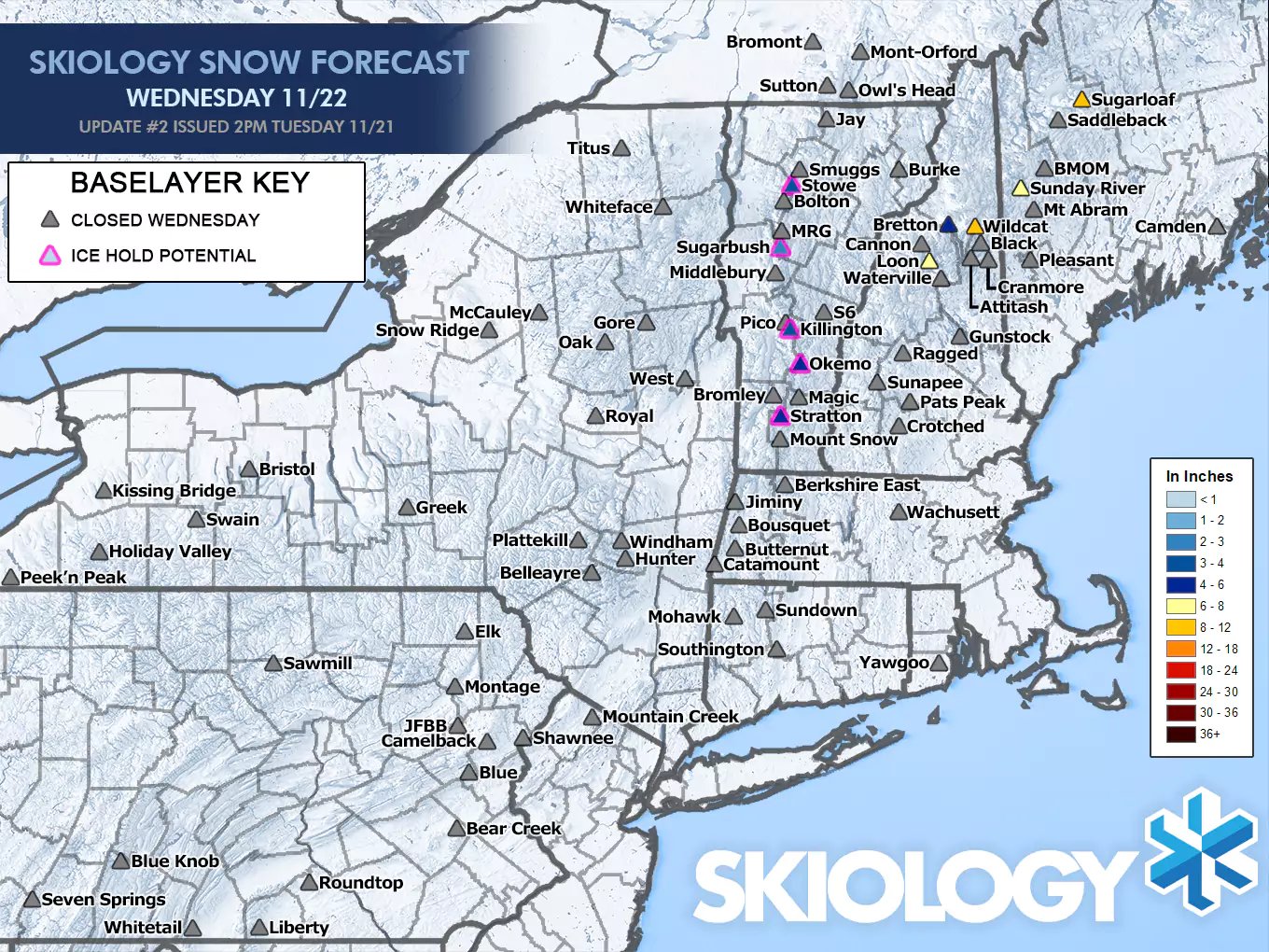
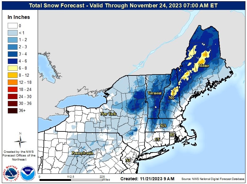
Snow is still tapering off at the Loaf but elsewhere the storm is essentially over. The only surprise from the last update was the trail end of the storm in the Whites and Longfellows stayed snow a bit longer than expected as the storm wrapped up closer to the coastal low and that slowed down more than expected the progression of warm air over Northern New Hampshire and Maine. Here's a look at some preliminary snowfall maps from NWS Burlington and NWS Portland/Gray, though the Gray map comes from 7 a.m. and didn't capture probably about 2"-4" of additional snow on the Longfellows. Note the NWS Albany office updated later than NWS Burlington and used a different tool for interpolation so snowfall amounts will not perfectly match.
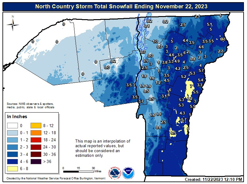
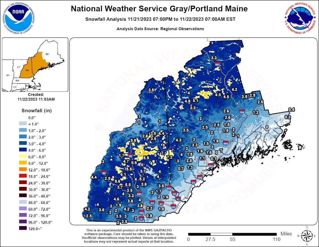
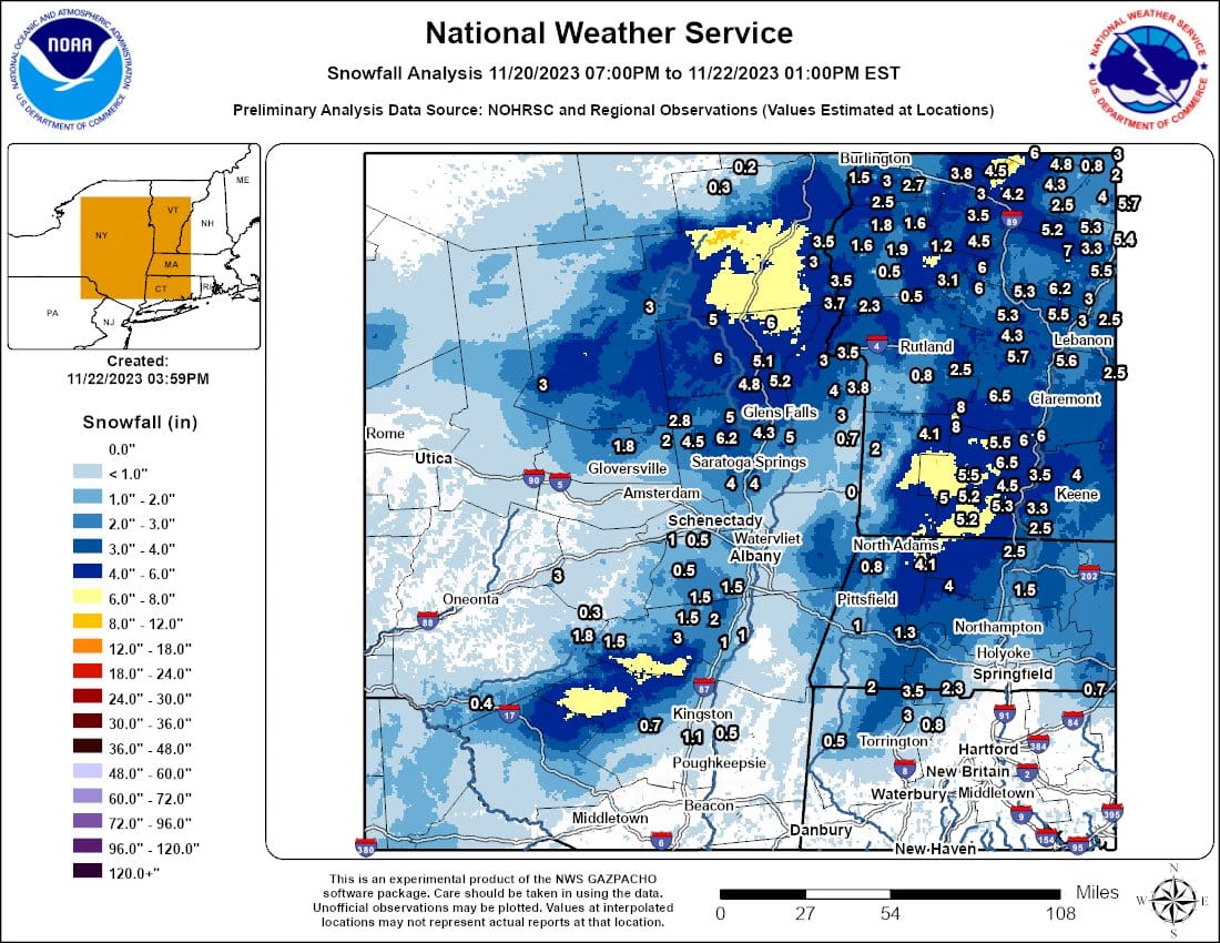
Preliminary NWS interpolated snowfall using ground reports to extrapolate surrounding areas with the help of terrain data.
Forecast Results
There wasn't a lot of disagreement between my forecast and the NWS forecast for this storm, especially since I only forecasted ski areas who would be open today. Snow reporting for the 11 ski areas (including Saint-Sauveur) are below the maps, however they did generally measure after compaction in VT and NY. Snowology's forecasts should represent what fell on the top 2/3 of lift-serviced terrain without drifting or compaction from rain, freezing rain, and sleet. This is essentially the NWS standard for measuring snowfall and what all forecasts seek to represent.
Here are the Snowology and NWS final forecasts prior to impacts:
Snowology's forecast on the left and the NWS forecast on the right.
The results from ski area snow reporting are as follows:
Sommet Saint-Sauveur: 6"
Stratton: 4" (settled measurement)
Okemo: 7"
Killington: 4" (settled measurement)
Sugarbush: 3" (settled measurement)
Stowe: 3" (settled measurement)
Loon: 5" (morning while snowing)
Bretton Woods: 4"
Wildcat: 6" (morning at base while snowing)
Sunday River: 7"
Sugarloaf: 8" (base measurement)
My only real miss for my forecast was Okemo coming in at 7" (confirmed on cam) which was above my 4"-6" range. The area around Magic was thought to be the hot spot in Vermont and they recorded 7" at the base with likely 9" at the summit for this sort of storm (not all snow more at the top). Wildcat and Sugarloaf definitely confirmed and both likely came in around 11" near the top despite the base measuring from both. Wildcat reported a range of 6-8 at the base at open, but it is standard in snow reporting for a range in a snow report to reflect the base as the lower number and the higher number being the top. They definitely reached into the 8"-12" range in the top 2/3 of lift-serviced terrain.
Snow did flip to rain or other non-snow frozen precipitation in New Hampshire by 11 a.m., and at Sunday River around 1 p.m., but did not flip to rain at Sugarloaf before tapering off. This was a bit delayed from my forecast, though not by a lot. Snow did mank up and become chundery everywhere with the warmer temps in the afternoon.
Ice and Wind Holds
I warned about ice hold potential at the 4 Vermont ski areas noting generally low confidence for ice hold warnings, and Okemo did suffer a delay for the Sunburst Six until 10 a.m. Stowe had a very short delay at open without specifying the source of the delay.
As far as winds go, only two ski areas were rated at 50% risk with specific chairs identified and both of those did go on wind hold. Stratton's gondola opened up at 11:30, and Sugarloaf's Timberline has not run at all today. I had the risk for Stratton's gondola from open to 11 a.m., and Timberline from open to 1 p.m., however it was noted that many ski areas who do not manage to open a lift by the afternoon will leave it closed regardless of the wind, especially on a not so busy day.
How to Properly Measure and Report Snow
I honestly have a very hard time doing storm postmortems in recent seasons given that snow reporting has generally gotten worse since 2020. I'm not sure if I will continue manually sampling ski areas and individual reports as I stopped last season due to widespread inconsistencies. The reporting for this storm wasn't bad overall however but definitely had some shortcomings.
Issues with settling are unavoidable and understandable when it occurs overnight due to other types of precipitation or warmth and there is no snow stake webcam with a history, but there has been generally more under-measuring, base-only measuring, and non-reporting now than there has been exaggerating in recent seasons, which is strange.
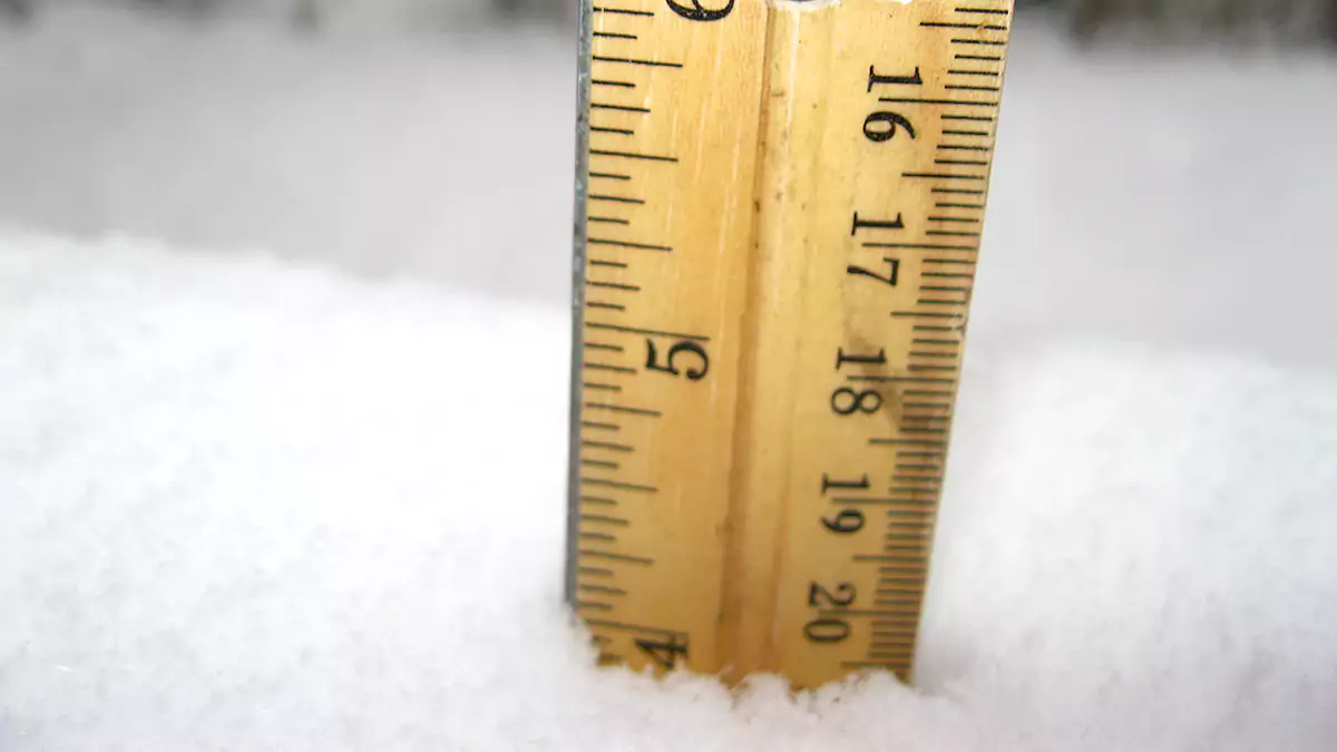
Optimally measuring snow should be done in a single standard location near the top and bottom of the mountain, or an average of non-drifted snow in multiple locations in the top 2/3 of the mountain and the base. It is OK to round up from 1/2", but not less. If a ski area reports a second time in the afternoon it should be a full measurement and rounded once for the full day (those who report twice and round up from any fraction will over-report up to 1 1/2" per day). Snow should never be measured in drifts or snow catches from buildings or terrain, and snow stakes should be wind protected with evergreens or fencing that block wind but not snow. Multiple whiteboards on the snow surface averaged together will average out drifting in windy conditions. Cams for snow stakes are a very nice touch and makes it easier to ski area communications to report. Pretty simple, although getting top measurements at open without a snow stake webcam is often not possible or easy without involving ops, ski patrol and may be eyeballed at times or inconsistently reported by a range of staff using different techniques.
When a range is reported, the lower number should represent the base and the higher number the top 2/3 of the mountain. The top 2/3 of the mountain measurement is what should be reported for a storm total and seasonal totals.
The most notable issue involving exaggerated snowfall totals is the result of cherry-picking. This isn't very common these days, but it does still happen. Taking multiple measurements all over and then choosing the top amount will dramatically inflate actual snow totals daily and over time in seasonal totals. If multiple measurements are taken they should be averaged for both the top 2/3 and the base. As an example, you could measure a flat field and find variability within that field due to subtle drifting, but if you found a low measurement of 8" and a high measurement of 12", the whole field really received 10" of snow and not 12". You want to measure what fell and not what drifted in order to be compatible with how all forecasting is done.
Knowledge Is Powder!
-- Matt


Comments ()