Sorry for putting this off, but with surprise snow in New York and Vermont did involve current operations and I didn't want to stack everything up. Simply put, this storm is primarily affecting ski areas who have not yet opened for the season. Then I had to rewrite the entire article due to age, and then I decided to shorten it... so here we go.
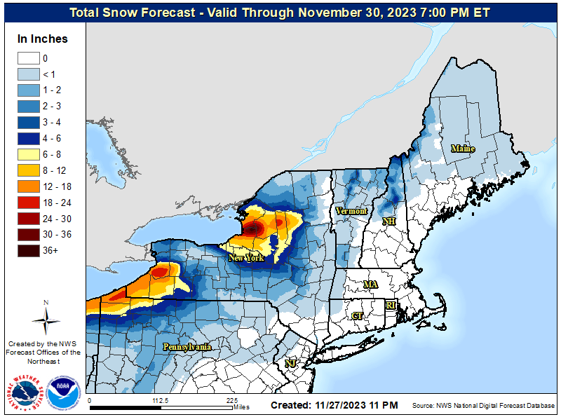
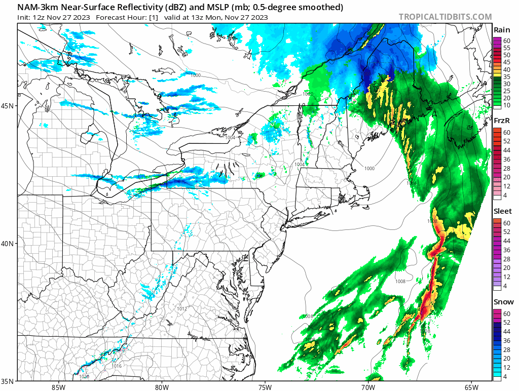
Forecasts for this event showed is potential for up to 18" off of Lake Erie, and over 24" off of Lake Ontario, and there are 5 ski areas that have a pretty good shot of landing in the 12"-24" range, though none of them are open... just yet. There are also some opportunities in Vermont and the Eastern Townships to take advantage of this. I'm going to cover first the ski areas off the Great Lakes, and then the effects in Vermont and the Eastern Townships, and then I'll talk about how lake effect snow is forecasted. Here's last night's NWS forecast map showing most of the event just to get the ball rolling.
There are other impacts that I won't break out. The area from Killington to Sugarbush could be getting some beneficial snow off of Lake Ontario, there will be some streamers helping in CNY and the Catskills, and some back end snow will reach places like Cannon and Bretton Woods also. Probably nothing to write home about given the current overall circumstances, but all snow is good snow of course.
Great Lakes Effects
The most important thing to understand is that only Holiday Valley was preparing to open on Friday, December 1st, and they are still not 100% committed to that as weather this weekend is a concern for them according to their last update. It's still November and snowmaking puts down a much more tolerant surface for those warm-ups. Real snow doesn't hurt of course.
There are 5 ski areas (that we track) in the thick of this off of both lakes. Snow Ridge, McCauley, Kissing Bridge, Holiday Valley, and Peek'n Peak. I've spoken with two who are probably the top performers so far; Kissing Bridge and Snow Ridge.
Kissing Bridge has an estimated 18" of snow so far and they are also making snow at the same time, but there is virtually no chance of them opening for this storm even if it stacks up to double that. They typically try to get open by mid-December and trying to pull off an opening during a snow emergency is not in the cards, though if the weather continues to be good for them, this could get the season started well for them come mid-December.
I also talked with Snow Ridge and they are the only ones who might be able to pull something special off as they are a family run operation, but the stars still need to align for that to happen. Remember, it's more than just snow! They have received 24" of snow so far, and it ain't over!
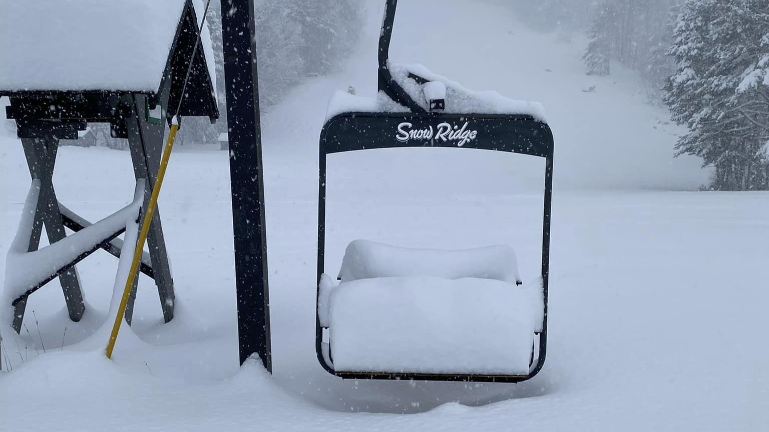
Snow Ridge shared that they have an inspection scheduled for their T-Bar on Thursday and if all goes to plan, they would have the capability, but they also need the weather to cooperate and they have to make sure that they could staff something like this. Right now you should definitely assume that they won't open, but if you are looking for deep lake effect pow from this storm, that's the only chance you will likely get. The good news is that models are now favoring a colder storm this Friday and Saturday that could add some more snow, but there is a warm up that is likely to have impacts on Friday.
McCauley is a municipal operation and I kind of doubt they would be able to rush an opening as their snowmaking just started. Peek'n Peak is further south and even warmer, and they aren't likely at all to open when the snow will be melting away.
There's more snow left to go, but snow alone doesn't open ski areas at this time of season.
Vermont and Eastern Townships Effects
It's kind of hit or miss with 2 more notable things to look out for. Jay Peak along with the Eastern Townships are going to open/reopen on Friday, and both Sutton and Owl's Head got dumped on in this last storm. The combination of some streamers sneaking along the northern edge of the ADK's can at times leave some decent snow in this area. From Monday afternoon through Thursday Jay Peak probably can pick up another 4"-8" of snow (probably conservative), and that would mean even more ropes dropping. It's probably fair to call that closer to 3"-6" at Sutton and Owl's head.
These are all closed now, but if you want some sleeper pow to go and hunt, you need to be eyeing these three ski areas on Friday, but there's a big BUT to look out for. It looks like Thursday these areas will warm above freezing and then freeze back up for Friday morning before warming above freezing again on Friday. If the snow doesn't cycle (melt and freeze) and it gets into the upper 30's on Friday, the flats will get sticky by Friday afternoon. Warm fresh pow creates a water bond with your bases, literally surface tension, and it can be brutal at times. Hopefully this will be enough of a cycle, though there might be a slight crust on untouched natural snow come Friday morning.
If you really are an expert at hunting opportunities for pow above freezing then you need to seek out who has cycled since the last snowfall! Even sun exposure can make a difference. Saturday these areas may get a touch up with fresh snow also. Let's hope we can see some natural terrain start to open in earnest.
Synopsis on This Event
To begin to understand this system let's take a look at a 6-hour precipitation intensity loop from Monday's 12z ECMWF covering from 2 p.m. Monday through 2 p.m. Thursday.
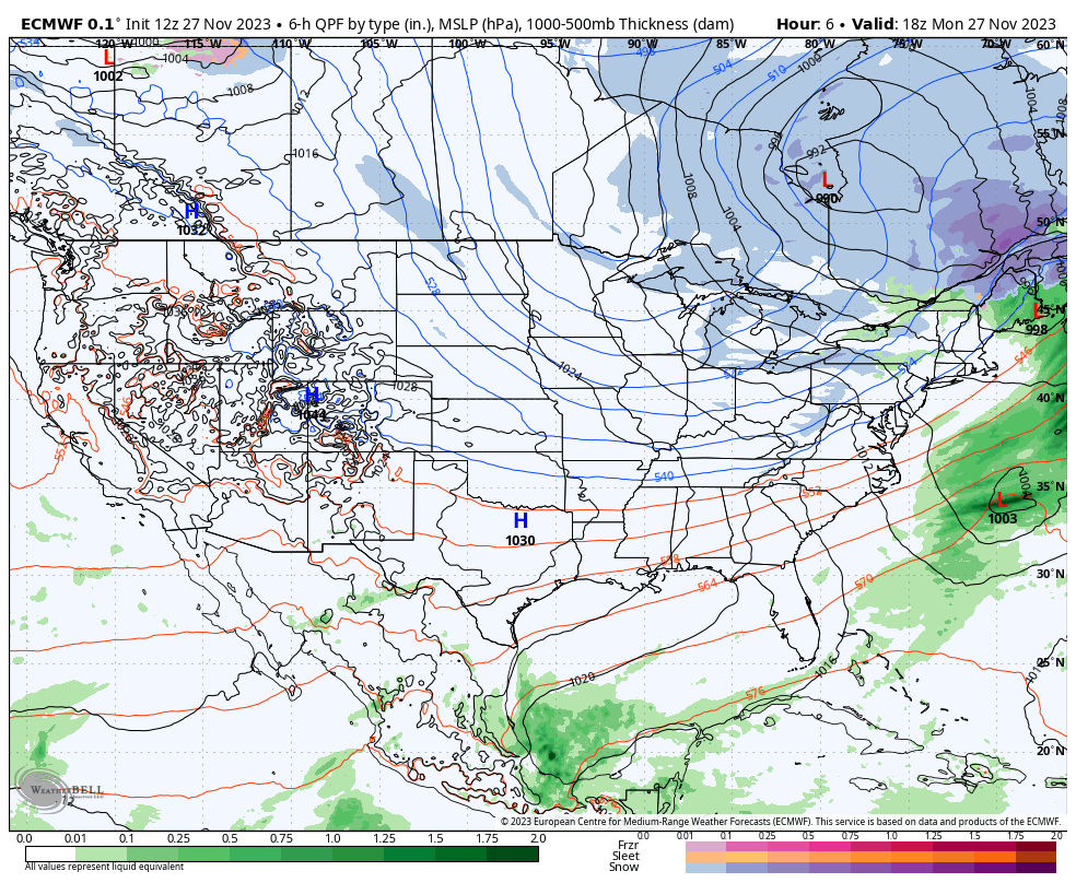
It's one of those classic Quebec lows that gets a little caught up for a bit then ending with a weak short wave around Thursday morning.
For a more detailed look let's break out the good old NAM3K simulated radar with a loop running from 8AM Monday through 8PM Wednesday. Focus on where those bands are pointed and how they change from hour to hour.
First, the beginning of this loop is pretty cool in how it practically steams off the lakes all at once. It's also pretty chaotic looking over multiple days makes this 3 day event impossible to pinpoint forecast solidly and that's been clear for some time.
Likely no model had/has these bands properly forecasted through Thursday because there will be subtle shifts in the wind direction from what is modeled now to 3 days from now and in between. Forecasts for these multi day events tend to be blurry. NWS Buffalo often favors the GEM (Canadian/CMC) model because other medium-range models lack the resolution for properly forecasting lake effect snow as well as upsloping snow, but the GEM detects lake effect strongly, sometimes too strongly though. The lower resolution of this model also kind of spreads the snow out instead of trying to focus it into bands like mesoscale models with high resolution do. Case in point, here's a comparison of the CMC and the NAM3K for this event through Wednesday night.
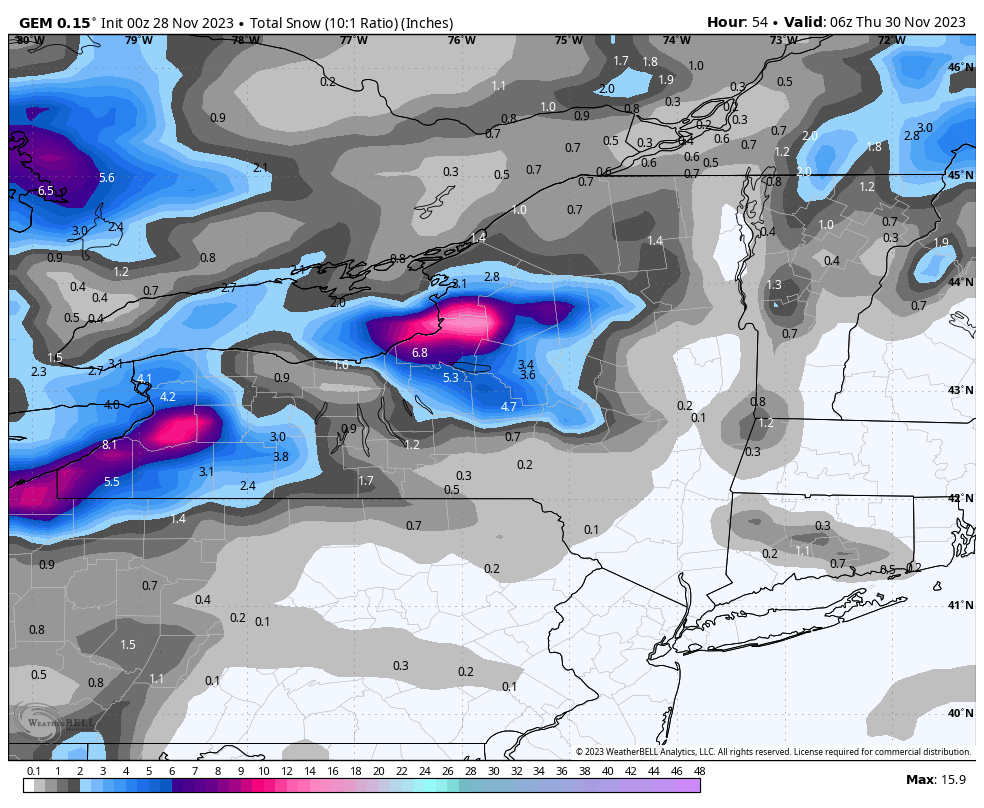
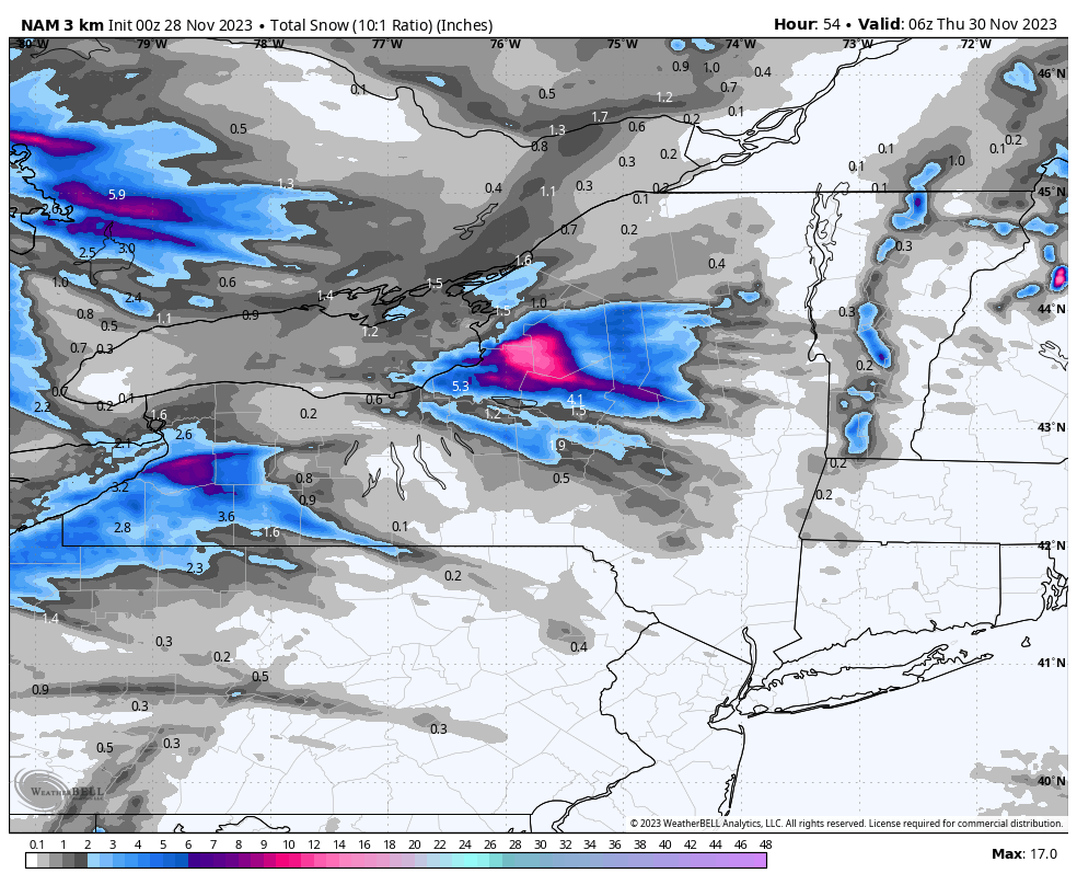
The actual snowfall distribution will probably look somewhat similar to the NAM3K in pattern (not the exact distribution), but if you want to appropriately introduce some variability, the GEM does that, and it also does a better job of predicting the top range for an event.
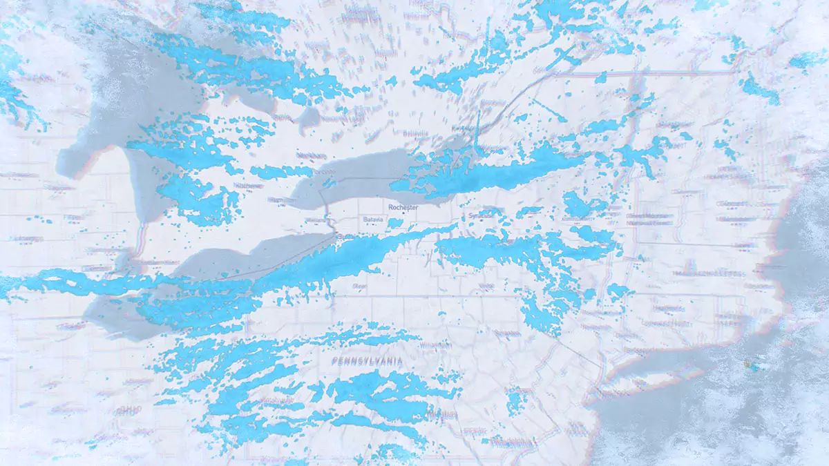
So here's the NWS snowfall map again for the entire region from 11PM Monday through 7PM Thursday. The forecast is largely GEM-based in the counties near the lakes. The Lake Erie distribution of snow has been shifting, but the modeling off of Lake Ontario into the Tug Hill and the Western ADK's has been much more consistent, and it's a notable firehose of snow when wind travels generally west to east.

The best way to read this map is sort of like probabilities. You need to expect with lake effect snow that there is some chance of upside, but more chance of coming in below the forecast. Those hot spots won't all fill in perfectly with snow and they may continue to drift from where they are modeled now. The NWS forecast is updated twice a day until it is over in order to keep up with small shifts, but at the same time losing the snow from earlier in the system.
It's just important to understand that lake effect snow is forecasted differently due to variability and hunting lake effect requires more than just knowing the forecast, you need to verify it is actually happening from radar, webcams, and social media since those bands can create copious amounts of snow just 10 miles away from a dusting.
Knowledge Is Powder!
-- Matt


Comments ()