We haven't been this lucky in the early season since 2018! When I issued a storm watch on Wednesday there was generally just weak support for a bigger and more widespread storm and our hopes were primarily for us to maybe put Northern New Hampshire and Maine into play for a decent dump. Over the last two days models have come into better agreement similar to the solution that I leaned towards, but with a lot more moisture. Medium-range models are now and largely are favoring a big dump starting Sunday afternoon and continuing through the end of Monday. There's also some potential late Monday and through Tuesday seeing some back-end effects boosted by some remnant moisture left behind in Quebec that could bring a nice additional pile on the upslope and maybe also off the lakes.
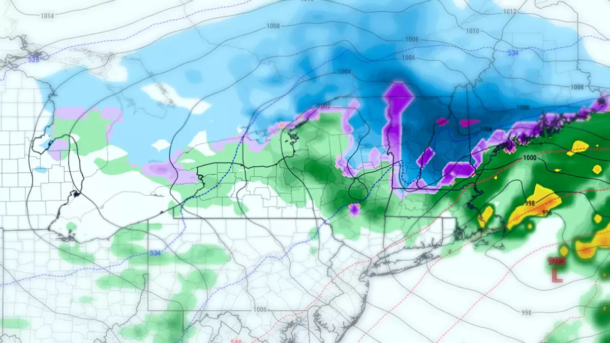
Let's start off with a wide view loop of the storm from Sunday through Tuesday evening as modeled by today's 12z GFS model run.
The primary storm is seen shortly after forming over Missouri and it tracks ENE just off the Great Lakes in New York. The secondary energy is a big feed of moisture from the Southeast which is streaming northeast just in front of the boundary. As the storm enters Northern New York it begins to transfer energy to a secondary low tracking along the Northeast coast. This will both reinforce the cold air ending most of the advance of the non-snow and then transfer moisture across New England to the coast while the inland low weakens.
We got lucky with the track of that primary low. It is further southeast than previously modeled and being closer to the ocean is all it takes to help the storm make the jump to the Atlantic where it prefers to be.
Model Agreement Better, But Not Yet Optimal
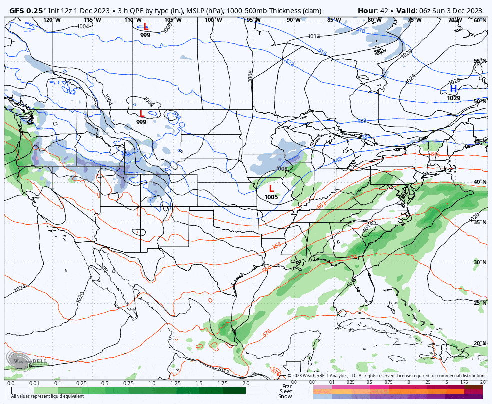
Run by run model agreement is getting better, but we are only about 48 hours out now from the start of snow. Typically we would be where we are now about 4 days out, but models have a very hard time with the timing of multiple shortwaves traveling along a boundary.
I'll skip the details of what is different since everyone is surely more interested in how much snow there may be, but I do have to make sure everyone is aware that as of this moment modeled snowfall is more variable than normal and snowfall forecasts are likely to change, and in some cases dramatically. Ensembles for all three medium-range models all favor a less snowy outcome, which gives me some pause. If you are planning on hunting this then understand that there is risk of some large shifts in both the models and my forecasts, and you should wait to see what I have to say on Saturday before making reservations, especially for NY and VT.
Precipitation
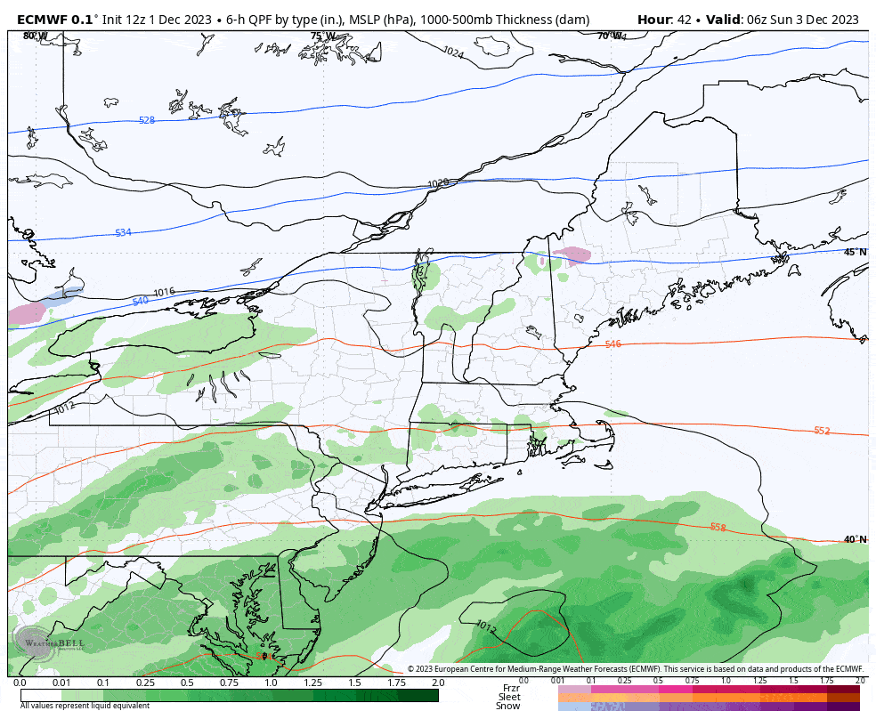
There will be a lot of rain on Sunday, that's for certain, and probably a lot of snow plus a little ice. South of the Albany, NY latitude (even with the northern MA border) we should generally see about 0.5" to 1.5" of rain on ski areas. North of that latitude we should generally see 6" to possibly 18" of snow. Let's take a regional look at what the ECMWF looks like from Sunday through 7PM on Tuesday.
Now let's take a look at the snowfall maps for Sunday through the end of Monday from the three major medium-range models. The deterministic models are in pretty good agreement despite seeing the storm develop and jump to the coast slightly differently. The GEM (Canadian) model has the latest jump to the coast of them all which is why the heaviest precipitation is further to the northeast than the others. There are speed and track differences between the ECMWF and GFS which don't show up in the snowfall maps, but those differences are yet another cause for pause.
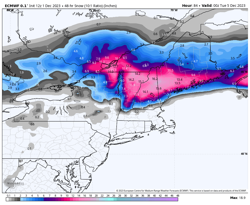
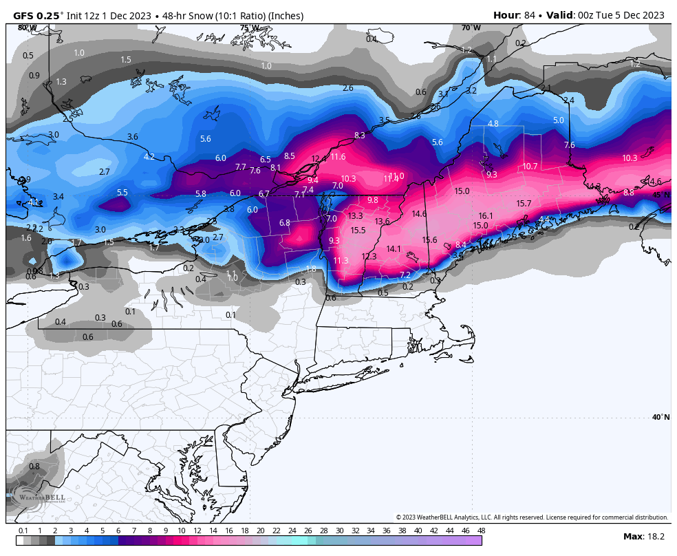
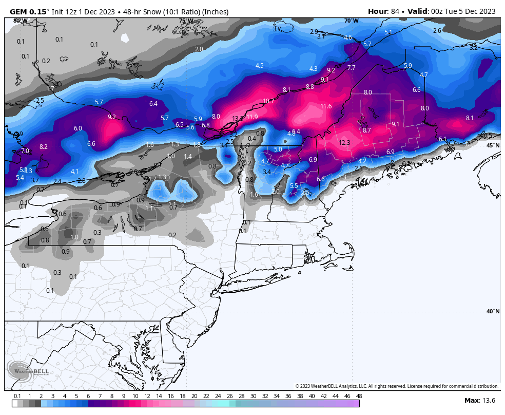
Since we are just 48 hours away from the start of the snow it is appropriate to put out my own forecast. I am definitely being conservative in the face of the models because I expect shifts. I am mostly concerned about NY and VT underperforming, but not necessarily to the extent of the GEM as is shown above. I will boost totals appropriately as confidence increases and also shift the focus of the snow, but for now I have put this mostly in line with the ECMWF and GFS snowfall distribution and I am more conservative in NY and VT than those models show since that is the warmer side of the storm. Primary precipitation types are also shown in the baselayer. Lastly, this only goes through Monday evening despite there being some additional back-end snow likely through Tuesday because that part of the storm is still 4 days out and even more variable. I'll likely expand the timeframe in one of the next two updates.
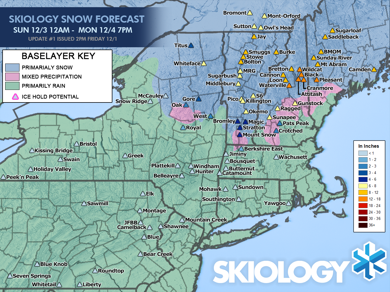
Now there is certainly potential for boosting totals in Vermont to over a foot probably from about Okemo to Jay Peak, but there is also potential to fall a little short of this forecast, so this is the best place to start. Confidence is highest around the Whites into Maine.
As far as the freezing rain potential goes, that is at the start of the storm primarily and will likely occur during the Sunday ski day. While it may not be pleasant to ski in, it is unlikely to cause any lift holds and should have no effect on Monday.
Wind
Good news on this front. I don't see any wind issues presently in the models. This isn't the type of storm that has strong focused winds. The highest winds seem to be around noon on Monday and focused on the Catskills and Berkshires, but not at levels that would likely threaten lifts. We'll keep our eyes on this, but widespread wind issues are highly unlikely at this stage.
Travel
The snow should start during the Sunday ski day, and roads may be slick in Northern New England for the drive home. If you are going to try to hunt this by driving up Sunday evening then you will experience some difficult travel, though Monday morning may be significantly worse depending on when the moderate and heavy snow tapers off. You'll want to have your snow tires on for this one, and Sunday evening would likely be the better call for when to leave instead of attempting a day trip through a notable storm on Monday morning.
Knowledge Is Powder!
-- Matt


Comments ()