This will be our final update for the storm. There have not been any large changes, but I have updated the snowfall map with both precipitation types and snowfall amounts, as well as all of the weather model graphics with ones from today's 12z runs. There are now some isolated wind hold issues on Monday. This is the same presentation as yesterday but fully updated.
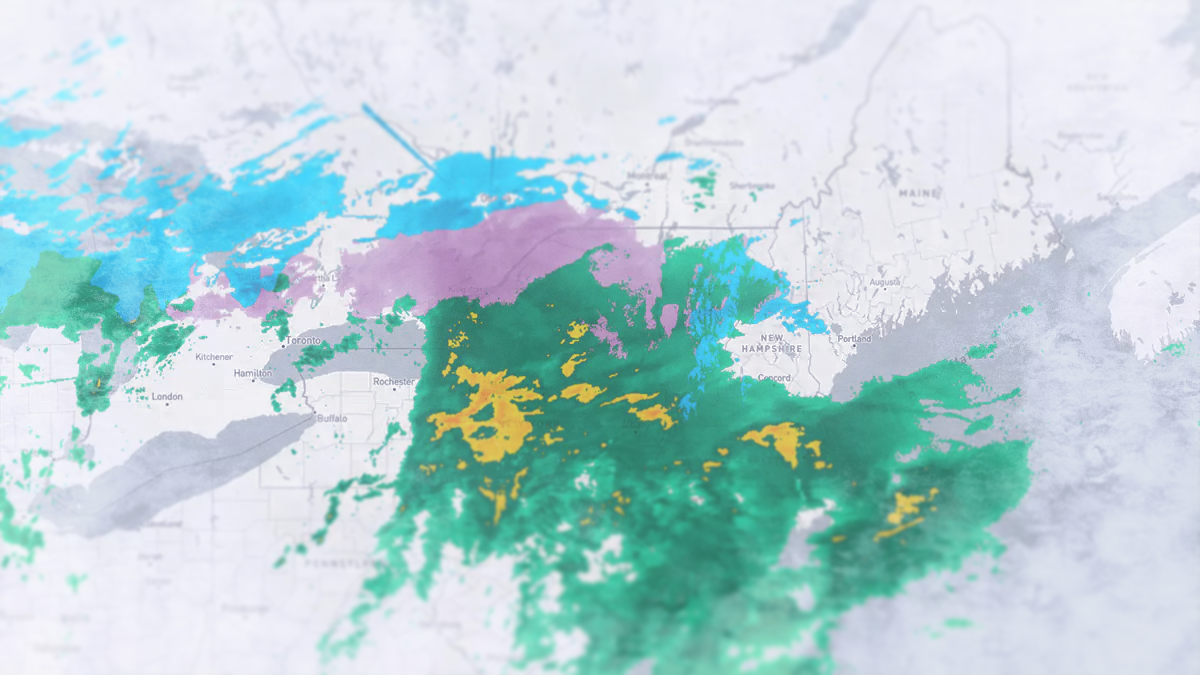
We'll start with the simulated radar view and some basic guidance before we get into the premium content. This loop covers all of Sunday from 8AM through Tuesday at 8AM.
Snow starts in earnest Sunday afternoon however all ski areas including Killington who are south of that latitude are at risk of mixing during the storm. We are and will see some extra rain at the start of precipitation before it flips to snow starting at the peaks and moving down. A burst of snow will start at 11AM today in the ADK's and Southern Greens and by 4PM moderate snow will have reached Sugarloaf in Maine.
Make sure to pay attention to midweek closures as there are approximately 10 ski areas who were open this weekend but will be closed midweek. Check snow reports or ticketing at ski area websites to confirm operations on Monday.
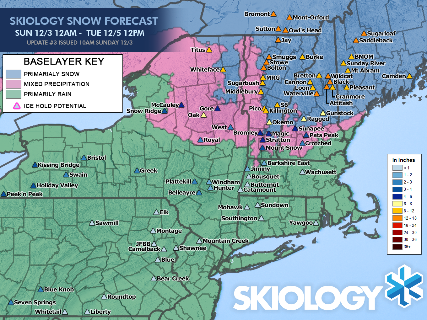
Snowfall Forecast & Precipitation Types
By close on Monday all but 3"-6" of the forecasted totals should have already fallen in the Northern regions with 1"-4" left in other areas. I'm now going to say that both Monday and Tuesday should be good days with different dynamics. Keep in mind that this forecast goes through Noon on Tuesday.
Here's the final version of our snow and precipitation type forecast map. Snow shown in NY outside of the Eastern ADK's is from back-end and lake effect on the trail end of the storm.
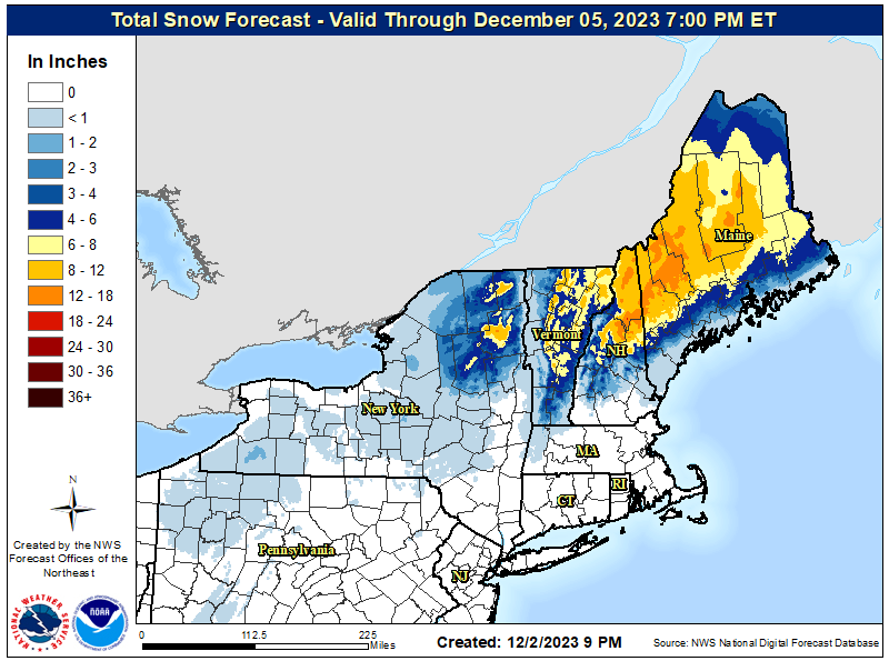
Here's a look at the NWS regional snowfall forecast through Wednesday morning. They trimmed in most cases, though NWS Burlington has now fully forecasted the trail end of the storm. My forecast overall is more slightly more bullish, but see places like Jay Peak, Smuggs, Stowe, Wildcat, Saddleback, and Sugarloaf likely reaching closer to 18" than 12".
Full depth won't happen until Tuesday morning. Tuesday morning may be a good time to hit the northern areas just to give you extra float above the frozen terrain. I expect about 3"-6" of additional snow to fall in the northern areas between Monday's close and Tuesday's open, and about 1"-4" elsewhere. Monday should be plenty fun though with free refills in the northern areas.
Confidence increases and variability decreases in forecasting as you get further away from changeover lines. I'm primarily concerned with what happens from the Killington latitude and south. Killington is likely a good bet, but not fully safe, and further south I would not recommend even if they might get lucky.
Here's a look at the temps from today at 8AM through Tuesday at 8AM. Pay close attention to how marginal temperatures are in Vermont through Monday. It can snow above freezing after the initial burst, but temperatures could affect snow ratios if they get too warm.

Wind Risk
The wind on Monday has shifted a bit further north and currently I would put Stratton's Gondola at a 50% chance of a wind hold all day Monday, however I do not except them to lose URSA so all terrain should be accessible at least.
Over at Mount Snow they have some wind risk until about 1PM on Monday. I would put the Bluebird Express at a 25% risk. Mount Snow's Challenger lift is at risk on the North Face, but they will likely open Outpost in its place given that Chute is now also open. I would put losing both North Face lifts at a 25% risk on Monday until 1PM.
Travel Issues
We are going to have some snowy roads both Sunday at close and Monday at open for both commutes. Temperatures on Sunday will be marginal for snow outside of the mountains so roads should mostly not accumulate. Heading up to Wildcat, Sunday River, or Sugarloaf on Monday morning may be extra difficult.
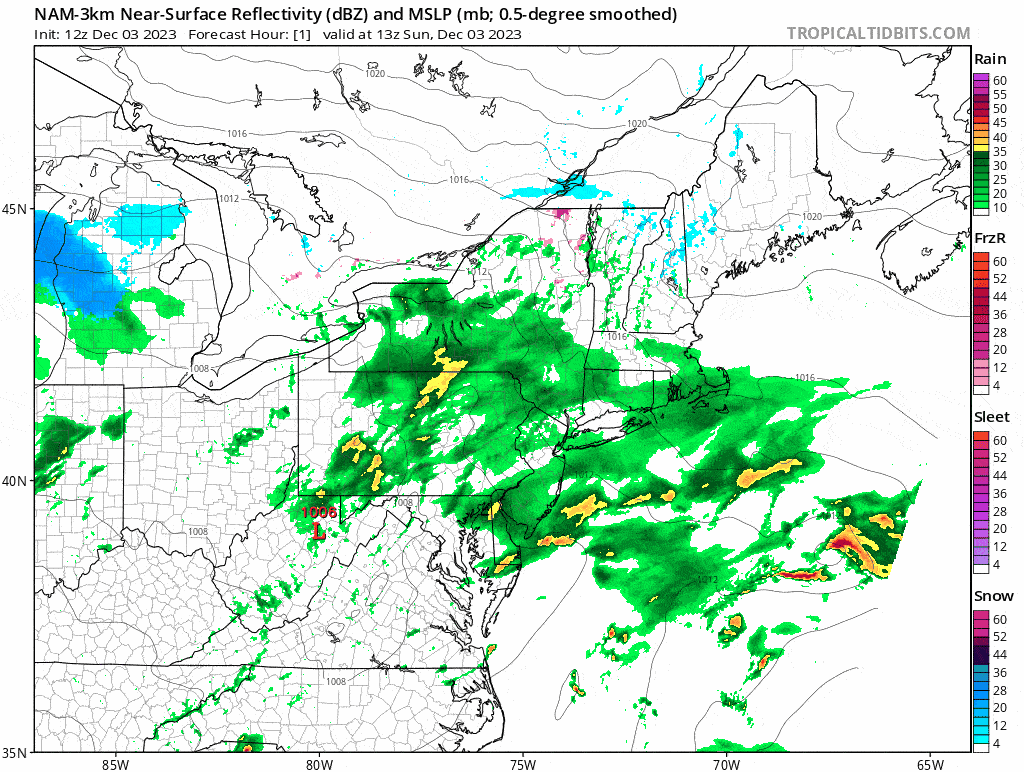
I'm showing three different 3-hour snowfall maps from today's 12z NAM3K to help you understand the driving challenges. The first shows snowfall 4PM-7PM on Sunday, the second shows 4AM-7AM on Monday, and the third shows 4PM-7PM Monday. These are all of the primary travel windows.
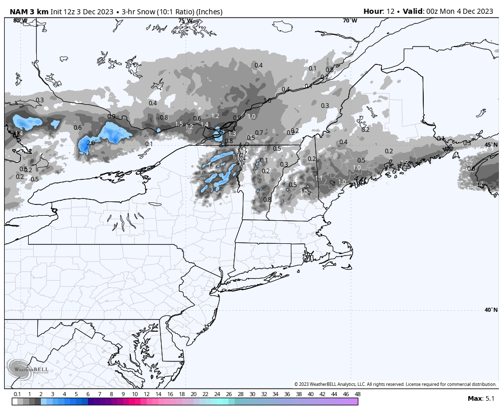
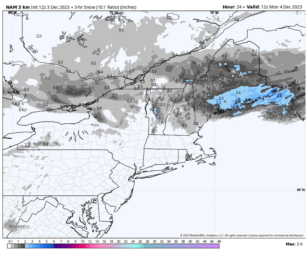
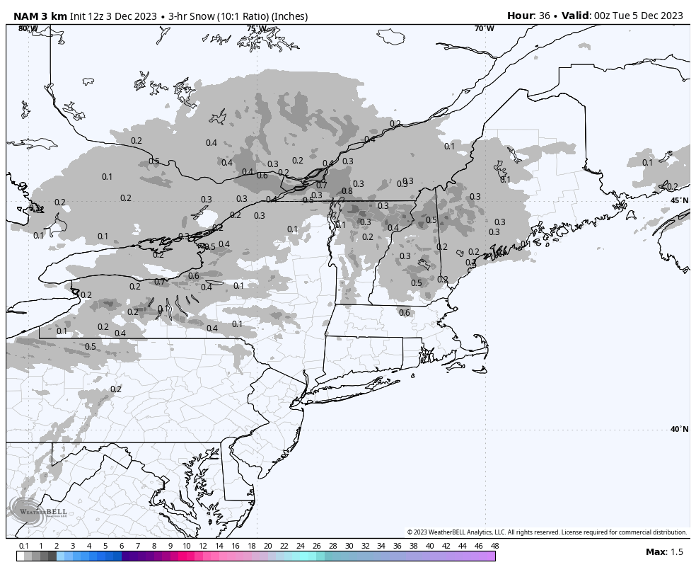
The way to read these maps is know that the blue areas are at least where moderate snowfall can be expected at rates of over 1/2" per hour, and sometimes heavy snow at rates of 1" per hour or more. Use extra caution in the blue areas and consider only traveling with a good snow tire or all weather (not all season) tire. The gray areas are generally light snow, though there can be bursts, especially from lake effect bands and snow squalls.
Knowledge Is Powder!
-- Matt


Comments ()