We have another 24+ hours of snow to go with this storm and it's a good time to do a little update on what has happened and what is still to come. Premium Subscribers will have access to the snowfall map from 8AM today through 8AM Tuesday and an update on wind holds and temps.
Let's first take a look at some of the storm totals reported this morning so far:
Bromont: 8"
Tremblant: 15"
Saint-Sauveur: 15"
Whiteface: 8"
Gore: 4"
Jay Peak: 9"
Burke: 10"
Smuggs: 6"
Stowe: 7"
Sugarbush: 8"
Killington: 7"
Okemo: 8"
Stratton: 4"
Mount Snow: 3"
Bretton Woods: 3"
Cannon: 8"
Loon: 8"
Wildcat: 12"
Waterville Valley: 9"
Attitash: 9"
Ragged: 4"
Sunapee: 2"
Sunday River: 12"
Sugarloaf: 10"
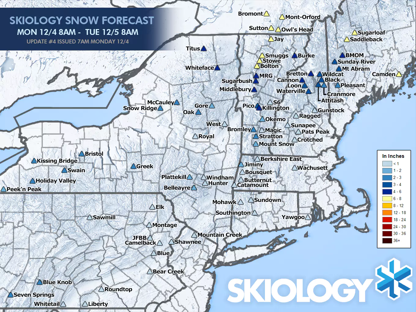
Our snowfall forecast is doing excellently with the mixing occurring up to about Gore in NY, south of Okemo in VT, south of Waterville Valley in NH, and no real mixing at Maine ski areas. Honestly, my forecast on this storm was about as good as I could hope for in every aspect. Some reports may be a little high and low of course and there is more to come mostly from the Killington latitude and north, though today will be spotty in some areas with things picking back up after close and through early Tuesday.
Here's a 24 hour simulated radar loop from the 6z NAM3K model that is slowed down and time stamped. Details on the snow, temperatures, and limited wind issues will appear below the paywall.
Snowfall: Plenty More Left to Go
There's about 3"-8" of snow still to come in parts of Northern New York, The Eastern Townships of Quebec, Vermont from Killington and north, Northern New Hampshire and much of Maine with some lower amounts expected elsewhere. The following map shows what to expect from 8AM today through 8AM Tuesday which should be virtually everything from this storm. These amounts can be added to the ones reported this morning by various ski areas, and they generally collect that information between 6AM and 8AM.
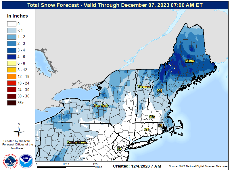
NWS also has their forecast from 7AM forward, but they are a bit more reserved than I am by about 1"-3" in general from around the Mount Snow latitude and north.
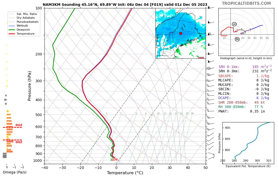
I expect this snow to be quite fluffy today in the northern areas. Likely ratios of 15:1 (snow depth to the water equivalent). The reason why I expect fluffy snow is because of how saturated the air is way, way up in the atmosphere, along with the light winds which will not shatter the flakes. 15:1 may in fact be conservative. Here's a look at the sounding which shows pretty good saturation up to about 20,000'. That allows flakes to grow for quite a while at the right temperatures to grow big crystals. This sounding is from 8PM around Sugarloaf.
So the difference between my forecast and the NWS forecast may simply come down to snow to water ratios.
Wind Holds
Models have backed off on the wind a bit and I don't see any real risk in the afternoon. We're talking about a 25% chance of Mount Snow losing Bluebird and also both lifts on the North Face. We're also talking a 25% chance of Stratton losing their gondola in the AM. Essentially the wind needs to overperform slightly for these to confirm. I have no other concerns about wind today.
Temperatures
We pulled off another miracle with snow falling at or above freezing in many parts. Today we're going to see many ski areas in New York and Vermont get above freezing which means manky snow in those areas. Temperatures are more accommodating to fluff in Northern New Hampshire and Maine where the snow is plentiful. The following loop runs from 8AM today through 8AM on Tuesday.
Knowledge Is Powder, and It's Waiting for You Today!
-- Matt


Comments ()