There's something big coming our way and it doesn't look good right now, however too many people are already writing this off and I'm here to tell you that there is reason for hope, but you'll probably get skunked regardless. It's only December, it's the Northeast, and that's how we roll.
We've gotten pretty lucky for weeks with a series of cold hits ending up in our favor and storms that managed to just stay cold enough to dump heavy snow on the Northern areas. I've seen similar types of systems to the incoming one turn out to be far less damaging and occasionally turn into something largely beneficial, so let's not totally lose hope here just yet, but we are running out of time. I put the chances of a snowy solution for at least the western part of the Northeast at about 25% right now. There's probably a 15% chance of a solution that is warm but much less rainy, and a 60% chance of a washout for much of the Northeast.
📣 Note: Premium Subscriber tips for next weekend are at the bottom of the article!
General Overview
Here's the basic setup. The storm moving onshore in the North Pacific will pull a trough down the Rockies where it will meet the warm moist Gulf air and fire up a new storm somewhere around Oklahoma. That storm intensifies and turns NNE and tracks across the Great Lakes. There are a host of variables that will occur depending on track, intensity, and potentially other pieces of energy not presently seen in the models. All three major medium-range models predict somewhere between 1.5" and 3" of rain in the warm sector of this storm followed by a flash freeze.
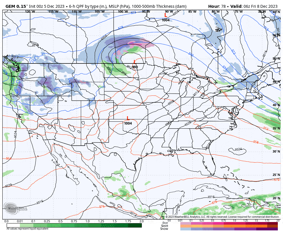
Here's a look at the GEM (Canadian) model's 6-hour precipitation intensity loop covering Friday through Monday. This is the least-amped model at present and the driest for the Northeast, and I believe at present the solution is the most plausible in terms of strength while the GFS and ECMWF are much stronger and wetter. It's still quite strong though.
Let's take a look at what all three models from their 0z runs show at present for Sunday evening.
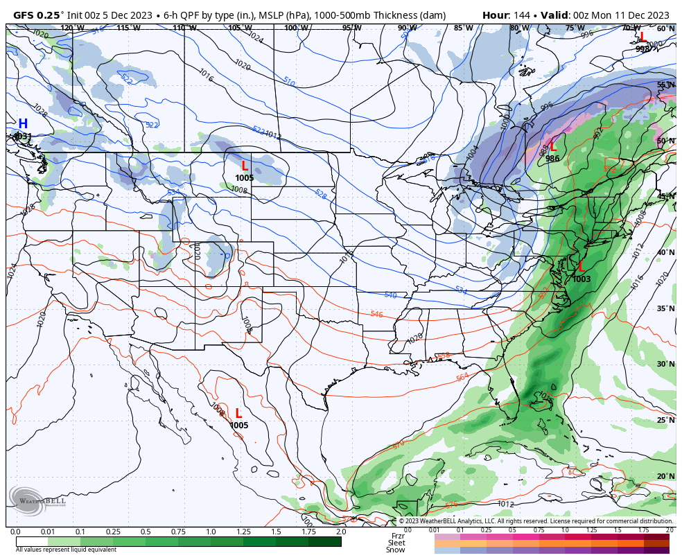
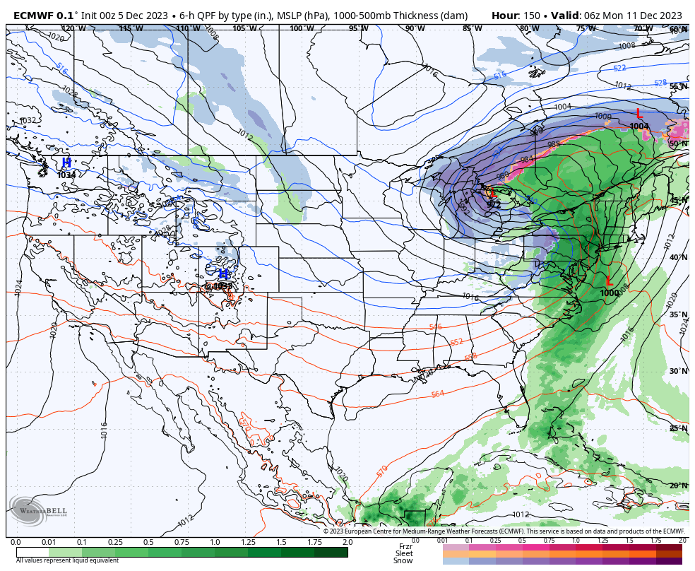
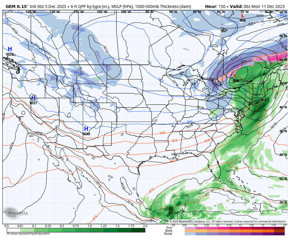
I would classify this as strong agreement, but being 5-6 days out there is certainly room to play. This system however is not super complex and doesn't involve meandering cut-off lows, chaotic split jet streams, or much more than one primary shortwave, so confidence for this range with this type of storm is higher than many others. Track and intensity will surely shift at least a little over the coming days and so will the other affects. I do wish this storm was a bit further east in the models right now because I would have a lot more hope for a positive shift.
Temperatures in addition to the rain are a concern. All three models show 50's reaching as far north as Quebec on Sunday during a window with heavy rain. Snow is likely to be best preserved in Northern New Hampshire and Northern Maine, while the snowpack in NY, VT, and near Montreal in Quebec could be dramatically harmed if this roughly confirms. Most natural snow terrain would probably be lost in those areas.
Very strong and even damaging winds are also presently modeled during the rainy part of the storm with strong winds also on the back-end. This could create widespread wind hold issues Sunday through Monday or Tuesday. That wind may however bring with it an extended lake effect snow event.
Reasons to Not Write This Off Just Yet
Generally when I see a storm starting to appear in the models along with rough agreement from 5+ days out, I don't like to see an optimal solution because it pretty much always changes in some way by the time impacts reach us. So a perfect looking storm 7 days out is likely not going to be perfect when it arrives. The opposite goes for a really bad scenario being signaled from so far out; they can get better. Right now this looks just about as bad as it could, so there's some hope 😄
Here are three ways that a storm modeled like this can end up being notably better than the apocalyptic scenario we presently see, but we have less than 48 hours to see a notable shift start to develop.
Scenario #1 - Swing and a Miss: If the storm moves even further west of us and tracks more strongly to the north, the rain would likely be much more muted in the Northeast. Sometimes when that happens the trough is still dug deep and a second storm forms and then tracks up the coast a day or two after the missed storm was going to hit us.
Scenario #2 - Strong Coastal Secondary: When storms mature past the 'T-Bone' phase of development, new strong coastal storms can form along the low level jet where the strong flow of moisture is. This is also more probable in weaker storms and a coastal secondary will help lock in the cold similar to the last two systems. It can also occur when the storms race north into Canada and break off from it's warm moisture tap.
Scenario #3 - A Change to a Coastal Track: - If the storm tracks close enough to the Atlantic it will want to want to form a secondary and jump to the coast. We need the storm to track about 300 miles more east of where presently modeled for this to occur. A smaller shift though could result in far western areas of the region receiving some plentiful snow. This is our best bet and the 6z GFS did shift favorably in this regard. If the storm tracks a bit further south or at least further east before turning north, we could get a coastal storm.
So what are the probabilities of a more snowy shift? Probably about 25% at this range, but part of that probability may only put the western edge of the Northeast in play. Ensembles are overall about 85% against a mostly snow solution in any part of the Northeast, so there's that, but ensemble probabilities are only the present probabilities of all of the members and do not tend to predict larger shifts well in advance like the one we want/need to see.
Premium Subscriber Tips
Knowledge Is Changing Up to Avoid a Washout!
-- Matt


Comments ()