Sunday River is opening their new Barker 6 bubble this weekend! 📷 Sunday River

Weekend Outlook: 12/9-10

We've had a glorious week filled with both fresh snow in northern areas and snowmaking has been happening widely across the Northeast with temperatures in many cases reaching optimal levels, but this weekend is going to bring change.

🚨
Forecast Maps Improved: After receiving a lot of great feedback on our new Ski Conditions Forecast maps, I've made improvements to all of our forecasts maps. Icons are now larger, text is more condensed, and the colors will now work for those with color blindness. I will also try to fit in more ski areas soon. There's a lot of information in one graphic, in fact I could almost do this entire update in just 3 graphics covering the entire weekend!

Saturday we get warm humid air in front of our next system that will cause some visibility issues and even some widespread fog which may cause travel issues as well as issues on some slopes, plus some sticky pow that will melt for the first time since it fell.

As you probably know by now we have a storm incoming on Sunday, but you may still be able to make a nearly full dry day out of it if you plan carefully, but you will also need to try to miss some sticky snow and also some wind.

We will get some snow behind this system on Monday and I'll issue a Storm Update early this afternoon to help you better understand what will happen. There will be snow with this storm, and also wind, but also a lot of rain. The storm will be both a boom and a bust.


PREMIUM CONTENT STARTS BELOW


Our forecasting, acitonable information, and tips are available exclusively to Premium Subscribers. It's only $29.99 for a full year and comes with perks like discounts on lift tickets and more.

Snowfall Forecast

❄️
The focus of the snow will be in the Alleghenies, Poconos, Hudson Highlands, Southern Berkshires and Boston Metro. It's not moving back north! Snow will fall at rates in excess of 2" per hour during Tuesday with most of the snow having falling in PA by open while filling in during the day in Southern New England. There will be a small back-end to this system to refresh parts of NY, VT, and NH.

We'll start off with the updated snowfall map. The snow shield has continued to condense, and as always there will be greater variability on the northern and southern edges of notable snow where a shift of just 25 miles with a storm so tight can either double or halve the amount of snow at a given location.

literally no two models agree and the NAM3K notoriously wobbles all over the place from run to run and when you have a mixing situation no other model lays a hand on it for precipitation types. I feel pretty good about this forecast except for one thing, how fluffy the snow is (SWE ratios). If I'm expecting 10:1 and it comes in at 8:1, it's still the same amount of water, but it will fall short of my estimates. I have about 6" for instance forecasted at Sugarbush and 6" forecasted at Okemo, but Okemo should get about double the amount of water in that snow and the difference is how fluffy it is. Ratios are a major factor in forecasting snow and it is not an exact science. They're literally still studying how to best calculate this.

After yesterday's update NWS offices pulled much closer in line with my forecast after bumping some, but unfortunately some areas took a turn for the worse and the NWS is now also trimming and they are generally below my own forecast once again. Here's the 5AM update from the NWS.

We'll see who gets this one right I guess, but I feel pretty good about my forecast as it stands. NWS offices are in at least some cases treating this as an elevation storm, and they forecast accumulating snow, some of which will melt and settle after falling on bare ground, but I forecast for the top 2/3 of ski areas for what falls on top of snowpack. Those are two different types of treatment, but mixing those two different treatments together is pretty difficult and gives me an edge by only forecasting for ski areas. I also make other sorts of manual adjustments; call them judgement calls.

Wind Hold Forecast

💨
We'll have some AM wind issues in parts of S-VT, S-NH, S-NY, NE-PA, and SW-PA with a handful of issues persisting into the afternoon. Wind looks stronger and more persistent than it did yesterday and the threats will last longer than our guidance yesterday. Times are given for each ski area warned for when the threat should end.

We'll start off with the forecast map, then there will be a loop showing gusts from 8AM through 4PM and then there will be a discussion regarding timing and scope.

This is a bit better than what it looked like from longer-range, but part of this is due to the fact that wind will increase through the ski day and keep increasing beyond it, so we're going to miss some of the worst winds.

Here's the loop showing wind gusts on Wednesday by hour. Every ski area is different based on many factors. Some can tolerate up to 50 mph as modeled here, while at the other extreme some can only tolerate up to 30 mph, but only from certain directions. Generally in Northern New England the danger zone though starts at 40mph.

Timing and Driving Windows

🚗
The leading edge of snow will will be strong and it will cause some travel issues Thursday evening in parts of New York and later into VT and the Berkshires. The Friday morning commute will primarily be a factor near the mountains in northern areas with some squalls remaining off the lakes in some intense bands of snow.

Here's a timestamped simulated radar from the NAM3K showing 7AM today through 7PM on Monday. This run shifted much warmer in Southern New England but I'm not completely buying that. The pinks and purples are freezing rain and sleet I don't really expect any freezing rain issues at open ski areas though, and sleet skis just fine, but it stings without something protecting your face is all.

Do not take the totals literally as this model overestimates snowfall on higher peaks especially above 15F. Treat this like a ratio.

I don't expect any issues in NY and VT at open, though Jay Peak starts getting into the danger zone shortly thereafter. NH and ME are a different story. Wildcat, Sunday River, and Sugarloaf are borderline in danger at about open and it will grow.


Knowledge Is Powder!

-- Matt

Saturday Forecast

☁️
Synopsis: Almost everyone will get above freezing on Saturday, and we'll have some sticky snow in parts of VT, NH, and ME. We will also be dealing with widespread fog and some mist on the mountains from southerly flow. Bring your clear lenses and maybe a goggle wipe!

Let's start out with the good stuff. It will be spring-like and comfortable for many to ski this Saturday if you pick 'em right, and I'll certainly give you all a heads up for what I am expecting. Terrain is building all over and we have a respectable amount of terrain now as well as more and more ski areas opening. For many, Saturday will be the best day for probably a couple of weeks, so make it happen! Here's the new and improved Ski Conditions Forecast for Saturday with the addition of a fog layer, and I'll discuss the highlights below.

🏆
My picks for Saturday are hands down Saddleback and Sugarloaf. Both received close to a foot and a half of snow last Monday, and Saddleback is opening 100% of their terrain on Friday. These are the only two ski areas that will stay below freezing on Saturday, or at least not get too melty to stick beyond their bases.

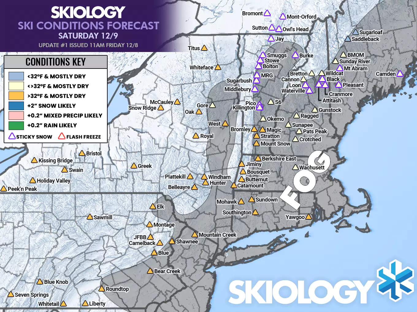
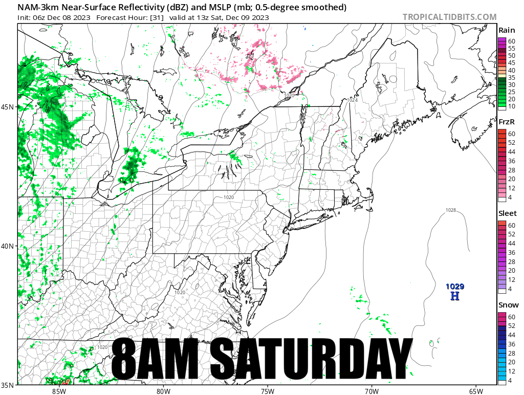
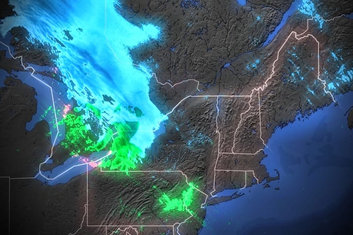
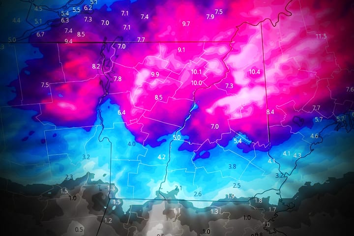
Although Saturday shouldn't be rainy, there is a heap of moisture flowing north with the southerlies out in front of this storm and that's going to create fog and even mist on the mountains, possibly even some freezing mist in parts of Maine. Let's take a quick look at the NAM3K simulated radar for Saturday, and pay close attention to those little green and pink specks. When you see that in this particular version of the NAM3K, that generally means fog and mist on the mountains. There's also going to be a ton of fog on the coastal plain through the entire Northeast. This might cause travel issues Saturday morning as well as ski issues when it comes to visibility.

The other concern will be the fact that a lot of the pow that fell since last Sunday has stayed below freezing and will first thaw early Saturday. Unfortunately that means sticky pow for some. Crayoning wax onto dry bases with a quick buff is one trick I use, but you can't always power your way through sticky snow. Hunting that deep powder from last week in some cases may be a mistake, but I'm sure many will try. I've highlighted ski areas in VT, NH, and ME where I have concerns based on whether or not the pow was substantial, and whether or not it cycled before now (melting and refreezing helps snow not become sticky).

Sunday Forecast

🌧️
Sunday is going to be tough. You may get in up to half a dry day in New England, but the wind will come before the rain so you have to pick your ski areas carefully. Maine is definitely the best call, though sticky snow will still be around and what was great Saturday may not be so great Sunday.

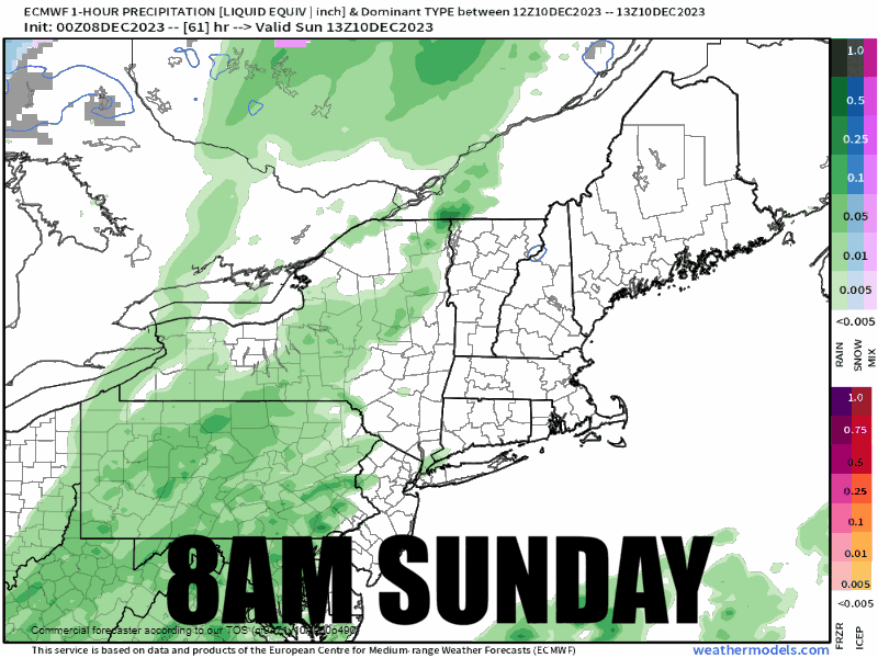
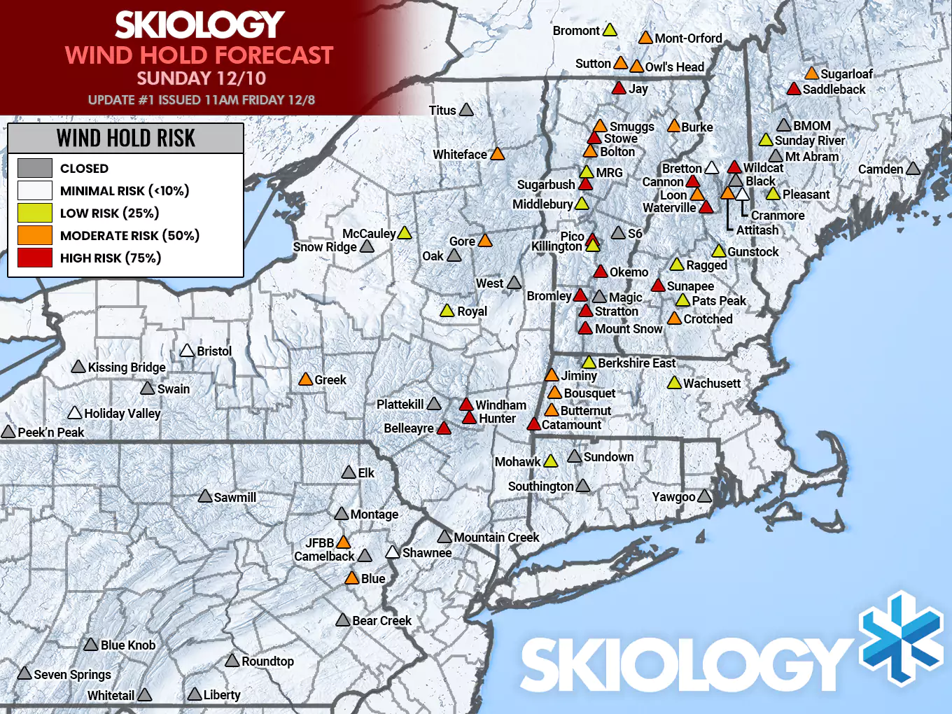
We'll dive right into the new Ski Conditions Forecast map for Sunday, but this time there is a baselayer which indicates when the rain will start. I've chosen today's 6z ECWMF for timing, and it is faster than some other models, so I would expect the arrival time to generally not be faster than shown, and they may be up to 2 hours later. No one is going to refreeze overnight and that means whoever was sticky on Saturday will likely be sticky again, but Saddleback and Sugarloaf are being added to the list as this will be their first thaw. It will likely be worse overall than Saturday in that regard. We also have wind to deal with and I'll discuss that separately.

🏆
My pick for Sunday is Sunday River as they will have the Barker 6 and the Jordan 8 operating, and those lifts can withstand winds about 10-15 mph stronger. They have the best shot of staying dry for most of the day and not having wind holds.

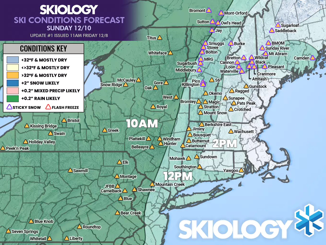
I have a loop of the 6z ECMWF also timestamped to go along with this so that you can visualize the progression of the rain. I expect a good number of ski areas in NY, NJ, PA, and maybe parts of Southern New England to not open on Sunday due to the combination of wind and rain.

So now for the wind. Wind will be lift-threatening about 2 hours ahead of the rain. So consult the map above for general timing. Wind hold forecasts confirm when a either a primary lift from the main base goes down for wind, or when other lifts are held for wind which limits or complicates access to 25% or more of open terrain for 2+ hours of the ski day. In this case don't expect many if any lifts to come back on line since it will probably be pouring rain when the wind lets up. I have some degree of warning out for almost every open ski area. The rain will make wind holds more likely so I've been somewhat aggressive. Expect many in NY, PA, CT, and MA to announce closing for Sunday, with maybe some others in Northern New England joining.

Knowledge Is Avoiding the Underdeveloped Powder and Wind!

-- Matt

🔒 SUBSCRIBER ONLY CONTENT

Snowology is more than just weather! We apply weather to operations and conditions for skiers and riders!

❄ Start a Free 10 Day Trial ❄

Already have an account?

×
×