Before I get into the storm coverage, I just want to recognize the tremendous enthusiasm and support that I have received from many of you in your comments and personal notes. Thank you! We're doing well thanks to you all and I think we're on to something big, though there is so much still ahead of us.
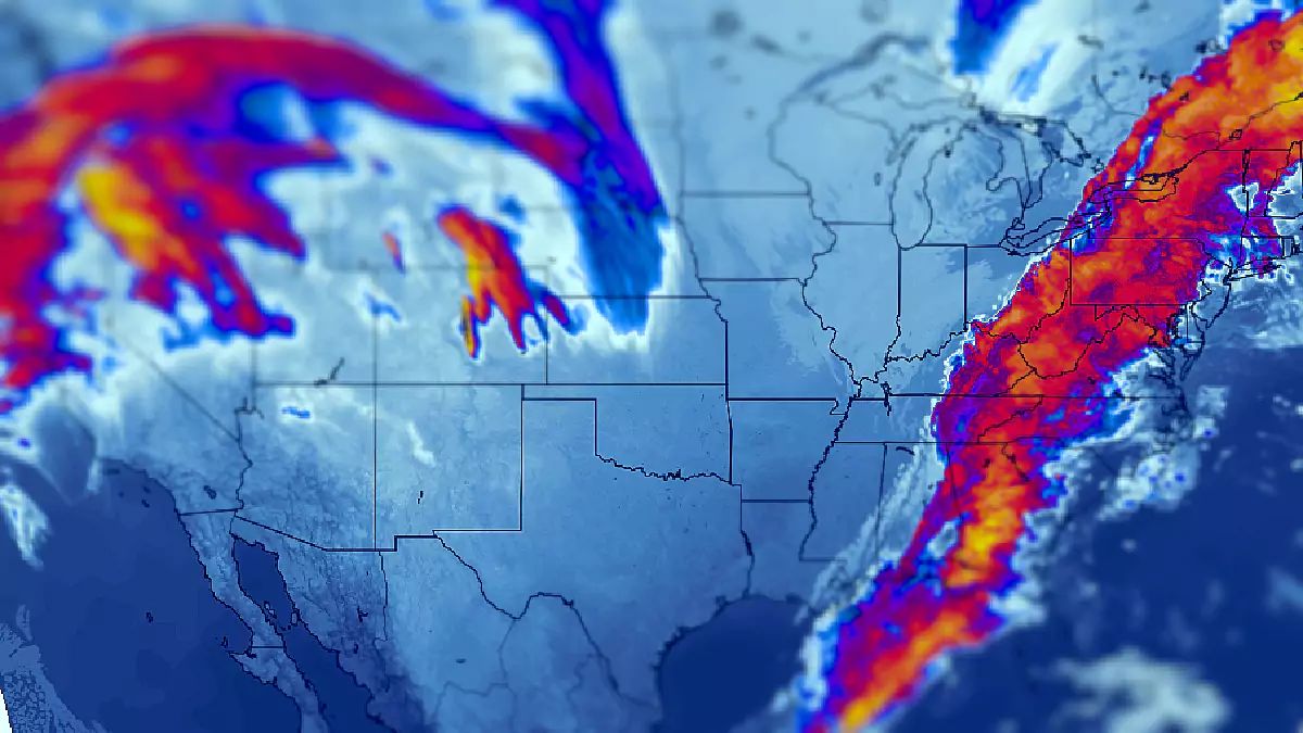
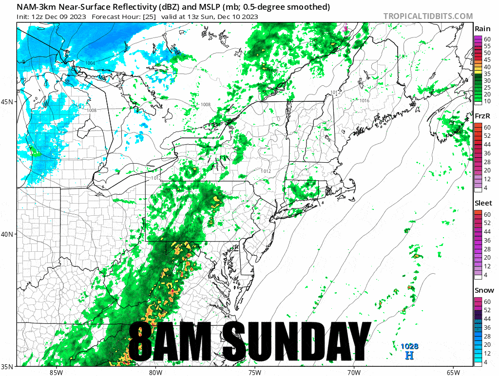
As far as the storm goes, we're mostly dialed in now on where the low will form and track with just some differences on strength at certain stages, though that matters a lot. I said the other day that a nor'easter was off the table, but this could in fact be called a nor'easter, a Miller Type-A as the trough digs all the way to the Gulf of Mexico with a storm center that may pass over Cape Cod. The non-nor'easter-ish thing is that it might not be that strong when it impacts the Southern New England coast. It's a very fast mover as well as a fast developer. Models are however generally favoring earlier development with more time over the water and that would mean a stronger storm and more snow! So let's take a look at the wide view of simulated radar covering all of Sunday and Monday from the 18z NAM3K.
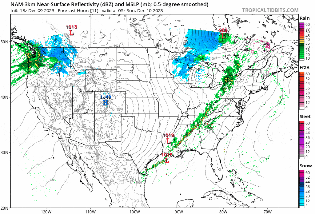
So last weekend everyone was talking about this nasty cutter and low and behold it's a fricken' nor'easter bub! I didn't predict this, but I did share that there was potential in our Storm Watch. Remember, models always change from 5+ days out generally in a sizeable enough way. So seeing a nor'easter at 6 days out is probably not as good as seeing a cutter since a nor'easter is unlikely to shift and change into another nor'easter. It's actually a pretty good rule of thumb in understanding the models.
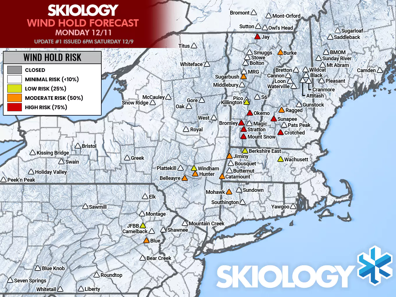
Wind modeling has changed dramatically due to how this storm develops, so there will be a lot of trims to the wind holds on Sunday, but Monday now looks to present widespread challenges in New England due to a coastal low forming and strengthening.
A Note About Driving In This Storm
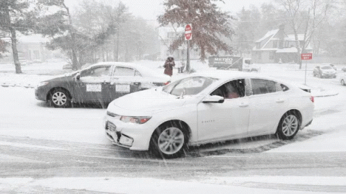
I want to stress that I strongly advise you all to not drive on Monday morning into this storm to hunt it. Snow will be falling at tremendous rates in the morning and and roads will be awful. The areas that will see the deepest snow likely start switching over around midnight Monday morning and it should go on for 24 hours. You'll want great snow tires for a storm like this, and even that won't make it a good call to drive Monday morning from far away. Driving back Monday evening will also suck in the hardest hit areas, so don't do that either is my advice.
I'm going to update our snowfall map, our wind hold map for Sunday, and issue our first wind hold map for Monday. There will be a timestamped simulated radar for Sunday and then all day Monday. Rain will also be a feature as that will be impactful to ski areas. The discussion will be much shorter and more deterministic at this stage because confidence is increasing and it's time to plan if you are looking for some freshies.
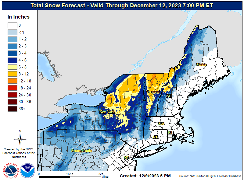
Let's Start with the Snowfall Map!
Models primarily disagree still about which of the multiple lows along the boundary becomes dominant and whether or not they combine. Models have a very hard time with lows on boundaries like this as I've indicated before.
I've bumped all around with greater confidence, but there's still plenty of upside and also some downside. This is a difficult storm to forecast. Also, due to the amount of rain that falls first, 6" of snow will not feel like a powder day. You'll want at least 8". The northernmost parts of New England will snow after close on Monday also, so don't expect full depth at close where you see those 12"-18" totals, and the storm will be dumping hard on those areas all during the ski day. It will be blinding with snow at times.
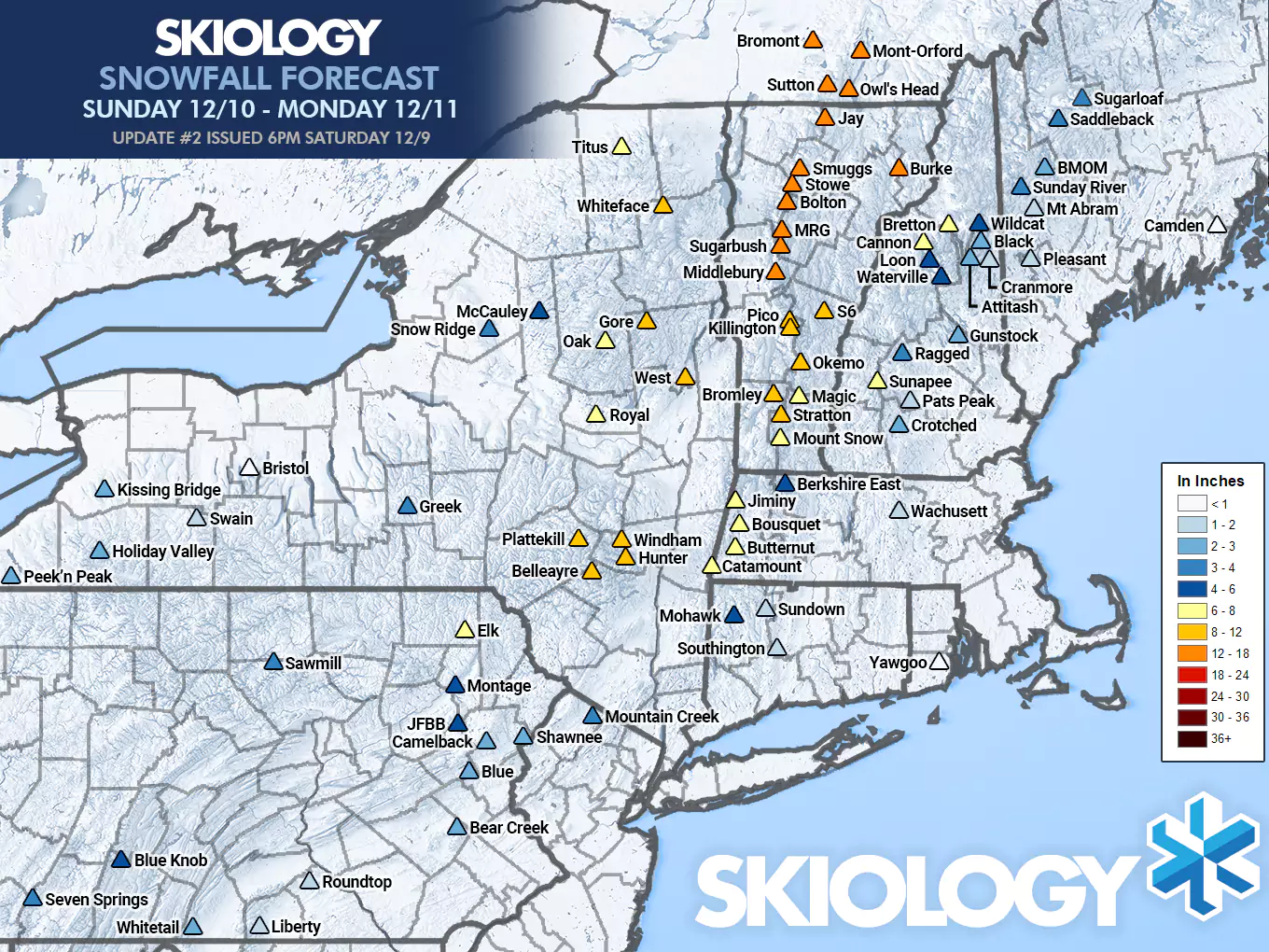
It's important to understand that my confidence isn't strong on all areas from 8"-12" and below. Some of these could increase by 50% and decrease by 50%, and all of NH and ME are question marks and could go either way with the trend favoring more in the Whites and Longfellows if it continues. Keep your eyes on Southern Vermont, the Berkshires and the Catskills for overperformance, and for that matter the Poconos could also overperform. I can see some ski areas potentially breaking 2 feet with this storm in Northern Vermont and the Eastern Townships. It seems to be one of those types of storms that models are constantly catching up to and the shifts have all been generally positive so far. It still has bust potential for this forecast based on some modeling, but I'm dismissing it based on support and not optimism. It's acting like a nor'easter and I'm buying into that line of thought.
Here's what the NWS has as of this evening and I'm actually going to look for the first time after this period and feed you my reaction.
It's conservative overall. I'm pretty sure they are much too strong off of both lakes because the storm is shifting east. I'm pretty confident they are too weak in Northern Vermont, the Catskills, and the Berkshires, and I was pretty conservative in the more southern areas but there is 1 foot potential on the high end in the Catskills and Berkshires and this forecast would be the lower end of probabilities. NH and ME are pretty close to my current thoughts with a bit of an eastward shift still emerging. They are clearly more NAM and GFS based in in this forecast for most of the region like I am.
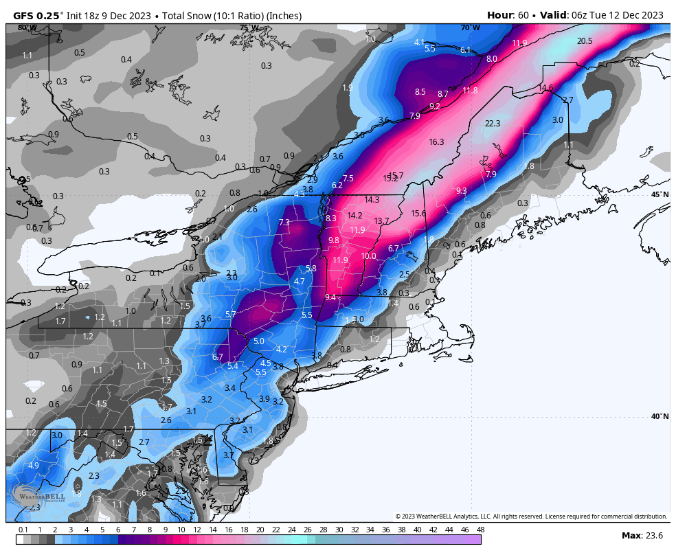
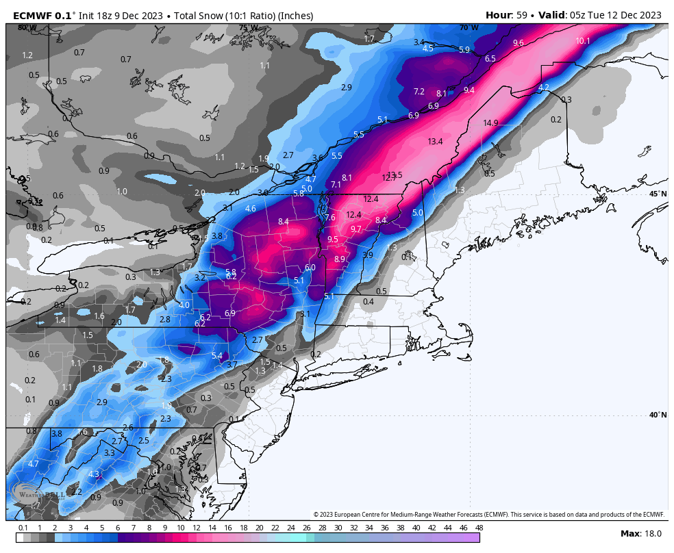
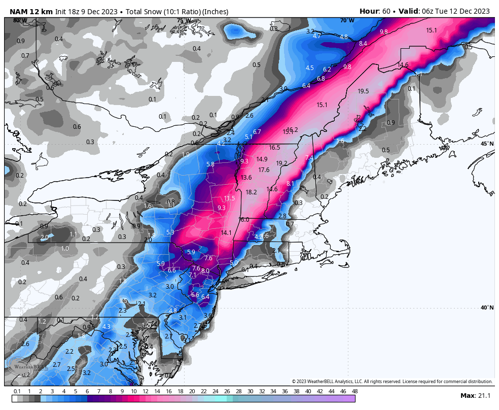
And here's a quick peek at some 10:1 ratio snowfall maps from the GFS, ECMWF, and NAM12K just so that you can see the variability between the most recent runs of these models. This isn't easy to forecast, and the big variable is when that storm starts to really amp up strong. Clearly though aside from strength and some small shifts in track, models are in good agreement.
Sunday Precipitation Timing and Wind
Here's your ski day simulated radar loop for the Sunday ski day to gauge how long it may stay dry. Note that initial precipitation will be spotty and timing will be more variable for that stuff.
I've made some big changes to the wind hold forecast as indicated in the intro because the wind will look different due to the storm starting to wrap up a lot earlier than it looked like yesterday, plus the shift east is changing things. Wind will generally let up as the heavier rain starts. The combination of rain and wind will likely make ski areas more likely to call holds. Southerly wind hold forecasting is always lower in confidence than from the north and the east due to terrain blocking and variability in how close to the ground these types of winds have.

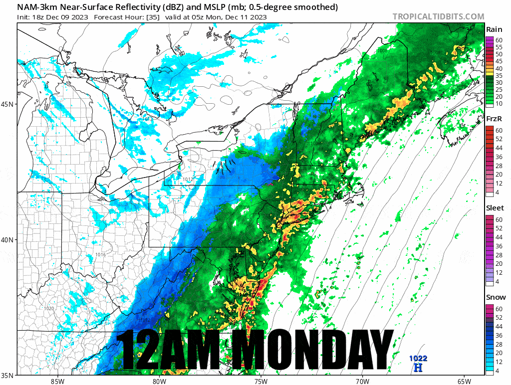
Monday Precipitation Timing and Wind
Snow should start no earlier than 3 hours before Monday starts so this catches virtually the entire event. This is time stamped and play close attention to how heavy the snow is should you be thinking that it would be smart to try to hunt this by driving out early Monday morning. I'm not saying that no one will try, but they need to also get lucky with the wind on Monday. Tuesday is a safer option and I don't want to encourage people to drive through heavy snow. I know people will however, and even do it with nearly bald all season tires because powder fever runs high. That would be insanely dumb though. If you know what you are doing, fine, but this is absolutely white-knuckle shit folks and I hope I'm making my point clearly. Same goes for leaving Monday evening. Oh, and that rain will also suck to drive through along with the wind. Hunt Tuesday if you aren't already holed up in the right spot!
And now for the wind holds. The most persistent winds will be south of the Killington latitude. Wind holds in Northern Vermont likely start around 1PM. We will probably see wind reach the Whites and Longfellows in the last 2 hours of the ski day so that doesn't count since wind holds are not considered notable if they last less than 2 hours. One more note, I didn't have the time to check to see who all was operating on Monday. One of the downsides of expanding maps is tracking operations which is time consuming and I need to get this update out, but I've skipped forecasting some who I knew would be closed. I expect some closures on Monday also for the combination of wind and rain.
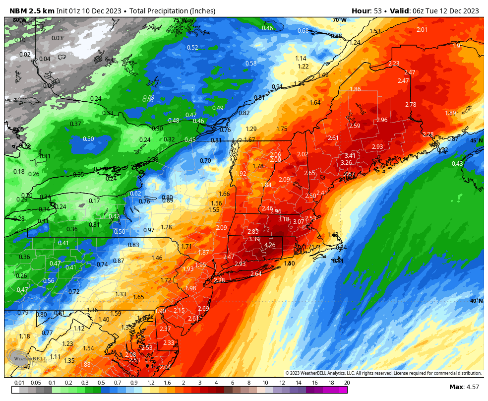
Lastly, the Damn Rain!
Thankfully the shifts in the storm will lighten the rain with both added snow and a shift east. It's going to be pretty bad in Southern New England, Southern Vermont, NH, and ME. You can subtract the forecasted snow from these totals by about 1" of rain for every 10" of snow expected.
You'll see me again tomorrow with an update on snowfall and wind holds. Make good choices and be safe, but also have fun.
Knowledge Is Powder!
Matt


Comments ()