So, this is our 6th daily post about this storm starting with the Storm Watch issued on Tuesday and then daily updates as I drill into the details and get a better grasp of what is about to happen. Our subscribers should have a firm understanding of this storm now, and I believe we are fully dialed in with this update.
What's changed since yesterday's update is that models know which low pressure center will become dominant as they travel up the boundary and that was the source of all of the notable variability between the models. The ECMWF ended up winning this battle and even just last night there were three different solutions in the models that I primarily consult. Unfortunately the solution that won was the least amped and fastest moving of all of the solutions and that means less snow due to a faster moving system. The snow distribution however has not changed from my forecast yesterday. So let's take a look at the full view in a loop that goes from 4PM Sunday through the end of Monday.
Regarding driving, driving into this storm on Monday morning won't be fun. The change from rain to heavy snow will produce likely a lot of slush on the roads and that can be some of the worst stuff to drive in as it tends to keep you off the pavement and push you around. Nearer the mountains this will become icy and slick. The drive home after 4PM though does look better due to the faster progression of this storm, but you may want to let the plows catch up in VT and it will still be bad near the mountains.
I will not be addressing the rain again, but as you probably already know, it is going to cause a lot of damage in most of New England with the exception of Vermont, probably from Killington and North, but at least Southern Vermont should get a decent resurfacing from Mother Nature.
I have updated our Snowfall Forecast, and our Wind Hold forecast, and I feel pretty good about where things stand right now. This update will be pretty brief because it is primarily deterministic now, but I'll try to point out the details that matter concerning both snow and wind on Monday. So here we go!
Precipitation and Timing
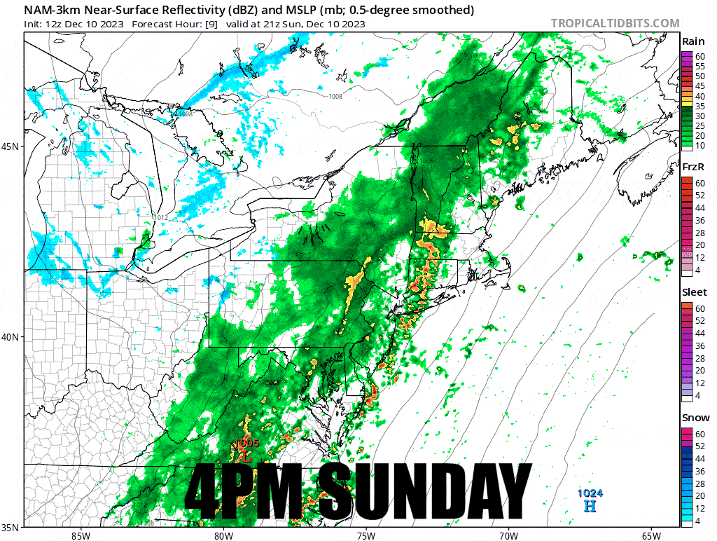
I'll start this time with a timestamped simulated radar map from the NAM3K showing 4PM today through the end of Monday.
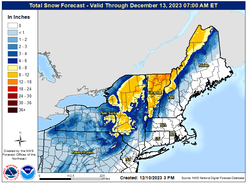
Snowfall
We've unfortunately lost about 5 hours of snow from this system due to the faster progression that won out and a weaker low pressure center, but the focus of the snow hasn't changed much since yesterday evening's update.
While I'm still forecasting over a foot Northern Vermont, I don't expect anyone to break 18" and some may end up nearer the bottom of the range instead this time. Remember as always that the edge can vary a great deal due to changeover lines varying slightly. The Whites and the Longfellows for instance have some extreme variability that is possible, and even Burke is a little too close to the edge for comfort. Some of this snow does fall after close also and much of it during the ski day in New York and New England. Northern Vermont and the Eastern Townships is the place to be for this storm, but keep your eyes on the Catskills for the possibility of over-performing.
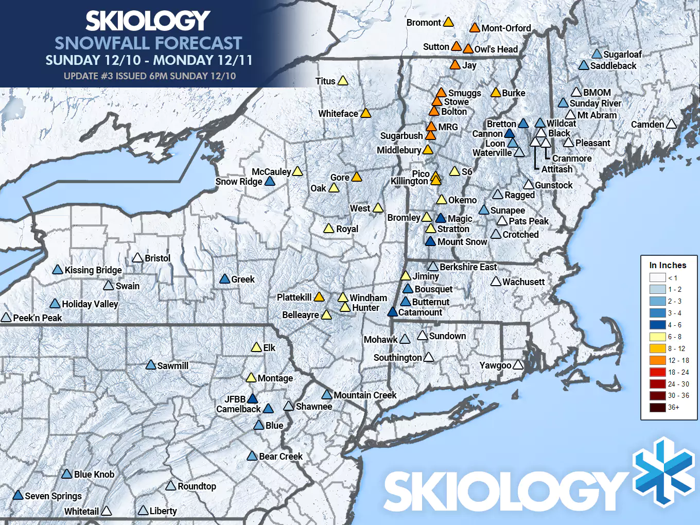
NWS offices finally bumped a notable amount today all over VT, NY, and PA, coming more inline with Snowology's forecast which bumped yesterday evening and then trimmed a little today due to the faster storm. This is a notable change from the NWS in the last 24 hours.
Note: The NWS forecast includes 1"-3" snow in WNY and the western ADK's from Wednesday which is not part of the Snowology forecast range and is a common issue with people interpreting the NWS regional maps due to the 3 day timeframe they cover.
Wind Holds
I did try to gray out those who I know to be closed on Monday, though I haven't had time to check and see who were scheduled to open and decided to close for the storm on Monday. Please always verify with the ski area that they are open and operating on every single day you wish to hit them up.
First will be our wind hold frecast which lists the probabilities of losing or complicating access to +25% of non-beginner terrain to wind holds on lifts that last for 2 or more hours. Then I'll give you all a loop of the hourly guses as modeled by the HRRR during the ski day.
Note Regarding Jay Peak: Jay might only be running Jet on Monday, but verify on their site what their plans are for Monday. The Tram is highly unlikely to be able to run in moderate winds on Monday, and it's not clear than any other upper lifts besides Jet are scheduled to run. Flyer would also have about a 50% risk of a wind hold if it was scheduled. Bonaventure and Jet would have less than 10% risk. They are marked as high risk due to the unlikelihood of the Tram running on Monday due to wind.
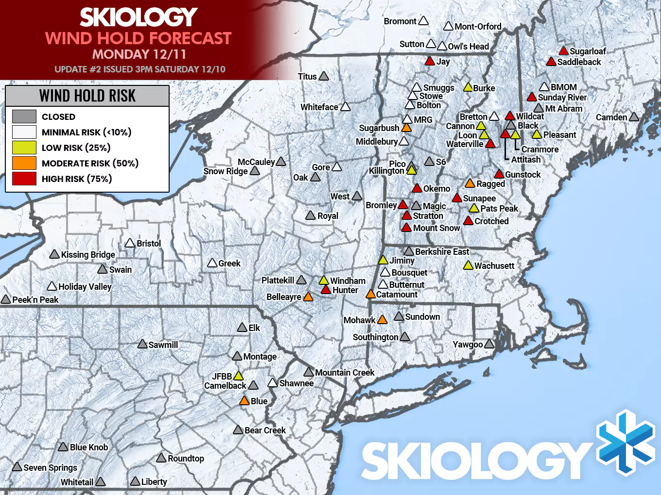
The Poconos and the Catskills potentially have wind issues all day long. The Berkshires and Southern Vermont start getting into the wind probably around 10AM and the risk will grow until about noon and then start to subside there. Wind issues in E-MA and NH starts around 11AM, and then by noon it spreads to Maine and will persist through the rest of the ski day.
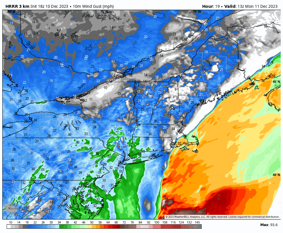
Here's an hourly map of the gusts, but note, our Wind Hold forecasts are not simply wind speeds, not by a longshot.
Now go out and hit it!
-- Matt


Comments ()