Models are still working things out so there is a lot of potential variability in this storm despite impacts being 5-8 days out. Deterministic weather apps are going to be flopping all around in general, though that is often the case with active weather until we get much closer to the event. Rain is likely though during this period, at least to start. We will be in southerly flow between an approaching cut-off low in the Midwest and the backside of a high that moves out to sea starting Sunday and you really just can't win in that situation unless the timing changes.
Storm Watches are provided in full for free to everyone, however Storm Updates will follow and their content will primarily only be available to our Premium Subscribers. My storm coverage becomes more specific and deterministic as confidence increases closer to impacts. A 12-month subscription only costs just $29.99 and unlocks all of our content and also provides our Premium Subscribers with our Snowology Club discounts of 50% for lift tickets with participating ski areas and up to 20% in savings from our retail partners. We are adding new discount partners on regularly. If you would like to sign up for a 10 day free trial here's a link to do so:
Challenging Conditions During the Peak Holiday Period
This is poorly timed for one of the three extended holiday weekends for the ski industry. The peak period starts on Wednesday the 27th and lasts through Sunday the 31st due to how the holiday week falls. While the main system probably will clear the Northeast by the end of Thursday, cold air is likely to follow which would ice things up for the weekend due to preceding warm weather and possible rain. Some back end snow is certainly possible however and those effects may last through Friday or later along with the possibility of some wind.
Icy Christmases are not uncommon in the Northeast as we transition from more marginal and variable temps to more consistent cold around this time of year, but with below average levels of terrain and the propensity of some ski areas to run as many lifts as possible in combination with less experienced skiers and riders, the trails themselves will probably be extra challenging when things refreeze. Holidays of course are a good time to dial things back regardless of the conditions because of traffic levels and who is on the slopes. There will be a lot of kids doing pizza and french fries all over, and people of all types will end up on trails beyond their ability. This will be especially true at larger resorts, but to a degree you will find this everywhere. Holidays are just simply bring much wider interest in skiing and riding and this is of course an important time for the ski industry and those who rely on it.
General Overview
Models are pretty bad at tracking two major elements involved here; 1) cut-off upper level lows, and 2) the genesis of surface lows along a boundary. The general weakness and broad scale of the energy also means small changes can create notably different effects. This system could in fact miss or have very minor impacts to most of the Northeast, but it is just as likely to drop over 2" of rain on large swaths of several states. Probabilities favor more of a moderate rain event with variable impacts and some sort of snow on the back end.
Right now it seems probable that rain is likely to start impacting western parts of the Northeast on Tuesday and overspread the rest of the Northeast on Wednesday. What happens after this is even more variable though except that things will refreeze behind this system and probably stay mostly frozen in the Northeast through the end of the weekend.
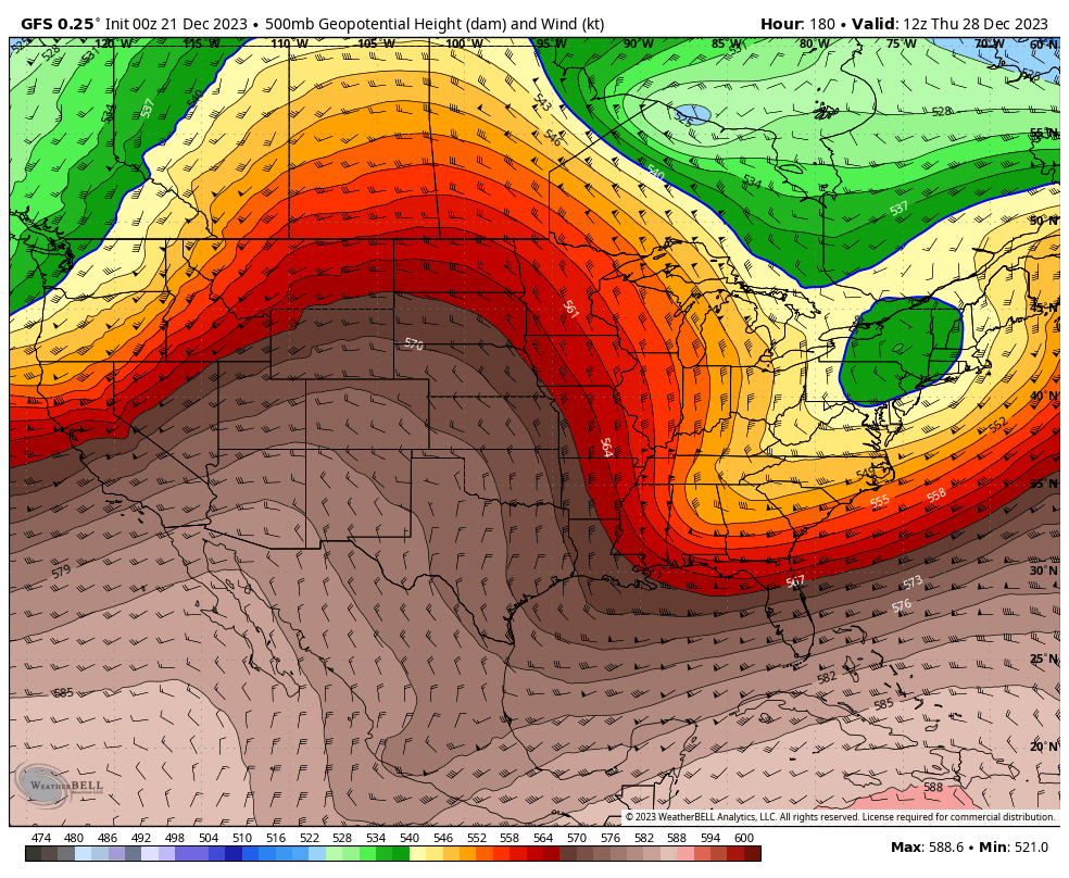
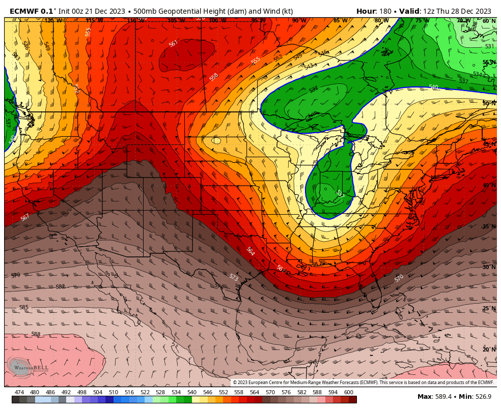
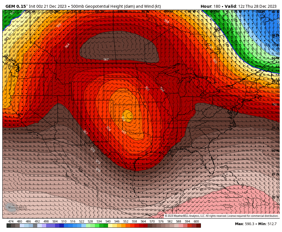
I'm going to start with steering flows at the 500 mb level since this exposes things like troughs, ridges, cut-off lows, and steering flows for storms. The 500 mb level is roughly 20,000' up in the atmosphere. All three models have significant and impactful differences that by the following Thursday morning results in completely different storms and impacts, in fact the GEM sees the storm spin into oblivion without advancing east because it is never picked up by the steering flows and then gets blocked from advancing into the Northeast. This is what each of the main medium-range models sees for Thursday morning as far as 500 mb pressures go (technically these are geopotential heights but that's too jargonistic for most skiers and riders).
Modeling Walkthrough
I'm going to go through all three major medium-range models with 6-hour precipitation intensity loops from their 0z runs showing this Saturday through the following Friday with some brief observations and opinions added for each. All models are likely to be significantly off overall, especially starting around Wednesday or Thursday of next week, so it really is too early to look at things like precipitation totals. We're not even positive that there will be any significant precipitation in the Northeast next week much less where, when, and how much.
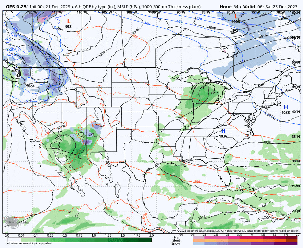
GFS (American Model): While the GFS tends to be much more stable and realistic at this range, it may well be wrong enough to for the storm to look very different than shown here. I believe it may be advancing the upper level low too quickly to the east. You can see the progression of this storm east and how multiple smaller surface lows are generated in front of the upper level low (which may be difficult to spot without a trained eye). If it was slower then more of the precipitation could fall as snow after some initial rain.
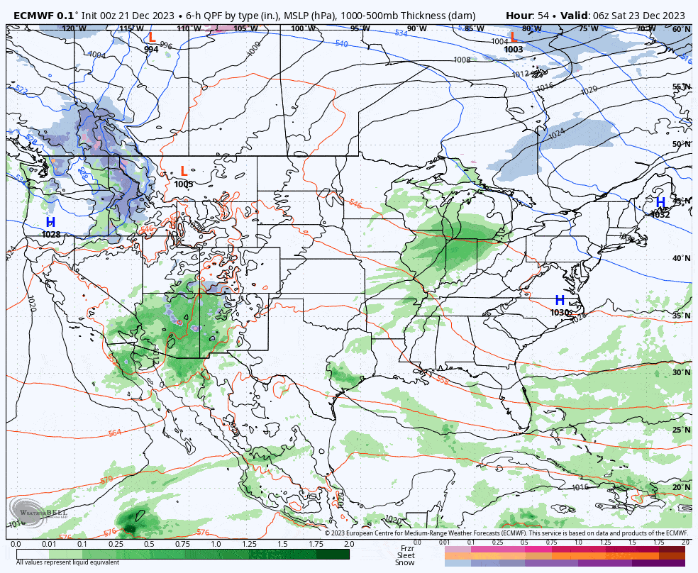
ECMWF (European Model): The ECMWF sees a slower eastward advance which I believe is more probable, but the model also has an over-amping bias for East Coast storms that often affects its modeling at 3+ days out, so that warm nor'easter that appears on the coast Thursday and Friday is likely not that big of a storm if this generally confirms. If the slower eastward track happens, the upper level low is more likely to stall near the Northeast and tap some cold air for an extended back end and maybe something strong-ish forming on the coast. A coastal storm forming later might be able to tap more cold air and provide some parts with bonus snow.
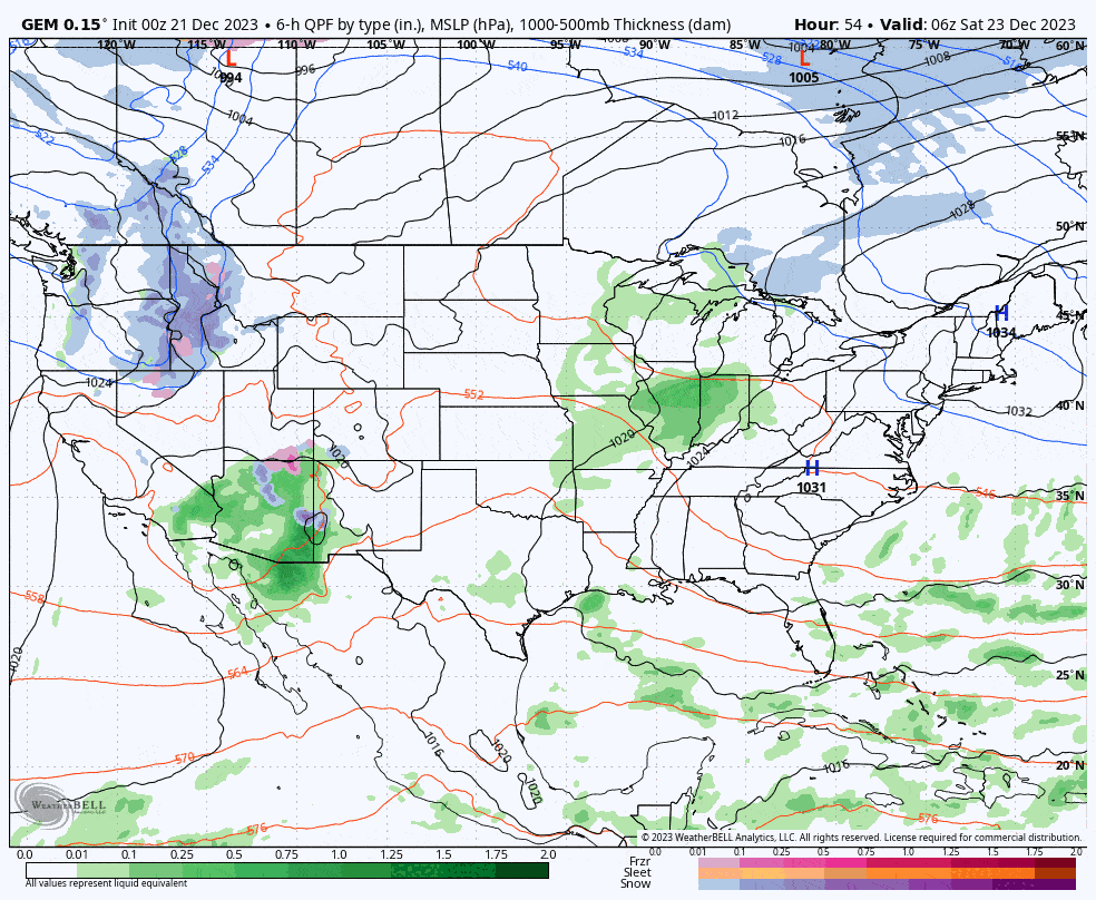
GEM (Canadian Model): And then there's the GEM model which shows the upper level low getting stranded by atmospheric flows in the Great Plains, allowing for the backside of a trough to start to sag into the Northeast and deflect this storm off to the southeast. This could happen, and if you removed the overamping bias from the ECMWF it could look more like the GEM than the GFS earlier in the storm. Having the low completely stranded though in the center of the country seems unlikely at this time.
Knowledge Is Powder!
-- Matt


Comments ()