In the last 24 hours we've seen some positive trends towards less rain. The second storm potential is still in the running, and if it fails we might see a strong back-end snow event, or the third strongly competing scenario would be semi-deflection. If you don't know what that means I'll tell you later.
Many underestimate my ability to will storms to a better result. Of course I'm kidding, but that doesn't keep most of us from trying. All I want for Christmas are edgeable surfaces for the holiday crowds next weekend, and some fluffy snow falling to set the ambiance might just make it feel like winter again.
I'll break this all down in not so technical terms if you love skiing and riding, the weather, and all of those other associated things as much as I do. As a special treat I'm not going to paywall this update at all and wander away from my more typical approach to a bit of forecasting exploration using this storm as an example.
If you appreciate Snowology's coverage, whether it is exploratory like this update, or the deterministic forecasting of storms, and haven't yet subscribed, here's a 20% off discount good until the end of Christmas!
Cut-Off Lows Are Unpredictable
Sometimes weather models are great at seeing what will happen even up to a week out, and this is especially true in non-active weather. Temperatures on a clear and calm day are not difficult to predict within a margin of error that it matters to us most of the time (snowmakers will take issue with this though). This is one of the reasons why the only actual types of weather I forecast that others also forecast are precipitation types and snowfall. That's active weather, and in the Northeast those are pretty hard to get right and how I can provide value.
One of the things I've learned in model watching and forecasting over almost a decade now is that "cut-off lows" are not modeled well, and I'm going to explain why in a simplistic manner and that will help you understand why we don't yet know how this next storm will evolve and what the impacts will be on the mountains.
A cut-off low in the most basic terms is a spinning mass of generally rising air that has separated from the main steering currents found in the upper-levels of the troposphere (where the weather happens) and best seen at the 500 mb level which is about 20,000 feet up. Without notable influences from steering currents these lows tend to wobble around due to the effects of weak winds, moisture, and even terrain. It's much like trying to predict where a spinning top might travel.
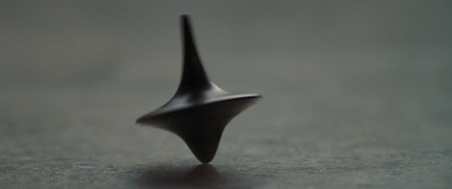
Weather models are physics models, and they are imperfect in large part based on the the level of detail they can see and the level of detail they can be fed with for current conditions. You could create a computer model to predict where that spinning top would travel, but it would be impacted by the same things and it would be very difficult to do. So cut-off lows in the upper levels are just simply hard to model due to their nature and that means that forecasts even 3 days out are subject to lower than normal confidence.
I'm going to demonstrate the difficulty in modeling cut-off lows with this storm by using three different models/runs of 500 mb heights with some other overlays. This is what the storm looks like from Wednesday through Saturday. By Thursday morning, just 4 days from now, these three models/runs end up with very different results.
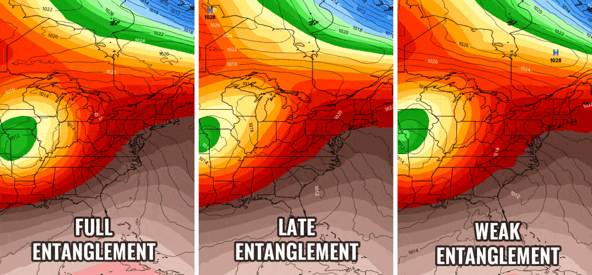
One other thing about cut-off lows is that troughs love merging with them. It looks like a drip of water in reverse. Once they get close enough it tends to happen quickly and that completely changes the flow around the system. I labeled three different levels of what I call "entanglement" which is the degree of interaction between an upper level low and a trough.
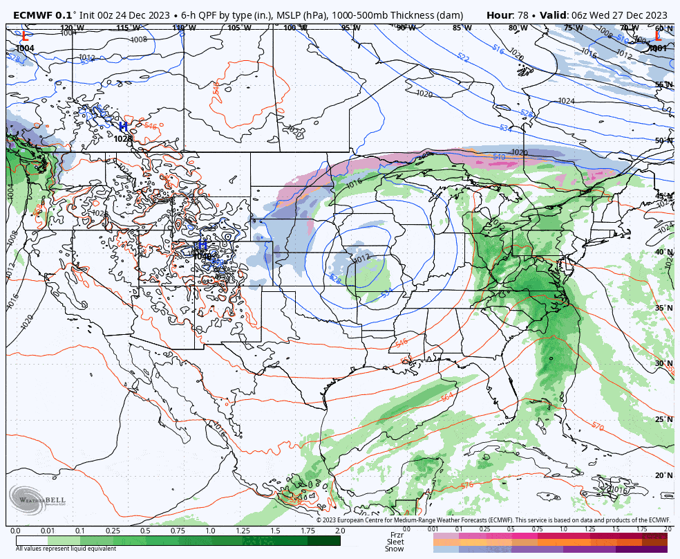
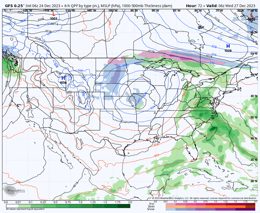
The Full Entanglement example results in a an extremely weak second surface storm forming and a bigger back-end. The Late Entanglement example produces a weak second surface storm, but it would disrupt the flow for a back end and lake effect would be less likely. The Weak Entanglement example would result in the the storm being suppressed and would minimize the rain from the first surface storm, and make both the second storm and the back-end not happen within our region. The Full Entanglement example comes from the 0z ECMWF and here's what the precipitation and height modeling looks like.
Having access to models doesn't make you any more of a forecaster than having access to a race car makes you a race car driver. You have to know how to use it in different conditions and the more you observe and practice, the better you will get, but also the better you will know your true limitations. If you were forecasting this storm then you wouldn't yet want to pay much attention to what happens on the surface even though that's all we really care about. Early attention should be on the 500 mb heights because what happens on the surface depends primarily on how the cut-off low entangles with the trough. If you watch these enough then you will grow to understand that a storm in the East involving a cut-off low is highly likely to be poorly modeled until about 3 days out at best.
Where the Snowology Forecast Stands
Models, both the deterministic single-run versions and the ensemble multiple-variation versions, are pretty evenly split on roughly one of those three scenarios described above. The ECMWF ensembles show all three scenarios in the results and as you can likely see, there's no strong favorite. And yes, the lack of detail from looking at 50 postage stamp-sized graphics is purposeful and useful in this instance. Confidence of a specific result is not strong.
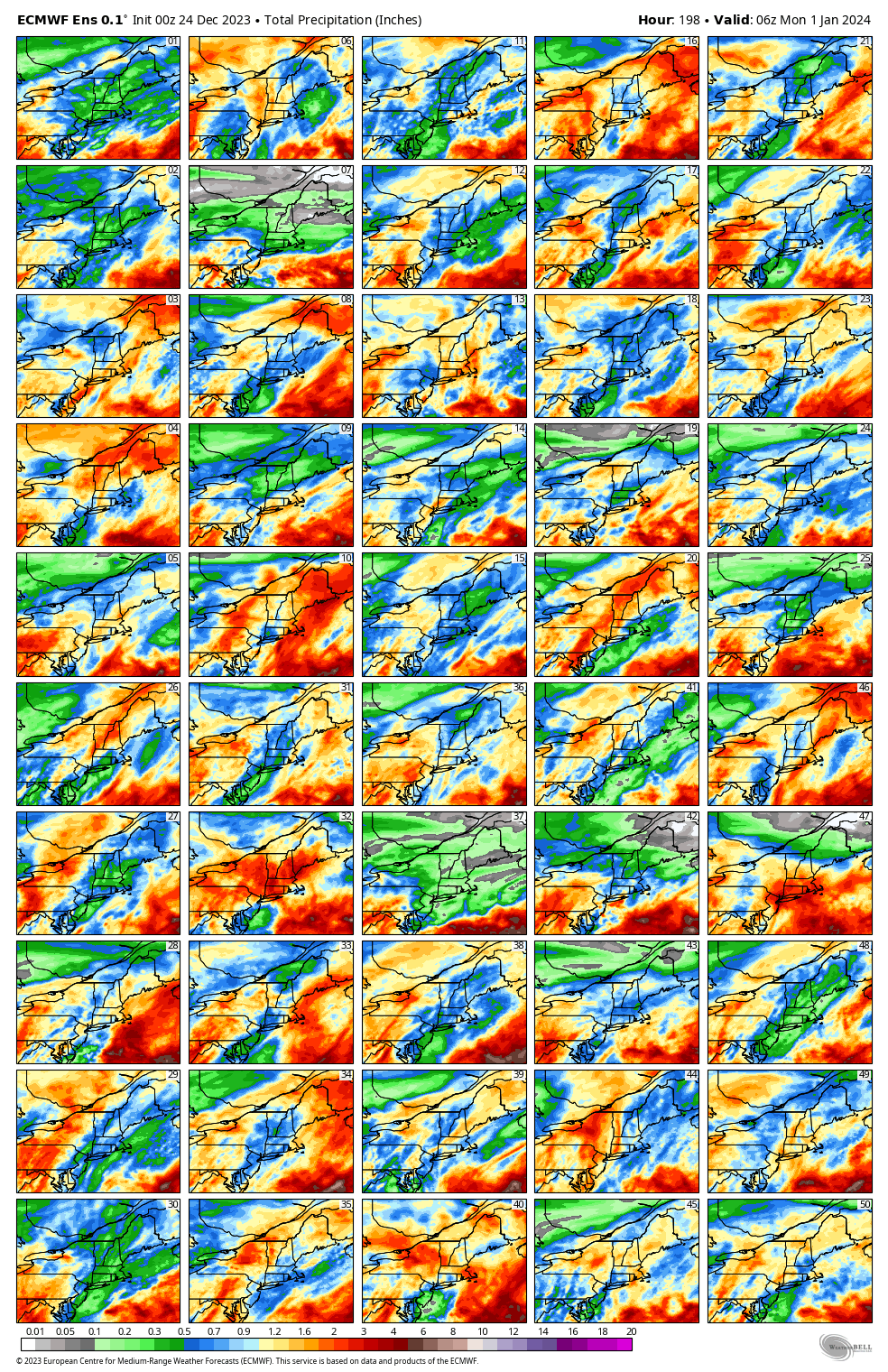
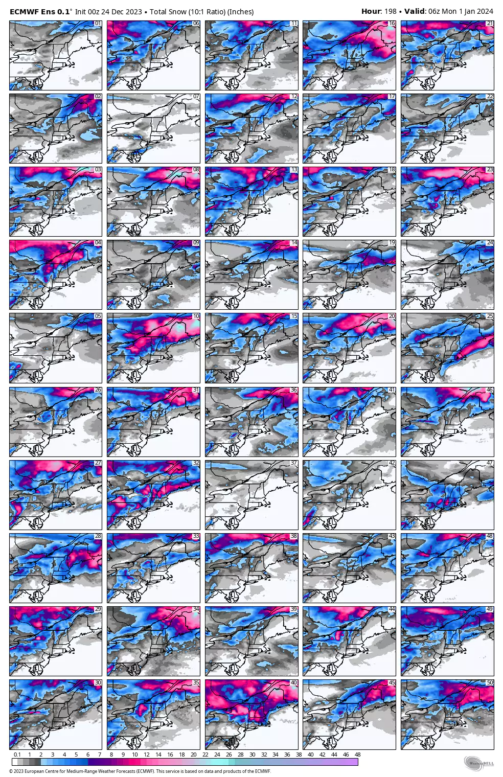
The only thing I can use to improve upon the roughly even probabilities is to reference trends. The primary trend generally seen in the deterministic models is the cut-off low tracking east more slowly and getting more separated from the first storm that forms and tracks up the coast, and that storm is also generally modeled weaker and further off the coast. This is a trend towards the Weak Entanglement scenario which suppresses the advance of the rain and eliminates the second storm chances as well as the back-end. This is what the 6z GFS run has now flipped to favoring.
The semi-suppression scenario would fail to pull cold air in behind this storm and that would mean afternoon softening through the weekend at many ski areas which would really help in present conditions, but also much more muted snowmaking as the cold slowly advances into the Northeast over the following week.
What is my confidence in the Weak Entanglement/semi-suppression scenario? About the same as my confidence in sticking the landing going over a small cliff drop on a powder day...sometimes you get lucky and if I land it I'll blurt out a hoot. I would prefer the more snow scenarios though, but less rain is a good consolation prize. I rate the semi-suppression scenario as 40% likely due to trends, and a 30% chance of a decent second storm tracking through the Northeast, and a 30% chance of full entanglement that brings with it a back-end snow event.
Don't forget to leave some RedBull and bacon out for the snowmakers this Christmas otherwise you might get core shot from a lump of coal!
-- Matt


Comments ()