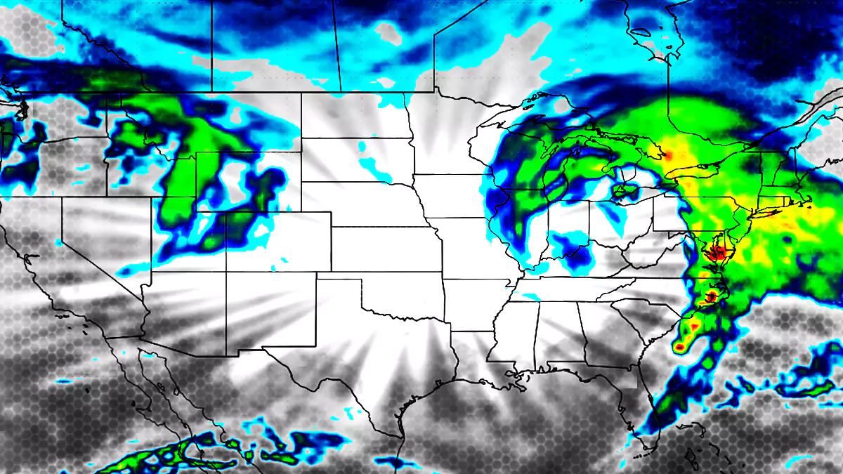
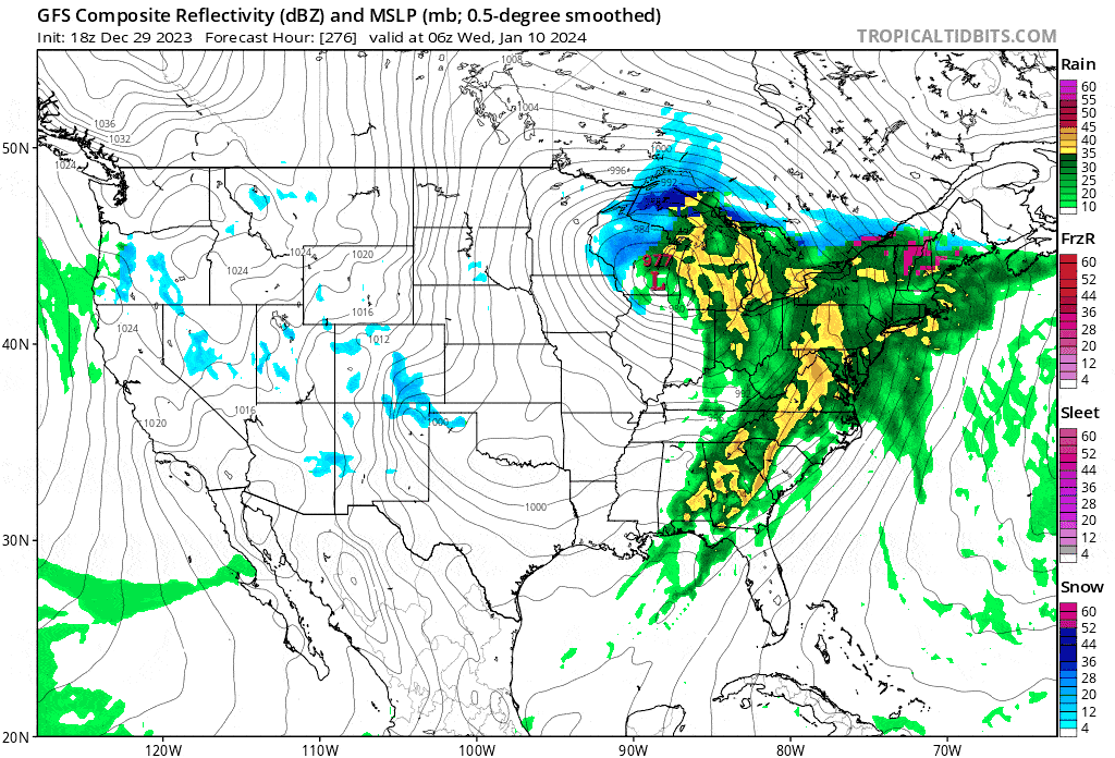
I'm calling this a Storm Watch, but we're getting a storm and it will be exactly 3 days behind the one this weekend. Models started picking up this storm 6 days ago and it has remained a very large and strong storm in the models since then. It has looked really scary (widespread heavy rain) in many model runs but it's not uncommon to see apocalyptic looking modeled storms in the East at 7+ days out which is one of the reasons why many call that the "Fantasy Range". Here are the last 22 runs (5 1/2 days) of the GFS showing this storm early Wednesday morning to show the evolution of the model and more consistency in the last couple of days.
This storm is likely going to be a cutter with a strong inland low passing over the Great Lakes, but it has been drifting east slightly in the models and taking on a more mature T-bone like shape which has given rise to the possibility of triple point low where a secondary low forms off the coast and helps keep the cold air locked into parts of the region. I created the following graphic for a storm in November showing how the secondary coastal low feeds cold air in between the two circulations and helps keep the push of warm air at bay. You need a coastal low that is strong enough to resist the warm air push from the stronger primary inland low. You also need a more mature storm for this to occur.
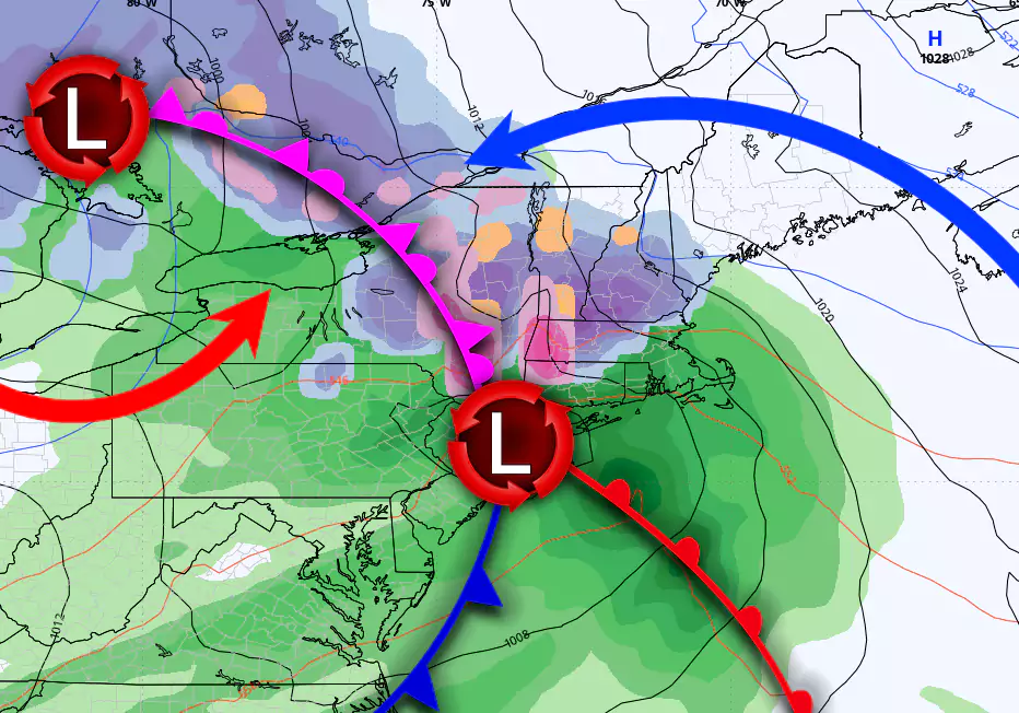
If this storm keeps drifting east it could become more of late transfering coastal storm with where the coastal low becomes stronger and most of the surface energy is transferred to the coast, and that's an even colder and snowier solution and models are starting to hint at that. The storm is unlikely to to track far enough east to become purely a coastal storm.
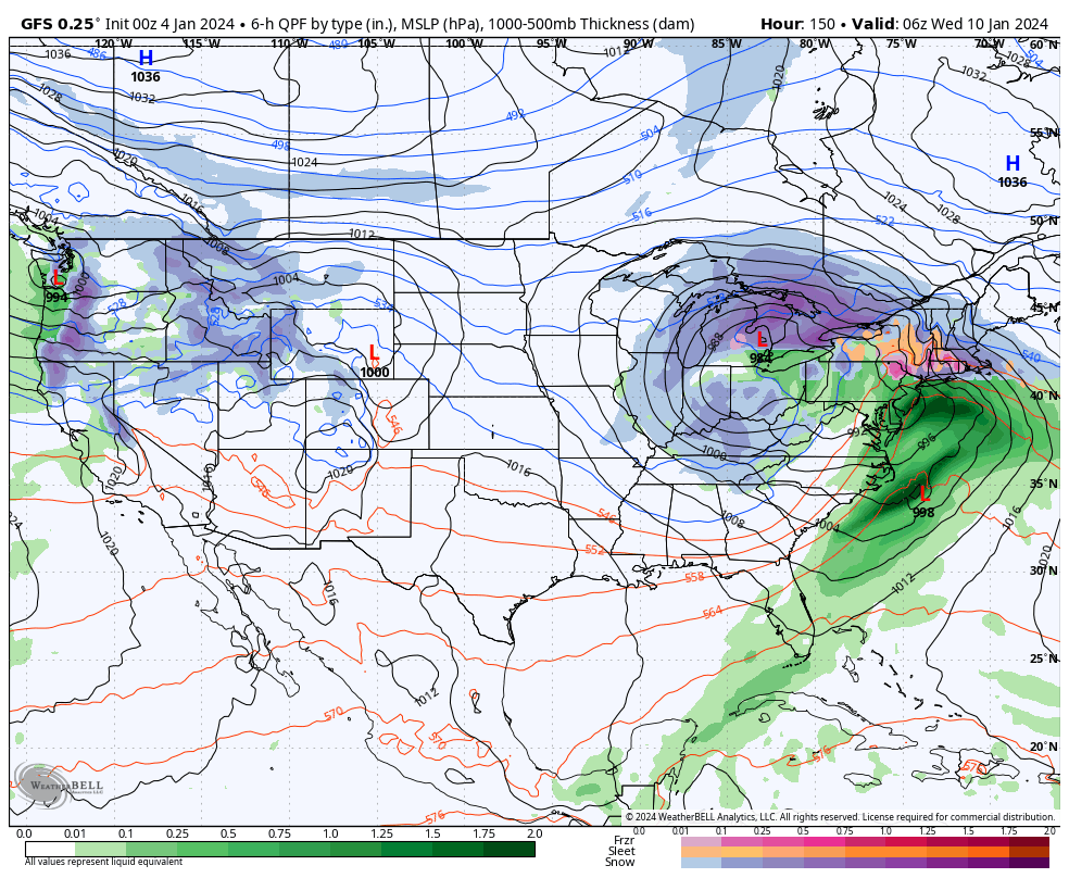
This is a BIG storm in the models at present. This could be great for parts of the region with some receiving over a foot of snow while being a washout at some southern and more coastal ski areas, it could be a widespread washout with up to +3" of rain, and it could also weaken tremendously and take on very different characteristics should something still unforseen happen.
While Storm Watches are fully free, Storm Updates contain content that is mostly available to Premium Subscribers. Snowology offers a 10 day free trial for those who wish to test drive our coverage, and we also offer discounts for ski areas and gear.
Where The Models Stand?
Let's take a look at the three major medium-range models show for Wednesday morning. Those models are the GFS (American), ECMWF (European), and GEM (Canadian),
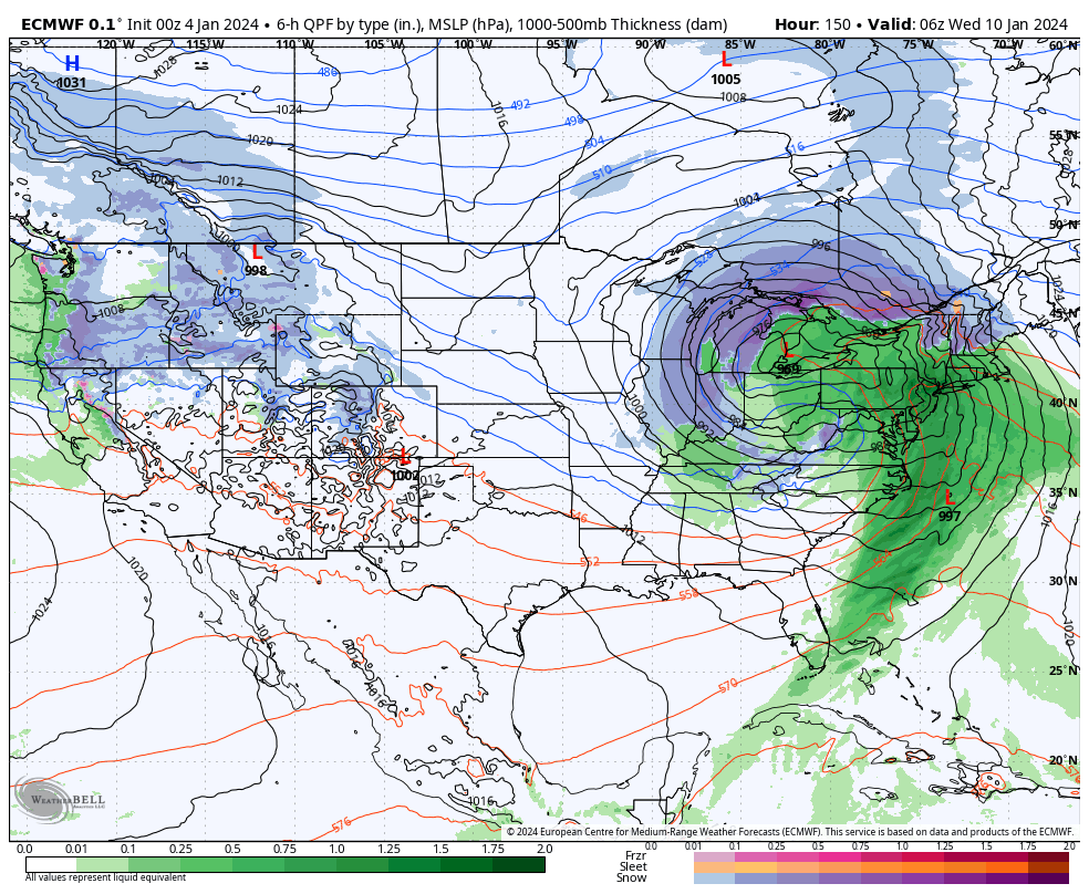
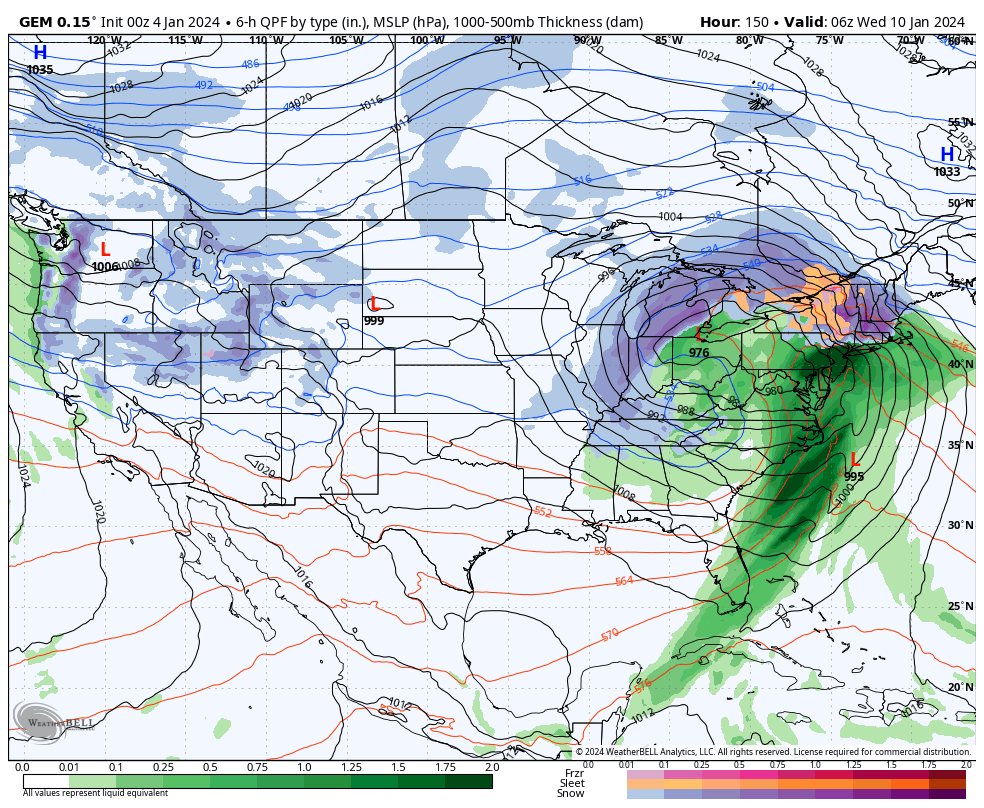
This is pretty remarkable agreement from the bird's eye view for 6 days out except for one BIG thing, the strength of the cutter's low, and the range between the three is 20 mb, which is huge.
If that inland low is too strong, it won't allow the coastal secondary low to lock in the cold. The ECMWF sees the inland low reach 964 mb, which is crazy strong (lower pressures mean stronger storms). That's technically possible, but highly unlikely. The GFS on the other hand sees that inland low only reach a minimum of 984 mb, which is very strong, but not unreasonably so, and as a result that model not only sees the cold locked in to keep broad areas all snow, the coastal low also takes over and sees and energy transfers from the inland low. That's probably the best result we can hope for with this track, and while some get mostly rain, most do not. The GEM model is currently about half-way between the other two and would mean a change to some rain expect for the Whites and Longfellows (N-NH and N-ME) which is a typical sort of triple point low result.
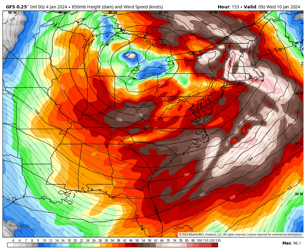
Wind Presently Looks Fierce
If this storm comes through anything like shown above, the wind on both the front-end and the back-end could cause widespread issues. This is what the weaker of the three, the GFS, shows for winds at 5,000' on the front-end (over 100 mph). If this storm maintains similar characteristics it is possible that some ski areas could go 2 full days without upper mountain lift access, and this will also redistribute the snow in a very uneven fashion (if it falls as snow). Those sorts of storms can be tough to hunt for a lot of people, but there will always be exceptions and unlike prior years when coverage was available to everyone, I will now tell Premium Subscribers where to go to avoid the wind!
This is a big one folks, so cross your fingers it turns in our favor!
Knowledge Is Powder!
-- Matt


Comments ()