First off to all our our weekenders out there, I hope you got a great pow fix today because every single ski area in the Northeast received snow yesterday and today, and only a handful received some rain after the snow. The biggest total I've seen so far from this storm was 15" at Wachusett, though many have not yet reported the full storm yet, and a little bit of snow was still left to go after 3PM when I started collecting data from every ski area. Let's just say gathering snow totals takes longer than forecasting them 😄
If you want access to the most comprehensive and accurate snow, precipitation type, wind hold, and travel forecasting in the Northeast, there's a 10 Day Free Trial, and we would love to have you! There are 3 storms coming this week, two likely larger including one likely next weekend. Here's a nice note I received today from one of our thousands of subscribers regarding the wind hold forecast:

These Storm Postmortems are free for everyone, but our Storm Updates are mostly paywalled for just our Premium Subscribers. Below are the reports we have collected early this evening, though some are not yet complete. I'm very happy with how the forecasting confirmed.
Snowfall and Precipitation Type Verification
So let's first start off with our final forecast map that was issued at 9PM on Saturday as snow was starting to reach beyond PA and NJ. I made some last minute bumps to the outside edge, the same areas that I had indicated might overperform in the early update on Saturday as the snow was starting. Forecasting is most difficult at the changeover line and on the outside edges for obvious reasons.
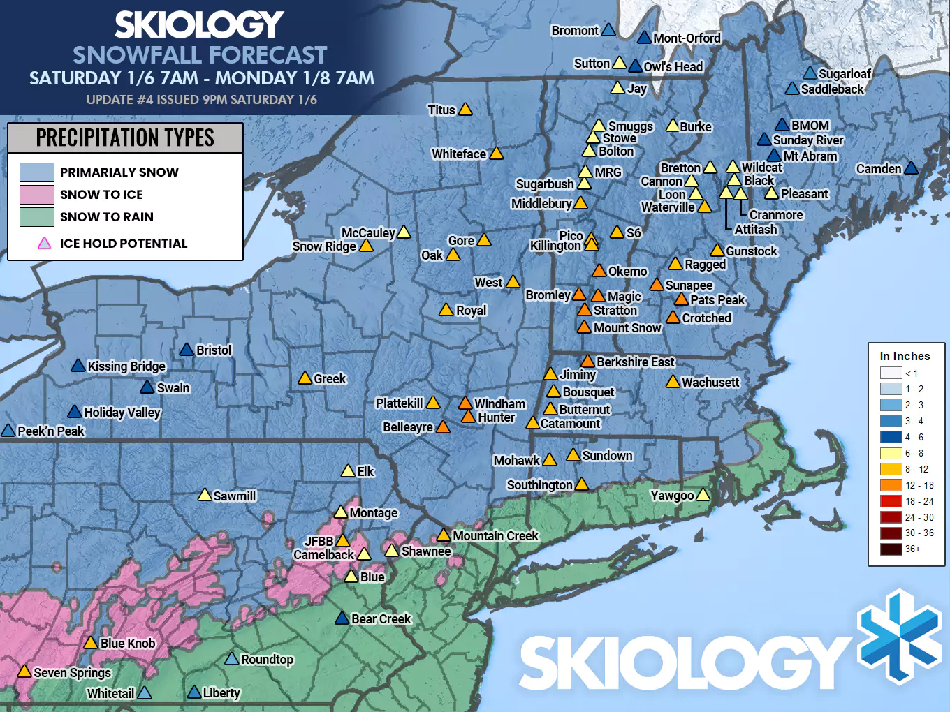
The forecast confirmed very well overall with just one exception. The only real surprise was a dry slot that kept totals down in the Catskills, Berkshires, and Southern Greens. The low last night tracked further east than expected, only to get sucked back when the kicker shortwave combined with it this morning. That caused the heavy bands of snow from the first push to miss this area, in fact a snow hole opened up around midnight across Southern Vermont. Precipitation types confirmed perfectly as far as I can tell.
I forecasted snowfall for over 80 ski areas in the Northeast and here's a list of what they reported as of about 4PM today. Please pay close attention to "Morning" and "Afternoon" identifiers, especially in Eastern New York and New England as the snow was ongoing after open today for these areas. Significant snowfall was seen after the morning in much of this area. Snow reporting by ski areas is also very inconsistent. I forecast for the upper 2/3 of terrain which is generally the standard, but some report from the base, even at mountains with over 2,000' of vertical and hardly any use NWS standards. Most actually under-report snow now and I don't feel like any of these reports were likely too high. After close today 1"-4" is also possible, mainly in Northern New England. Basically the reports from the afternoon will be accurate for each ski area's standards, or 1"-4" below what the final totals are likely to show Monday morning.
|
Connecticuit Eastern Townships New York Maine Massachusetts |
New Hampshire New Jersey Pennsylvania Rhode Island Vermont |
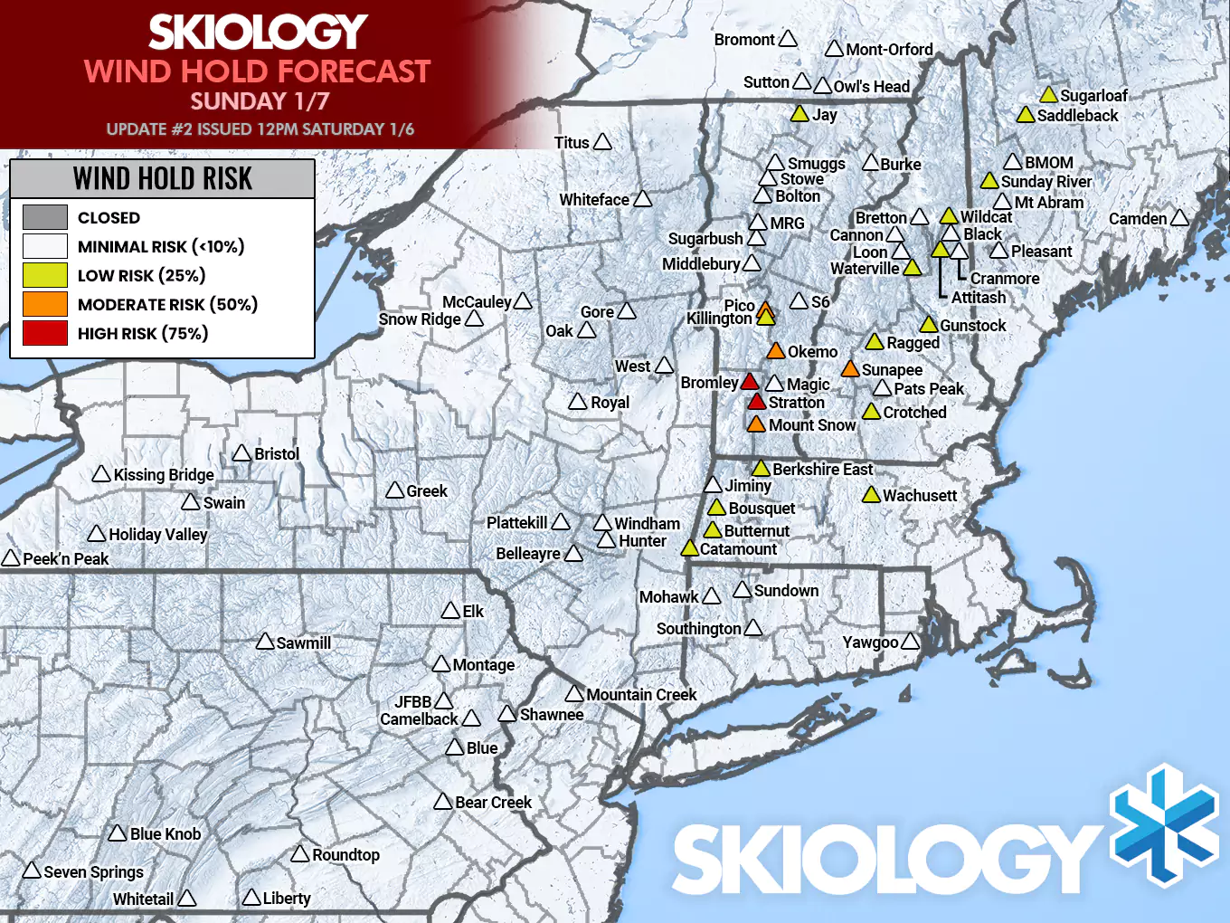
Wind Hold Verification
As far as wind holds go, this confirmed excellently! We saw wind holds at Mount Snow, Stratton, Bromley, Okemo, Pico, and Sunapee. Jay Peak lost their tram, which doesn't qualify on its own, but they might have lost the Flyer later in the day (I was unable to verify for certain). Most lifts came back online by 11AM and our guidance was to expect most issues to pass by noon. Sometimes ski areas will give up on a lift if it doesn't come off hold before noon. Blue and Camelback also had some morning ice holds and I did not forecast those as the ice had passed well before open and this was likely more of an issue with staffing being too low or too late with the complexities of difficult travel.
Knowledge Is Powder!
-- Matt


Comments ()