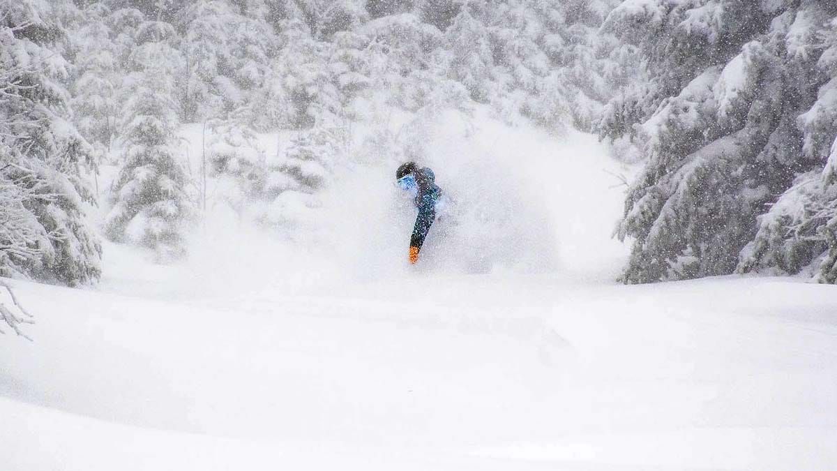
Well, that was pretty frickin' awesome wasn't it? We had some reports as high as 30" of snow, though generally it probably topped out closer to 24" in reality with very strong winds shuffling the snow on the trails and into the trees in some cases. I need to be careful to recognize that it wasn't all snow for the Northeast, there was a good amount of rain in parts of PA, NJ, NY, MA, CT, and RI and more coastal parts of NH and ME. That didn't help those areas who have been struggling with temps all season long. That is however par for the course in March which can be boom or bust.
I took a lot of flak from the uninformed weather app naysayers on social media up until Sunday morning's snow was on the ground, but that just goes to show the importance of having a weather resource focused on skiing and riding and also why details matter! The general weather sources in media aren't big on covering elevation storms, and these are difficult to forecast accurately. Some are expecting me to spike the football after the storm delivered, but I must say, I haven't seen a more consistently modeled storm from 5 days out as this one all season long. Every single model run from the big-3 showed unwavering support for snow at elevation the entire time, the only trick was to get the snowfall amounts correct and help steer people around the wind and into the knee-deep pow. The confusion was from trusting resources that are automated or misunderstanding how forecasting is done and the timeframes. Below are the NWS forecasts for this storm from Thursday morning and Saturday morning, but the first one only covered part of the front-end of the storm and most don't understand how even the NWS forecasting works.
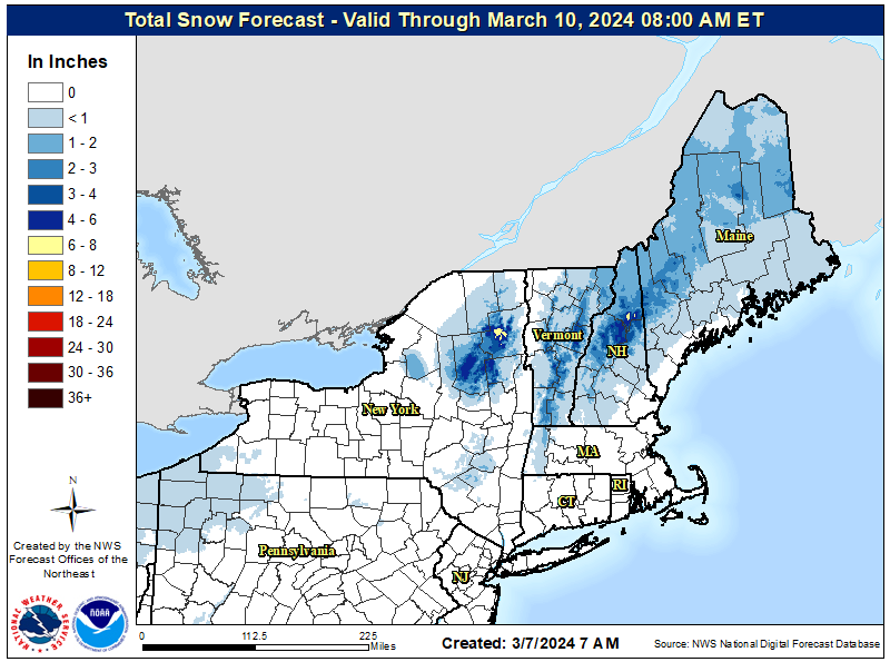
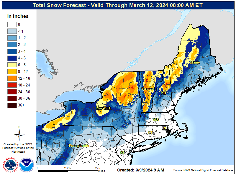
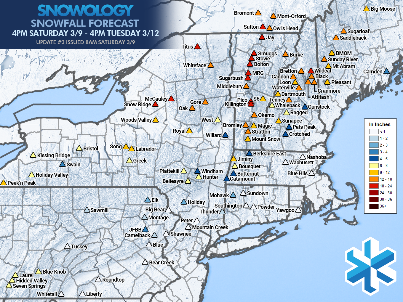
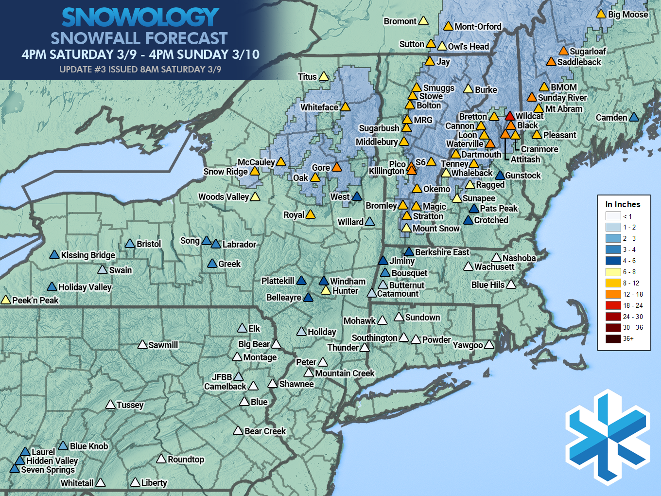
At the same time that I issued our first full storm forecast NWS offices entered their forecasting range and started to forecast snowfall. I was forecasting up to the 18"-24" range through 4PM on Tuesday while at this time while NWS was showing no ski areas at more than 6" and that caused another slew of disbelief, but NWS was only forecasting through 8AM Sunday and the way their forecasting works is it is often light at the end of the 72 hour range. By our final forecast on Saturday morning NWS was then forecasting the full storm and were in generally good agreement with my own, and that is also normal. I did however aim to try to give a full picture of this storm by extending my own range out to 5 1/2 days which is a perk of a ski area-focused forecast built around the needs of skiers and riders and I can vary my forecasting timeframes if I want. Many don't pay attention to the timeframes of forecast maps unfortunately and so that causes significant confusion, in fact I'm sure on Sunday morning many people showed up expecting 18" or more when the actual forecast was for just 8"-12" by the end of the Sunday ski day. Skiing is costly and time consuming and the details matter!
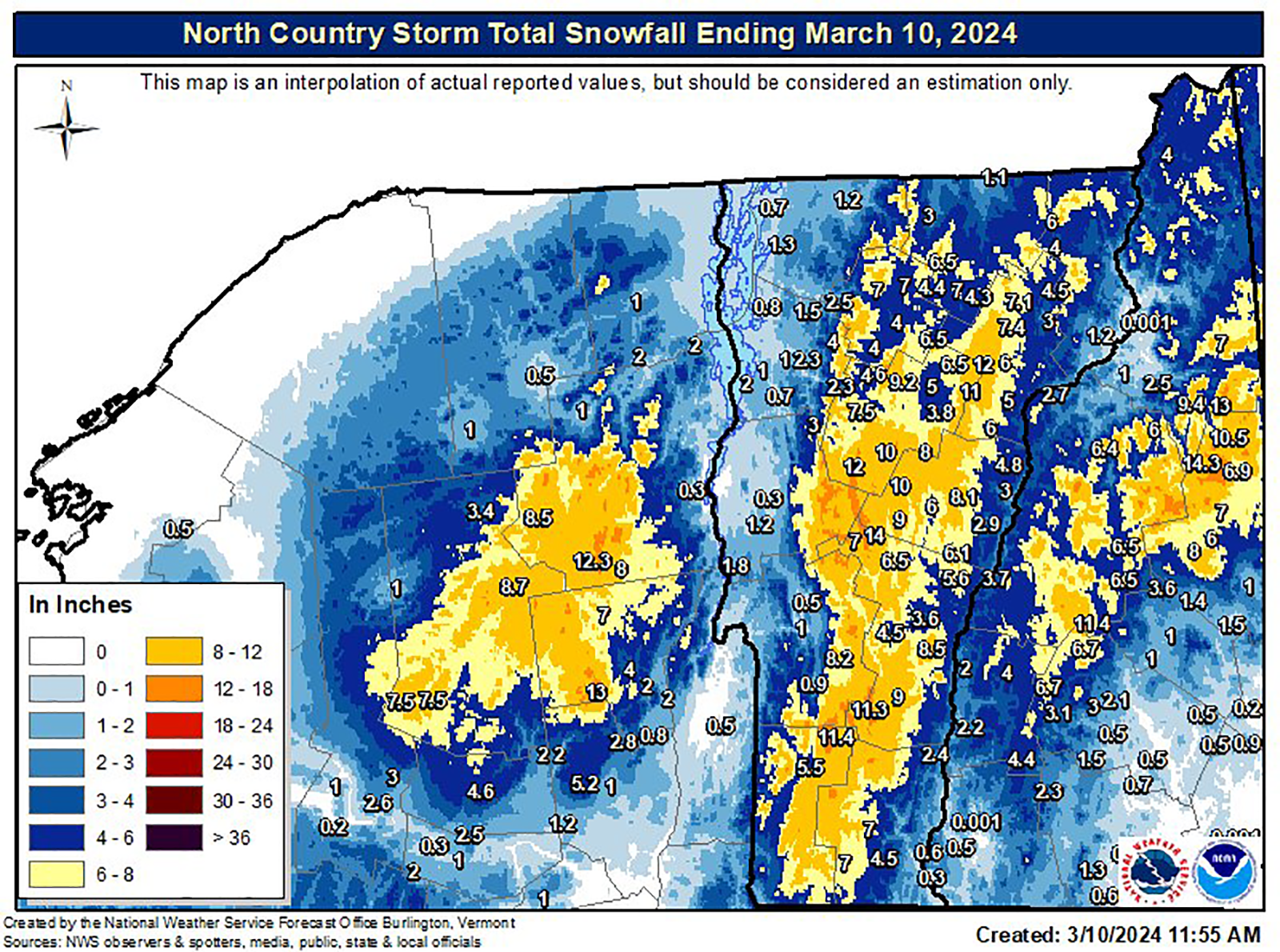
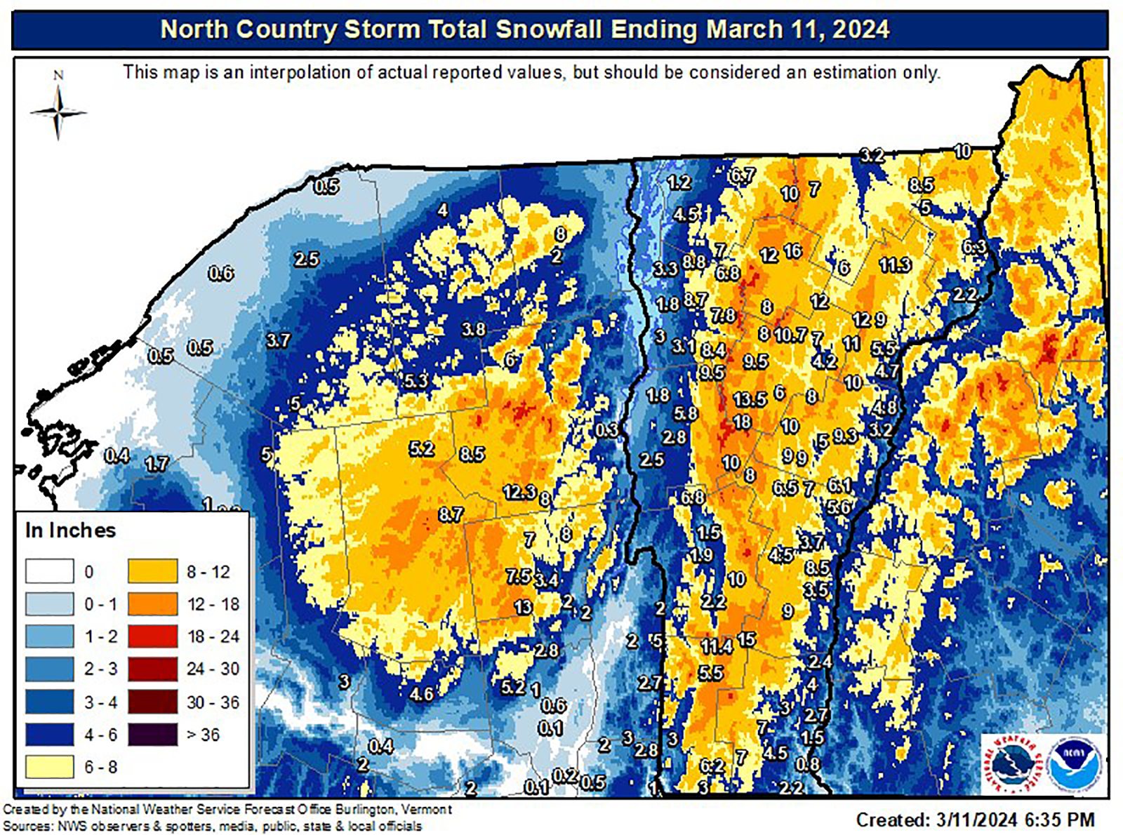
NWS Burlington did some of their detailed analyses following each day of the snow. Unfortunately these didn't cover Maine nor parts of New York, Pennsylvania, and Massachusetts that received some snow on both the front-end and especially the back-end.
The final forecasts for this storm from SNOWOLOGY were actually split into three parts, the first day through 4PM (roughly the timeframe of the first graphic above), then the back-end, and then a full storm total. Here are the final SNOWOLOGY forecasts for the first day and then the full storm totals.

We did send out a Saturday evening alert about a slight warm shift that did confirm and primarily kept the snowfall totals down in NY which is where almost all of our misses were. With an elevation storm some variability should be assumed. In much of VT, NH, and ME though the forecasts confirmed very well even though we saw some light rain coat the snow and settle it. The NWS interpolations in this case should be highly accurate with only some exceptions, though ski areas don't measure to NWS standards and 6" of snow that then gets 1 1/2" of rain might be reported at 1" but NWS would see it as 6" and that's how we forecast at SNOWOLOGY. I however forecast snow falling on top of snowpack on the trails and I only have to tune my forecast in one way, but with a lack of snowpack and a warm ground NWS forecasts can sometimes be low in these elevation storms because they forecast mainly for accumulations of snow falling on warm wet ground and that can wipe out up to 3" of accumulation sometimes.
Snowfall Verification Through 4PM Sunday
I did gather reports from all over at the end of Sunday. Note that standardization of snow reporting in the Northeast doesn't exist and so we have some reports that are only updated in the mornings, some measured snow after settling and rain, some report from the bases while others report from much higher up, and then there is the cherry-picking that is still practiced in some cases where they hunt the whole mountain for the biggest snow catch of drifted snow. I believe no one actually saw more than 24" out of this system, but we had some come in high, and some come in low, and under-reporting in the Northeast ski industry is now the most common since pass sales are a bigger driver of business than snow storms for many of the bigs. In this case wind holds caused more base reporting in NH and ME to start, but some were updated later in the day to reflect nearer the summits as wind gave way to warmer temperatures and calm winds.
So here's our forecast through Sunday at 4PM and then the reports I gathered after close that day.
NEW YORK
Belleayre: 3" (after rain settling)
Gore: 18"
Hunter: 1" (after rain settling)
McCauley: 1" (after rain settling)
Oak Mountain: 11" (morning report)
Royal: 5" (after rain settling)
Whiteface: 3" (after rain settling)
VERMONT
Bolton Valley: 12"
Bromley: 10"
Burke: 13"
Jay Peak: 10"
Killington: 12"
Mad River Glen: 12"
Magic: 12"
Middlebury Snowbowl: 8" (morning report)
Mount Snow: 8"
Okemo: 13"
Pico: 12"
Saskadena Six: 8"
Smugglers' Notch: 14"
Stowe: 9"
Stratton: 12"
Sugarbush: 9" (morning report)
NEW HAMPSHIRE
Attitash: 20" (probably too high)
Black Mountain: 10"
Bretton Woods: 8"
Cannon: 6"
Cranmore: 8"
Crotched: 1"
Dartmouth Skiway: 4"
Gunstock: 2"
Loon: 6"
Ragged: 4"
Sunapee: 6"
Tenney: 12"
Waterville Valley: 8"
Wildcat: 19"
MAINE
Black Mountain of Maine: 6" (morning report)
Pleasant: 5"
Saddleback: 14"
Sugarloaf: 10"
Sunday River: 8"
EASTERN TOWNSHIPS
Bromont: 1" (morning report)
Mont Orford: 8"
Owl's Head: 4" (morning report)
Sutton: 4" (morning report)
I did miss on the outside edges of the ADKs due to that warm shift, and also in a few in New Hampshire for similar reasons. A 1F shift colder in temps would have brought more than a foot more of snow to places like Snow Ridge, McCauley, Titus, and Whiteface, and a bit more to Royal, Crotched, Pats Peak, and Gunstock. I did however at least warn about this Saturday evening as the snow and rain was starting and that's important with elevation storms as the marginal edges are where you will find the most variability.
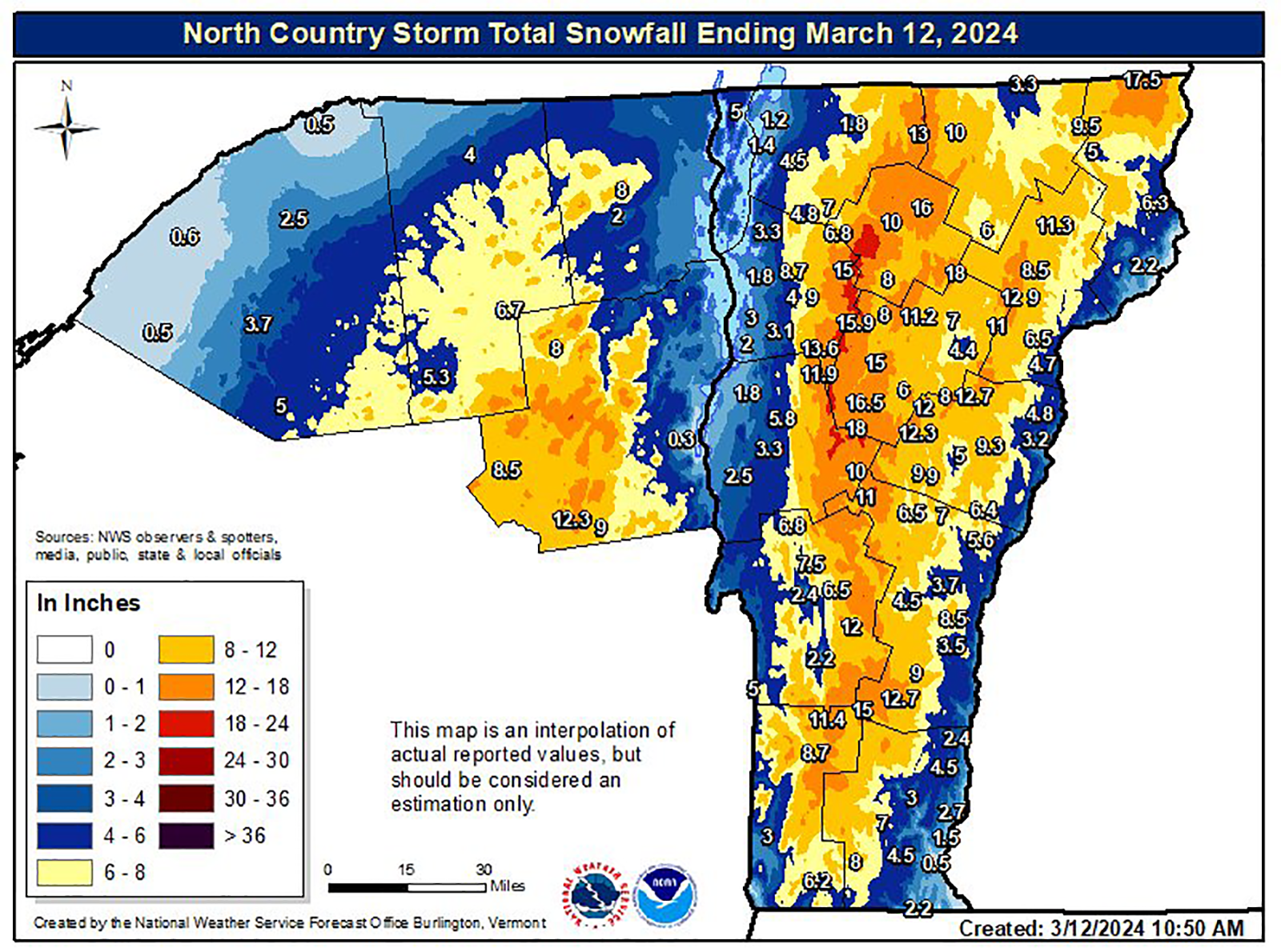
Snowfall Verification Full Storm
I don't often forecast snowfall amounts much beyond 3 days, but with a 2 day long back-end with potential of dropping more than a foot of snow, this was a key aspect of this storm and models were consistent enough to estimate the potential, which is pretty much what I did. The storm did however shift a bit and the snowfall on the back-end in the ADKs underperformed, but it came in as expected in the Greens, Whites, Longfellows as well as off the lakes and upsloping into the Alleghenies. Here was our final full storm forecast from before the storm issued Saturday morning.

Below are the final reports that I gathered on Tuesday showing how much snow was reported for the full storm.
NEW YORK
Belleayre: 3" (after rain settling)
Gore: 24" (probably too high)
Holiday Valley: 9"
Hunter: 1" (after rain settling)
McCauley: 5" (after rain settling then back-end)
Oak Mountain: 11" (Sunday morning report)
Plattekill: 3"
Royal: 5" (after rain settling)
Titus: 4" (after rain settling then back-end)
Whiteface: 11" (after rain settling then back-end)
VERMONT
Bolton Valley: 24"
Bromley: 14"
Burke: 16"
Jay Peak: 28" (probably too high)
Killington: 27" (probably too high)
Mad River Glen: 30" (probably too high)
Magic: 15"
Middlebury Snowbowl: 13"
Mount Snow: 10"
Okemo: 16"
Pico: 27" (probably too high)
Saskadena Six: 8"
Smugglers' Notch: 21"
Stowe: 21"
Stratton: 15"
Sugarbush: 14" (too low)
NEW HAMPSHIRE
Attitash: 20" (probably too high)
Black Mountain: 10"
Bretton Woods: 16"
Cannon: 11"
Cranmore: 8"
Crotched: 1"
Dartmouth Skiway: 4"
Gunstock: 2"
Loon: 9"
Ragged: 5"
Sunapee: 6"
Tenney: 12"
Waterville Valley: 12"
Wildcat: 22"
MAINE
Black Mountain of Maine: 6" (Sunday morning report)
Pleasant: 5"
Saddleback: 14"
Sugarloaf: 11"
Sunday River: 8"
EASTERN TOWNSHIPS
Bromont: 8"
Mont Orford: 11"
Owl's Head: 8"
Sutton: 13"
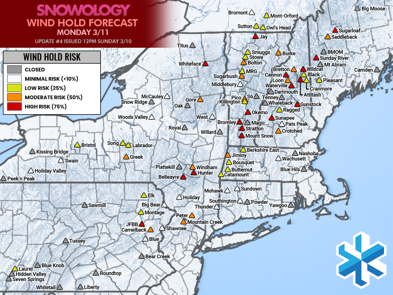
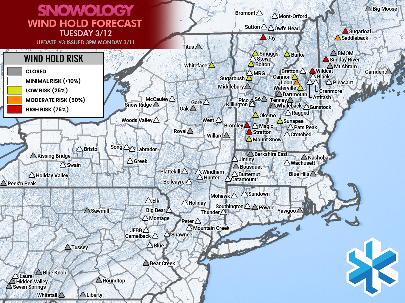
Wind Holds
Wind hold forecasts largely confirmed quite well, but as always there was some variability. Navigating the wind holds are critical to understanding how to enjoy the snow, and in this case some of our subscribers decided to delay their Sunday morning trips into parts of NH and ME so that they could miss the 3" per hour snowfall and heavy blowing snow that existed during the morning commute only to find mountains literally shut down from top to bottom. It's not risking your life, especially when there is no prize awaiting the early-bird. The pro-move was to arrive as the winds let up on Sunday and then to navigate around the following two days where wind holds were not as severe.
Here are the three final wind hold forecast maps for this storm. Guidance for timing and scope were provided with each forecast. These are done by probability and we did quite well on Sunday, and then also on Monday outside of PA, and Tuesday was more of a mixed bag in Vermont. I actually hope to have wind hold forecasts automated by next season so that late shifts are always reflected, but it's of course better to know 24 hours ahead with wind so that you can choose your destination before leaving of course.

When we claim to be the premiere skiing and riding resource for the East, SNOWOLOGY delivers! There's literally nothing else like it and I and the rest of our team work really hard because we want everyone to have the opportunity to be standing in knee deep pow after a safe drive and while the lifts are spinning, in a spot that doesn't get tracked out in 5 minutes. We hope everyone who is new to our coverage will stick with it for the entire year and beyond as it will only keep getting better.
Knowledge Is Powder!
-- Matt


Comments ()