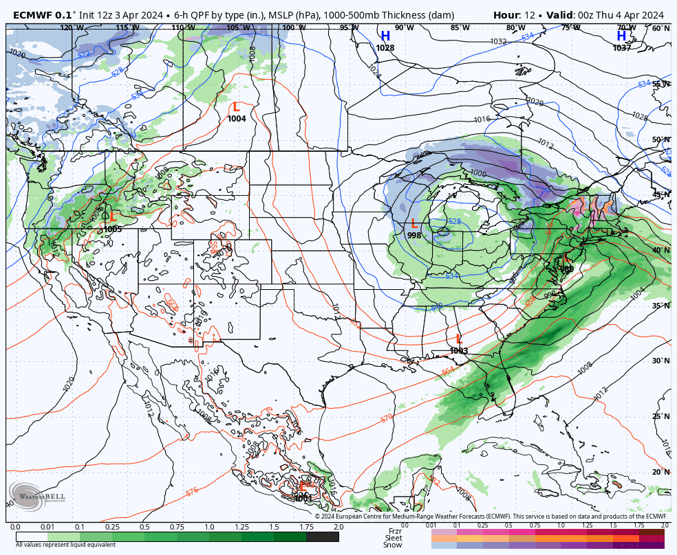
Today we are trimming, both the snow and the wind risk, but the focus here will be on Thursday's wind holds and I've tried my best to refine that for the pow hunters. Don't worry, we're still likely to see up to 30" in some spots by Sunday. Let's jump straight into the broad view from the ECMWF covering 8PM Wednesday through 8AM Sunday.
I'm going to first cover the Snowfall Forecast and then the Wind Hold Forecast. I've tried to refine the wind hold forecast as best I can for Thursday's pow hunters. Do however keep in mind that even if lifts might run at a ski area, there are going to be hurricane force wind gusts in some areas, especially on the leeward side of the mountains, and this will create issues with power and road conditions tonight through all of Thursday. Have a backup plan if you are hunting this because there will be power outages somewhere in New England on Thursday, and possibly even in NY.
Snowfall Forecast
Unfortunately mesoscale models have been shifting around as to how much moisture and what type of precipitation we will see overnight and into Thursday. If anything today we saw snow in some cases where sleet was modeled, but the real push doesn't happen until this evening. If things flip to snow significantly earlier than modeled then we'll see an overperform on total depths where that happens, but if they flip later than modeled we could underperform. That's always been the main issue here with this storm. In parts of N-NH and ME however, no mixing is likely and it's simply a matter of how much moisture there is. They will get hammered no doubt about it, but NY, VT, and S-NH are more so open questions. The back-end is primarily what looks more dry than before however we are not in the skilled range of mesoscale models to have confidence either way on the back-end.
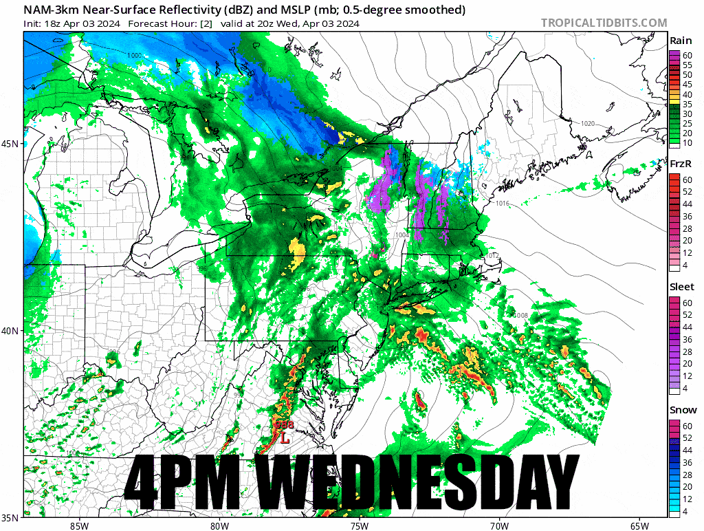
Let's start off with a simulated radar loop from the 18z (2PM) NAM3K covering 4PM Wednesday through 4PM Friday. This is useful for driving and it is timestamped for that purpose. My travel guidance is essentially unchanged since Monday evening. Thursday especially will be a tough drive both in the morning and in the evening, and generally speaking on Friday and Saturday we'll see some snow more broadly, but only around Portland, ME and close to the mountains will it likely be heavy.
Here's the latest forecast for the snow plus sleet accumulations. I did check the NWS forecasts also and in N-NY and VT they did bump last night to roughly equal my forecast, but they have already trimmed today based on the same shifts in the modeling that I'm reacting to. If anyone is disappointed about their favorite ski area, look at the calendar folks, this is a gift! Folks in Northern New Hampshire and Maine are still going to get super duper dumped on when the low stalls out on the coast and we'll see widespread 1-2 foot totals at open ski areas!
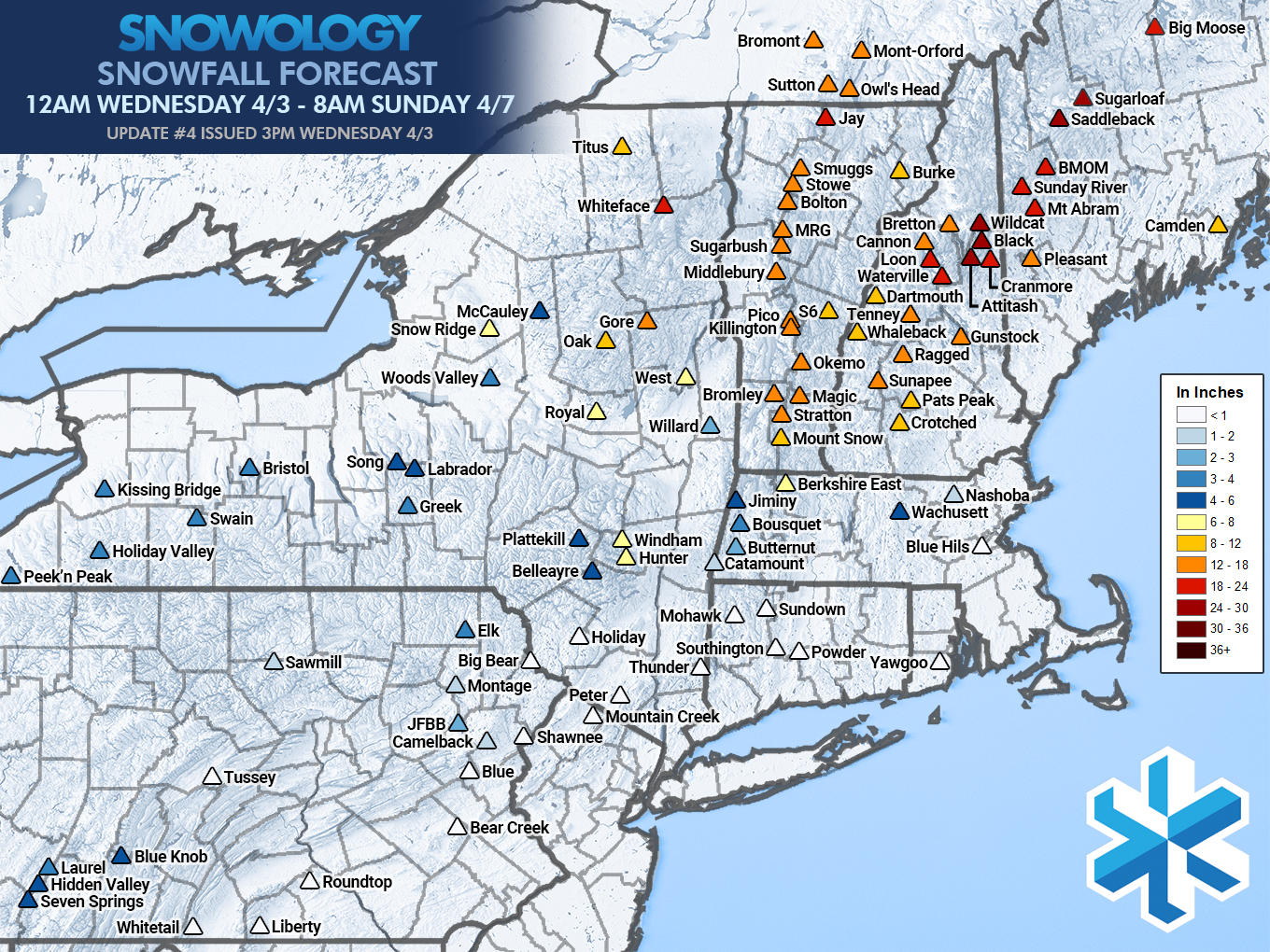
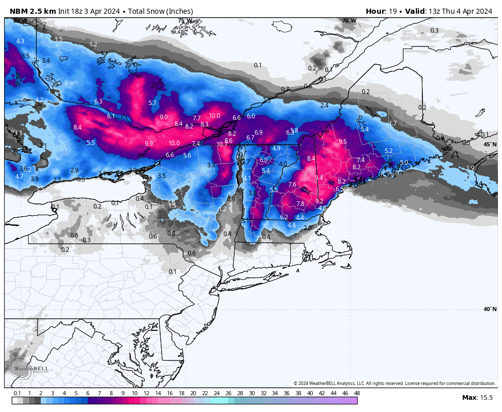
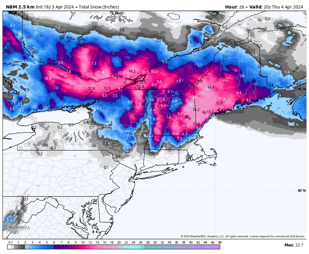
As far as snowfall goes, I'm going to use the National Blend of Models (NBM) to show how much depth will exist at open and at close on Thursday. The rest of the forecasted snow will occur between 4PM on Thursday and 8AM on Sunday with smaller accumulations by day and more limited in scope. This isn't perfectly accurate, in fact it may generally be a tad bit light on depth, but it's a good guide for those why are hunting this on Thursday.
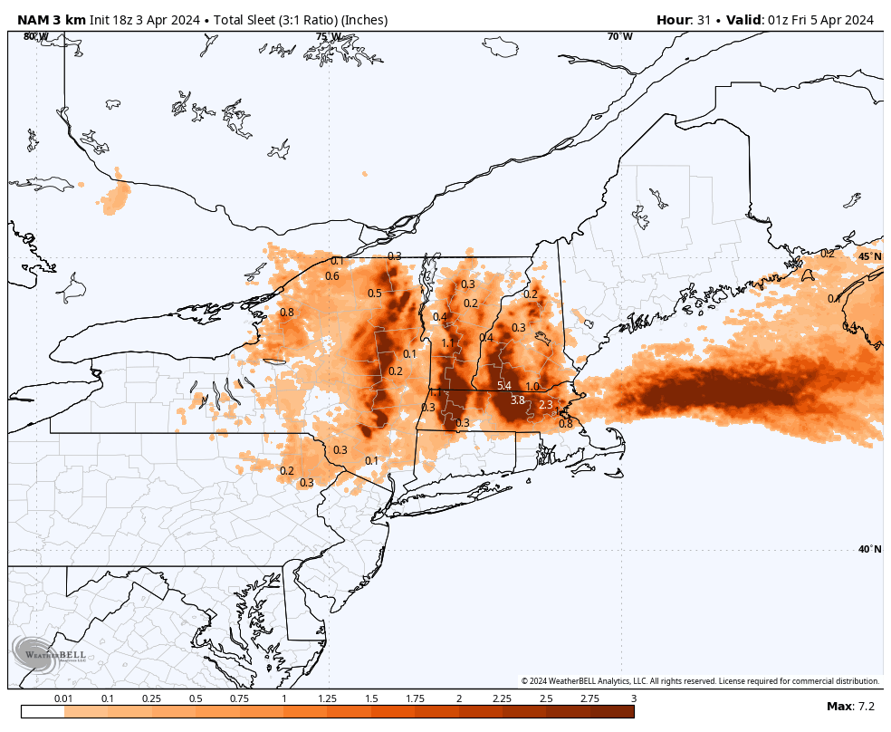
There will be significant amounts of sleet generally from the Gore/Killington latitude and south. There will likely be some areas with over 3" of sleet before the flip to snow, and forecasting will count that depth as snow (it's the NWS standard). This is what the NAM3K sees for sleet right now, but it is generally will show up to twice the amount that actually falls, though this scale peaks at 3" of accumulation and the model sees more than that in many areas. This is mostly good for determining the hot spots for sleet though, but the peaks in northern areas will almost surely see less than modeled. It's the broad areas of deep sleet where it will be concentrated. BTW, don't be scared of sleet, it skis just fine and it will be buried under the snow, but it is the worst type of precipitation to drive in! I'll try to track the flip to snow tonight on our Facebook page if it happens quickly enough to catch it.
Wind Hold Forecast
Wind on Thursday will be from due east and this will accelerate at the summits and then even more on the leeward side of the mountains (those that face west). Few actually face west though as north and northeast are colder aspects. In many cases lower lifts may still operate, but there will be plenty of upper mountain lift holds.
Forecasting winds on a summit is not an exact science. Stratton today for instance verified the modeling very well, possibly even exceeding it, but Berkshire East was coming in at just 1/2 their modeled summit wind speed in the afternoon. Wind is only part of the equation also.
Here's the updated forecast for Thursday that estimates where +25% of non-beginner terrain will be inaccessible by lift involve additional complication such as taking 2 lifts to lap, or long traverses, or even walking, though surely on a powder day that shouldn't hold you back.
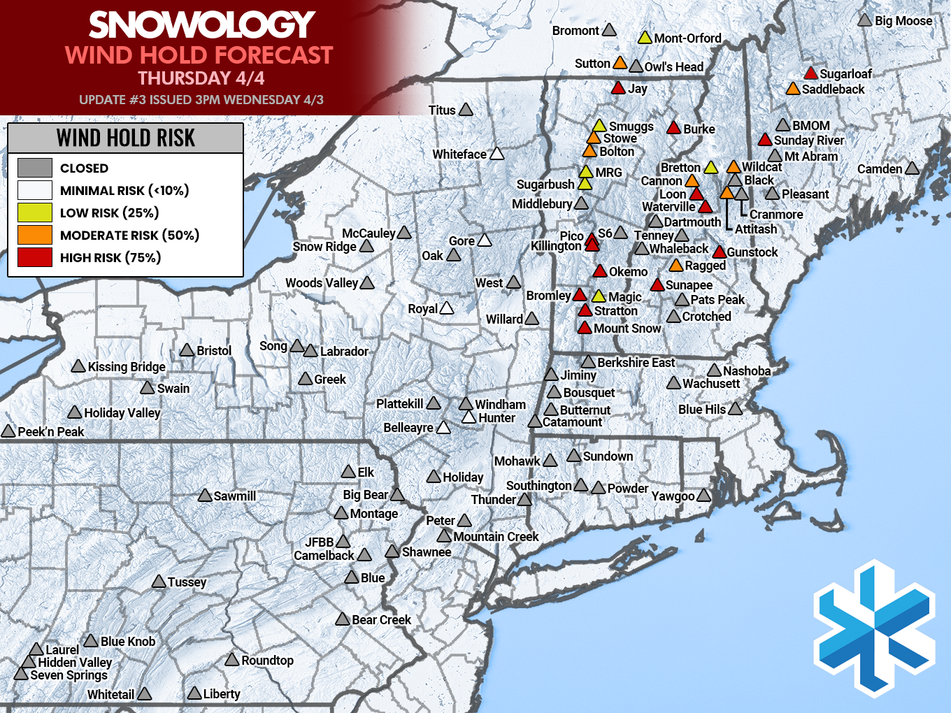
I've estimated the time when risk is gone for summit access in the following list as opposed to simply when less than 25% of terrain access is complicated or limited. These should be paired with the risk above, for instance Magic has a 25% chance of confirming a wind hold and that risk will likely pass by 10AM. Only those shown with increased risk are listed.
Mount Snow: Noon (worried about additional operational delays here)
Stratton: 11AM
Bromley: 1PM
Magic: 10AM
Okemo: 11AM (might run fixed grip to the very peak earlier)
Killington: 11AM (likely many aspects will run earlier than the peak)
Pico: 11AM
Sugarbush: 10AM
Mad River Glen: 10AM
Bolton Valley: 11AM
Stowe: 11AM
Smugglers' Notch: 11AM
Jay Peak: Noon
Burke: 1PM
Sutton: 11AM
Mont Orford: 11AM
Sunapee: All Day
Ragged: 1PM
Gunstock: All Day
Waterville Valley: All Day
Loon: All Day (likely only Kanc will run)
Cannon: All Day
Attitash: Noon (very uncertain about risk)
Wildcat: All Day (very uncertain about risk)
Sunday River: Noon (bubbles should run earlier)
Saddleback: Noon (very uncertain about risk)
Sugarloaf: All Day
I feel pretty good about the timing in VT and S-NH since I was able to verify today. I feel less confident about N-NH and N-ME. There will be some severe holds that limit access to more than 50% of terrain, but with low traffic you can probably make do in most cases and score some pow.
Now go out and get yourself some!
Knowledge Is Powder!
-- Mat


Comments ()