Thanksgiving weekend is a popular target for many of the most visited mountains in the Northeast to have at least a few trails in order to handle the surge of traffic during the holiday and it's also the start of the skiing and riding season in earnest. We've seen some enormous weather challenges so far this season and with the holiday weekend approaching it seems useful to talk about a few important things that are probably on a lot of people's minds right now. There's a lot here but it is all useful information for anyone who wants to ski or ride in the next 10 days.
I'm going to first go over the Incoming Pattern Change that will bring some extended cold to the Northeast starting next week, then I'm going to go over the Snowmaking and Opening Outlook, and lastly I'll go into detail about the Killington World Cup Outlook with a detailed discussion of the climate trends they are seeing and about passing snow control.
Incoming Pattern Change
We've had a warm start to the season no doubt with very few snowmaking windows thus far. Today there are just 3 ski areas open in the entire East with less than 50 acres in total. That's rough, and that's also not enough to handle the demand even when you add in others who have announced starting their daily operations within the next two weeks. Things are about to change though and while Thanksgiving weekend will be tight for for those who make it, snowmaking temps now look like they are going to start to return more widely on Sunday and Tuesday nights and come in force and more broadly beginning Wednesday night.
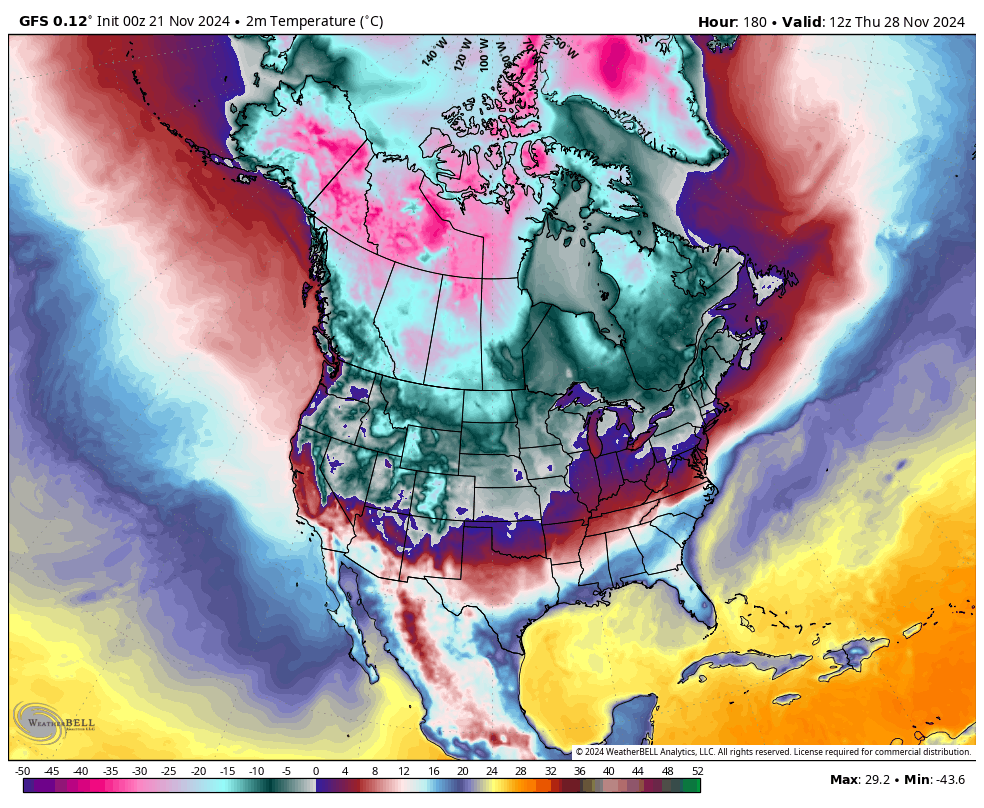
I feel pretty good about the outlook for next week but for the past week the GFS model has have been flipping between marginal temperatures and solid cold hits almost daily and the ECMWF hasn't barely seen enough cold until the Monday afternoon runs. I've been pretty worried honestly about what might happen in the warmer scenario if less than a dozen ski areas made it open with the most minimal terrain in the face of pent up demand during a holiday weekend, but this cold hit looks solid in the models now and lasting. That's a game changer.
I'm going to get a little technical here. As far as the underlying pattern goes, starting next Friday the 7-day 500 mb pressure (thickness) anomalies about 18,000 feet up in the atmosphere where the primary steering currents are point to an optimal pattern for both cold and stormy weather in the Northeast that currently has no signs of letting up in the models.
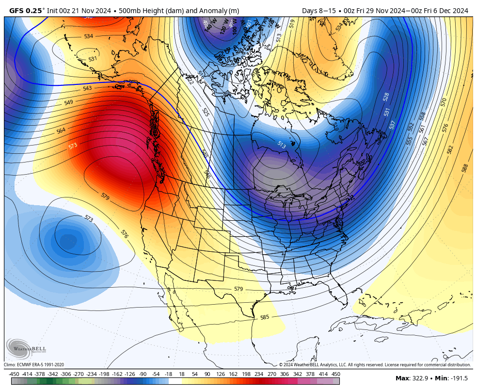
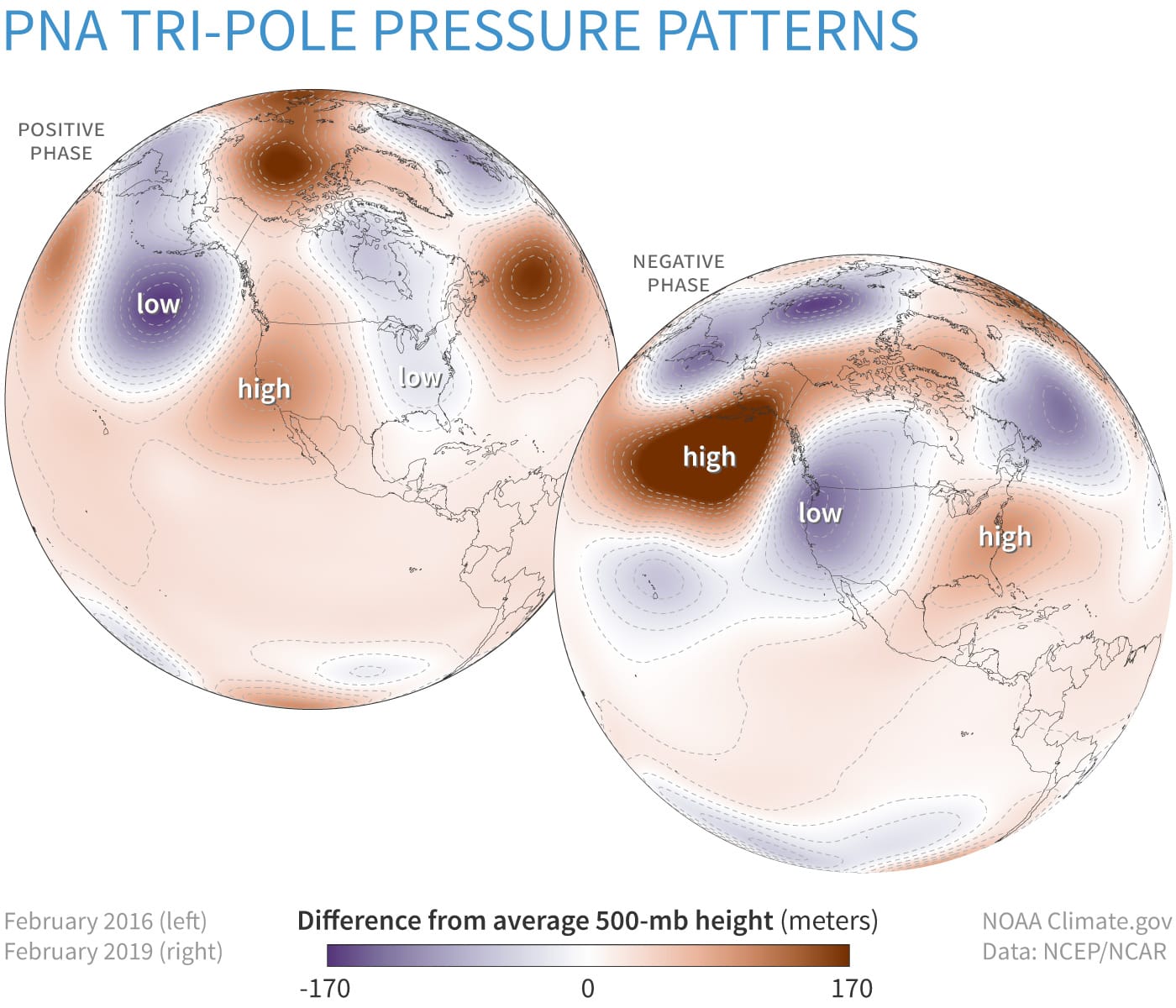
500 mb anomalies between November 29th and December 6th and the main phases of the PNA pattern.
This pattern is known as the positive phase of the Pacific-North American (PNA+) teleconnection/pattern. In normal English that means semi-persistent ridging (high pressure) near the West Coast which makes them warmer and less stormy, and semi-persistent troughing (low pressure) in the East which makes us colder and more stormy. Simply put, we are likely to catch up for the warm start to the season with rapid advances in open terrain and open ski areas starting next week, and possibly some coastal storms and clippers too. I can find no signs of this pattern faltering for the next 3 weeks in extended range modeling. Our mountains are going to turn from stick season to winter real quick.
Snowmaking and Opening Outlook
Starting Sunday night we should get snowmaking back online around the bases of some of the more northern mountains and things will improve as the week goes on. As a rule of thumb generally around 29F is where snowmaking production starts with modern equipment, though the wet bulb temperature is actually what determines this.
The larger mountains of N-NY, VT, N-NH, and N-ME where are targeting next Friday and Saturday have a pretty good shot at making it open if they aren't already, and those who are already open will be able to work on expanding terrain with productivity starting Sunday night and growing generally by the day. Here are some 7 day temperature charts from the NWS, but note that these seem a little warmer than the latest runs.
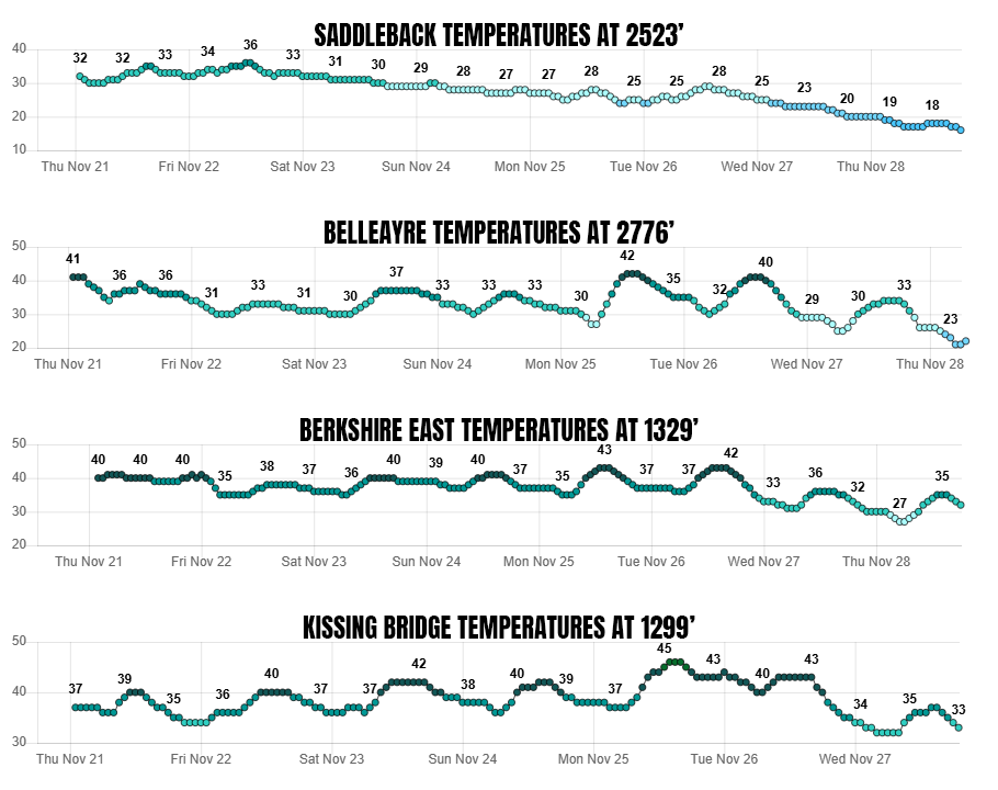
The Catskills are generally the next coldest in the Northeast and they might get some short marginal windows early next week before diving more solidly into productive temps starting on Wednesday. There's a chance of openings possibly as early as Friday especially if today's storm delivers there, and it very well may.
The Berkshires are probably next in line with temps production at Berkshire East looking possible on Thanksgiving, and you better believe they will do what they can to get open Saturday or Sunday if enough cold is there.
Kissing Bridge is close to Lake Erie which is quite warm right now and Thanksgiving isn't necessarily common to hit in that climate without the lake effect machine pointed at them, but by a week after Thanksgiving they could be open for business.
I don't want to list everyone who is open or is likely to open by next Saturday, but I believe that most who almost always make it open for Thanksgiving weekend will make it, though with less acreage than the average.
Killington World Cup Outlook
Yesterday in Storm Update #3 I discussed the possibility of turning lemons into lemonade this weekend should Killington not get FIS snow control approval and instead opened up that terrain to the public. I don't actually have any inside knowledge of where they stand on this as such things are pretty sensitive among staff and especially marketing departments so I try not to poke around honestly. I do know that if you do ask someone involved, the answer will exude confidence as long as there is a chance. It's literally a fighting spirit and theirs is among the strongest around, and expressing doubt only makes them try harder.
Killington's ops when challenged in the spring will take scraps of snow and spread them out across Superstar just to make June. It's not simply marketing, it's their damn mantra to rise to the challenge and operations will they push themselves to the delight of marketing. There's probably no trail in the world with more snowmaking capacity than Superstar, but they've only had one pretty good window in the middle of November and have been fighting temps whenever they can since then by pulling out the old K-3000 air hogs to steal some extra degrees and make snow at whatever elevation they can. They've had some nail biters since the World Cup came to town, all due entirely to weather, but this is going to be damn tight at best.
I've said a bunch of times this season that the Northeast has lost about 2 weeks of snowmaking in the fall, and that's based on the trends in first freezes, but I decided to take Killington's opening days for the last 38 years as a benchmark and chart it in order to determine the actual trend and I'm afraid it's way worse than I was expecting. It's literally one full month that has been lost!
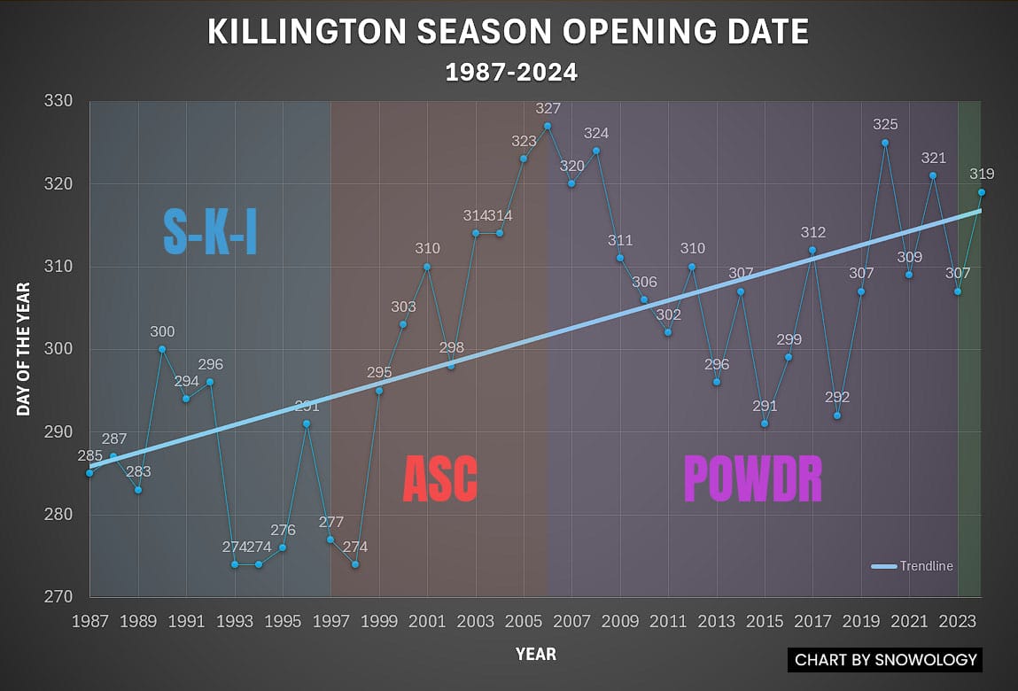
The trendline in 1987 shows opening and staying open for the season was October 13th but in 2024 the trendline sits at November 13th, a whopping 31 days later in just 38 years. There are other factors involved in this and I overlaid ownership to show how American Skiing Company (ASC) abandoned the aggressive early starts for a time only for them to return under POWDR, but that doesn't explain but a small fraction of the 31 days that has been lost. This is primarily the result of climate change of course and has nothing to do with effort and capability beyond the ASC years.
This year is actually the absolute latest that Thanksgiving occurs which is both on the 28th and also in a leap year, but it is the tightest Killington has been in reaching FIS snow control in all 8 seasons. We're warming in the fall, and more so on lows than the highs. So far this November Killington has averaged about 5F above the already inflated climate normals from the last 3 decades which only compounds the problem, and they're of course not the only ones dealing with that right now.
Last week Killington's snowmaking manager Greg Gleason gave an interview to Vermont Public Radio where he indicated that they need to make 4' of snow on Superstar in order to meet the FIS snow control (course inspection) standards for the race. That's a whole lot of snow of course. He also shared that the snow control date is the 21st, which is today!
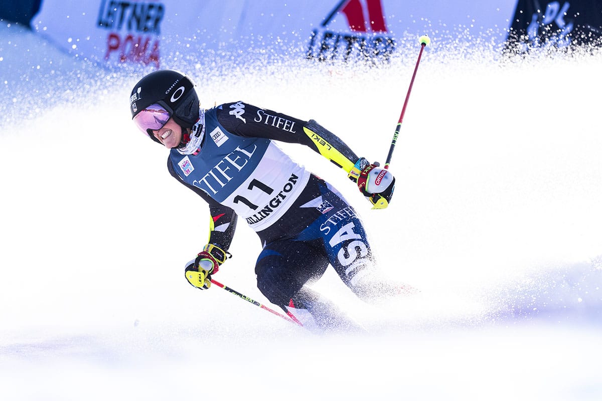
So here's what I do know. The FIS has given Killington positive snow control before when they weren't even finished making snow which shows how much confidence the FIS has in Killington's ability to pull this off when the forecast also supports it. Given recent model agreement on cold starting Sunday night, if they don't have it on the ground already, they probably can make it happen along with the other preparations if given the opportunity. I did do some searching around last week and generally snow control at Killington is further in advance of the race than the 9 days from today, but I did find positive snow control given as little as 7 days out for another venue in recent years. The FIS can approve them, fail them, or delay the decision. I don't know when time runs out though for having the snow prepared.
Killington was out grooming Superstar yesterday afternoon and that's a positive sign. I can't say one way or another if there is enough base from my desk but their temperatures have been pretty marginal for the last week there was less snow being pushed than I've seen in previous years. If there is not enough snow yet for FIS standards then it's for the FIS to decide what to do based on their confidence in both the forecast and Killington themselves while considering inflexible time constraints. If they are short on snow and the FIS gives them until Thursday there's near a 100% chance of success, but that is less certain in shorter time frames.
I do actually believe they are more likely to make it than not after really digging into it, and we might hear today whether or not they did. It's a big and important event for not just Killington but also for their local economy and race fans from around the world, so I'm always rooting for them. Maybe ring your cow bells today for good luck!
-- Matthew Scott

Comments ()