I'm not going to call this one a "Storm Update" although that's what it really is, it's just not the type of storm we're looking for with both r@!n and wind, and the back end snow looks like barely a booby prize. On the crap weather scale of 1 to 10 this one only scores a 5 and you can find dry weather and non-held lifts both days at dozens of ski areas.
This update is really an addendum to the Weekend Outlook that was published yesterday. I have better guidance for the timing of the r@!n, and also some wind holds to look forward to on Monday that will mostly correspond with the r@!n. As always we'll start out with the wide view to set this up, this time from the ECMWF covering all of Sunday and Monday.
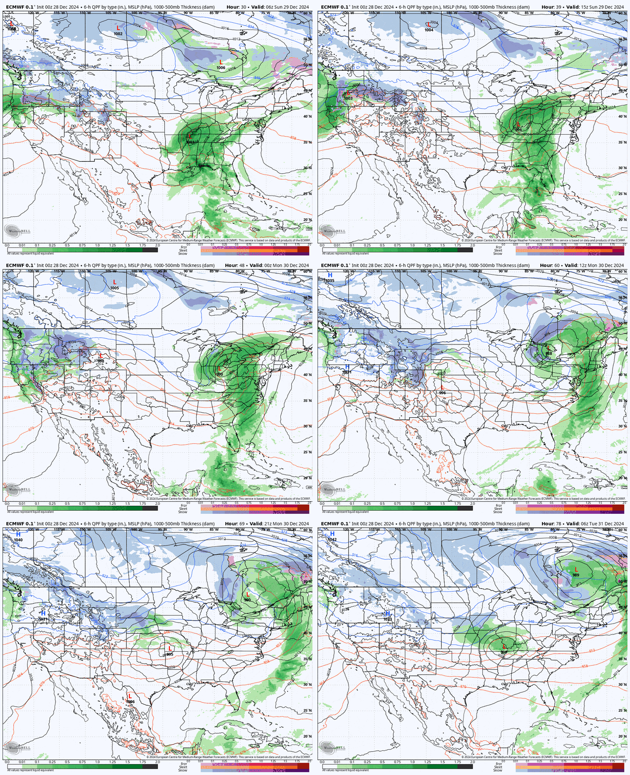
We've had a pretty good December as things go and the holiday so far has offered above average amounts of terrain for this time of year and even natural terrain open at quite a few ski areas, though that terrain is primarily too thin to survive much of a challenge. As Northeasterners are certainly used to the ups and downs and we will soon get another up. It looks like some will recover by the following weekend with the next storm similar to what happened earlier in the month with potentially days of back end snow! I'll put out something on that system later today.
I'll go over the Precipitation Forecast and break down the the timing of the r@!n on both Sunday and Monday to help you plan or dodge, and then in the Wind Hold Forecast I'll cover the impacts that are expected Monday.
Precipitation Forecast
I'm not going to get too fancy when talking about r@!n, and the focus here will be on timing, and the loops are timestamped in order to help with that. Models are in strong agreement but generally you should accuracy within +/-2 hours 24 hours out (Sunday), and +/-3 hours 48 hours out (Monday).
This is the NAM3K simulated radar covering daytime operating hours during Sunday.
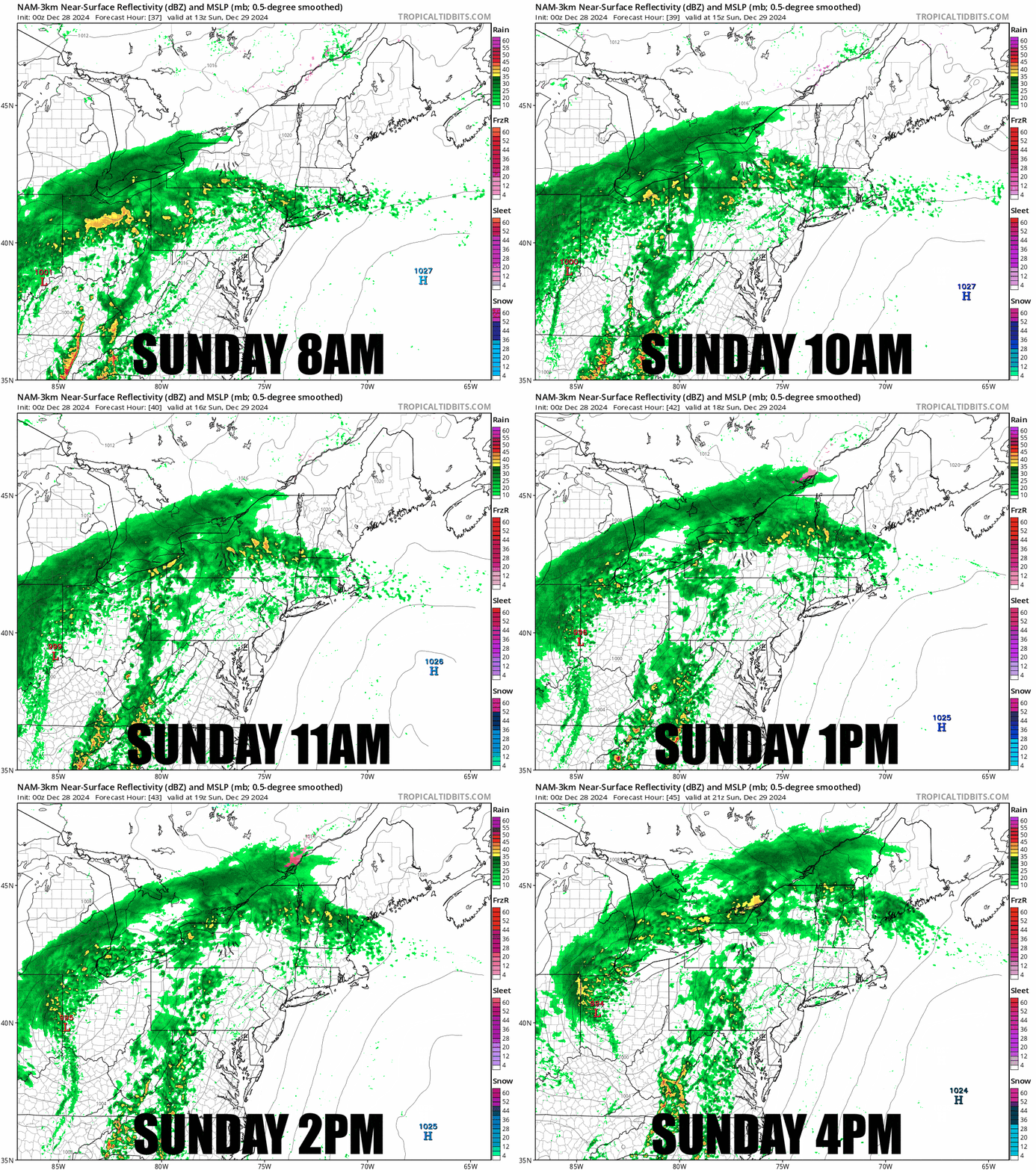
There is opportunity for 4+ hours of morning sliding in the dry weather in parts of N-NY, N-VT, N-NY, and ME with more hours of dryness as you move northeast. So my recommendation is of course to head north, start early, and break for lunch late after you nibble on your pocket snacks in order to make the most of the day. Things should in fact be quite good ahead of the r@!n, but this will be it for the packed powder for a few days or more.
I'm switching to the ECMWF model for Monday and this steps in 3-hour increments.
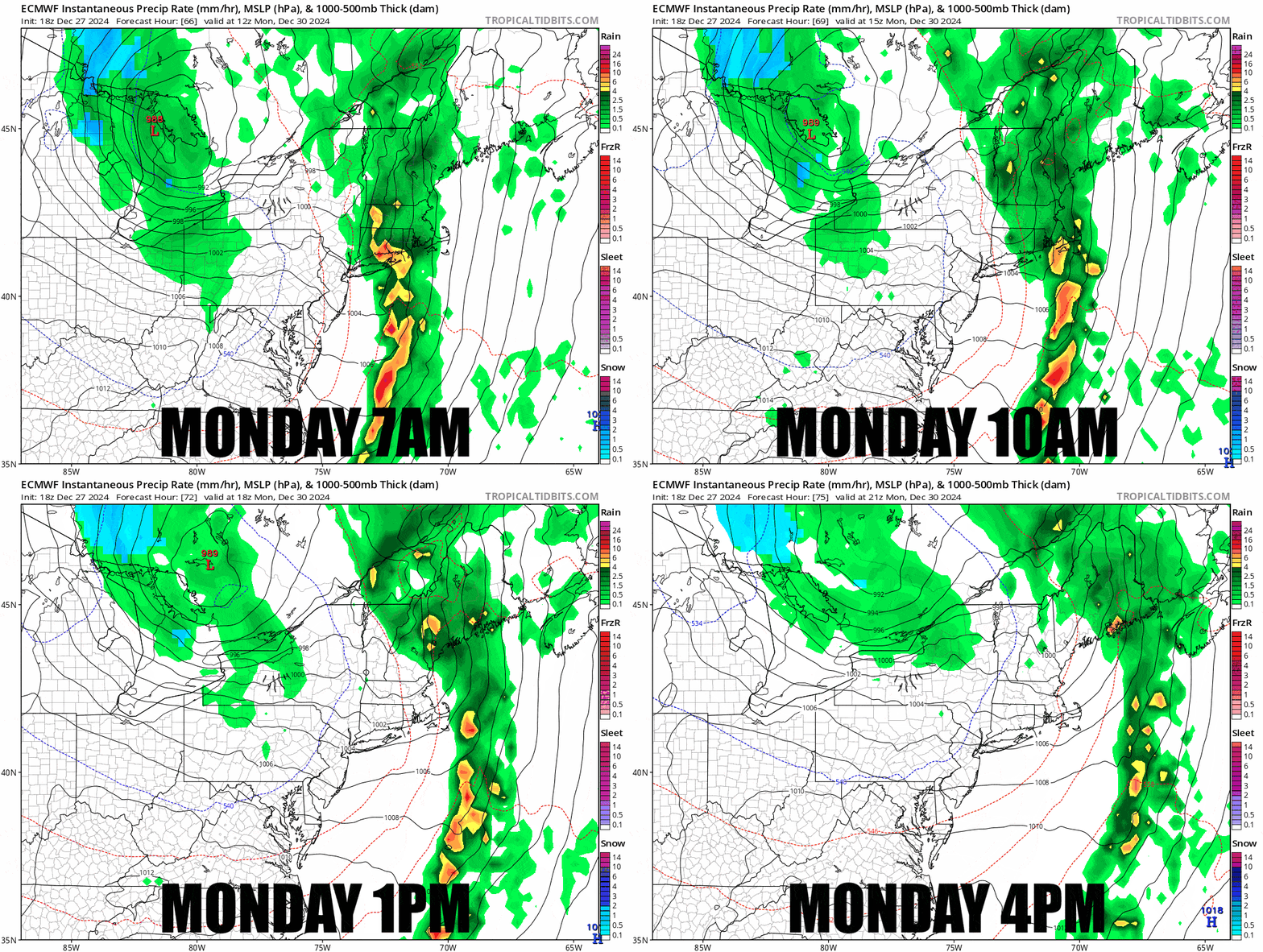
By open PA, NJ, NY, CT, and far W-MA should be dry and the wind should subside also behind the r@!n. That green stuff on the back end in NY is probably wet snow and likely not a concern.
Here's a loop showing the three major medium range models. I would lean more towards the ECMWF as the GFS seems to like to dump the water earlier on the upslope. We're talking generally 0.5"-1.5" in the mountains.
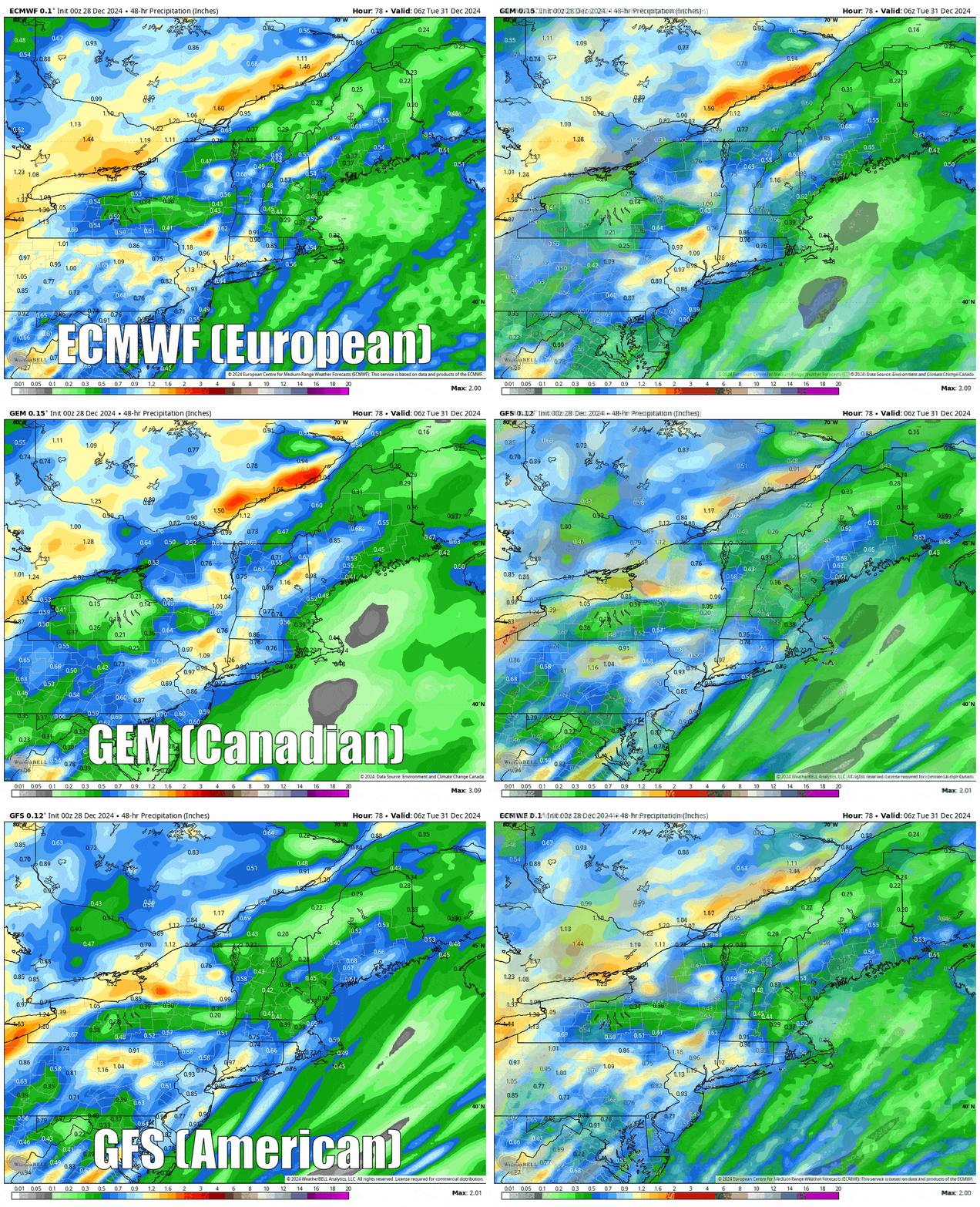
The good news is that while this is a cold front, a refreeze is not expected until overnight into Tuesday and almost everyone is expected to warm above freezing again on Tuesday so no need to sharpen your edges like kitchen knives on Tuesday for this one!
How bad will the damage be? Not that bad in fact. Most of the Northeast's rain will be driven by southerlies and the mountains that get the most from this setup tends to be the taller mountains that are first in line to get hit from the south, basically the same places that get walloped by nor'easters on the front end.
Wind Forecast
My concerns are exclusively on Monday, though on Sunday we will see some strong winds across PA and the western half of NY, just not to the levels that are likely to threaten lifts.
The loop below from the ECMWF shows modeled wind at the 850 mb level which is about 5,000' up, just higher than many of our tallest ski area peaks. The 850 mb wind is important for forecasting wind holds, and when we get into the browns, that means +50 knots (58 mph). The highest winds though are just above the tops of the first mountains they hit and those winds can come in at different levels, so we'll see most lifts untouched but exposed and otherwise more vulnerable upper mountain lifts on peaks taller than their southern neighbors is where you will find most of the trouble.
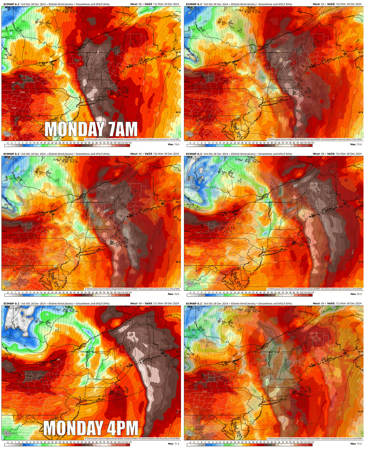
BTW, I'm not sure if credit for looking at this view for wind gusts over surface level modeling should be given, but I learned this from an NWS meteorologist with a keen eye for accuracy, and I respect that of course. I've found that many meteorologist like to share their knowledge and and even methods at times. It's better than discussing crappy wind holds of course 😄
Because this is southerly wind and the angle of approach matters a lot with shielding, my confidence goes down as you move north deeper into the mountains, in this case the Greens. My confidence is higher in some other circumstances also. Cannon has a notorious notch funneling problem from the south that is angle dependent but likely to trigger, and Saddleback hates southerly wind for the same reason it loves snow from the south, the wind wraps over the south side of the mountain and down onto the north. On the other hand they both fight wind hard and tolerate it well when wind comes from the northwest. It's not snow this time, so no big deal.
I'm not going to detail the timing until the Sunday morning update, but the loop above will show you the expected timing where the browns are the threat. Areas of S-VT should clear risk first and this moves northeast as the day progresses. I've actually lowered the risk in S-VT based on the wind possibly clearing faster than modeled, which does affect probabilities. I wouldn't avoid S-VT on Monday, but you may have some delays in the morning is what it looks like now.
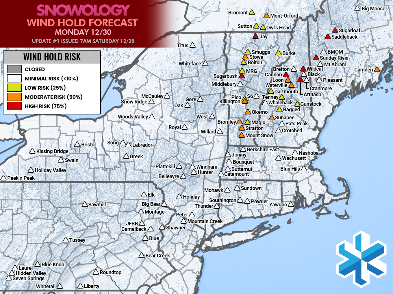
Wind hold forecasts confirm when access to +25% of non-beginner terrain limited or complicated for 2+ hours. On busy days this can also cause lift lines to back up, though I don't expect Monday to be that busy where wind will be an issue due to the r@!n. Lifts that reach near the summit are at the most risk and lower mountain lifts are rarely held outside of severe events or special circumstances related to terrain focusing the wind.
Knowledge Is (Not) Powder (This Weekend)!
-- Matthew Scott


Comments ()