Let me put this bluntly, the storm looked kind of nasty yesterday, and it looks even nastier this morning. Outside of PA the best day of the holiday week may be Saturday so make the most out of it.
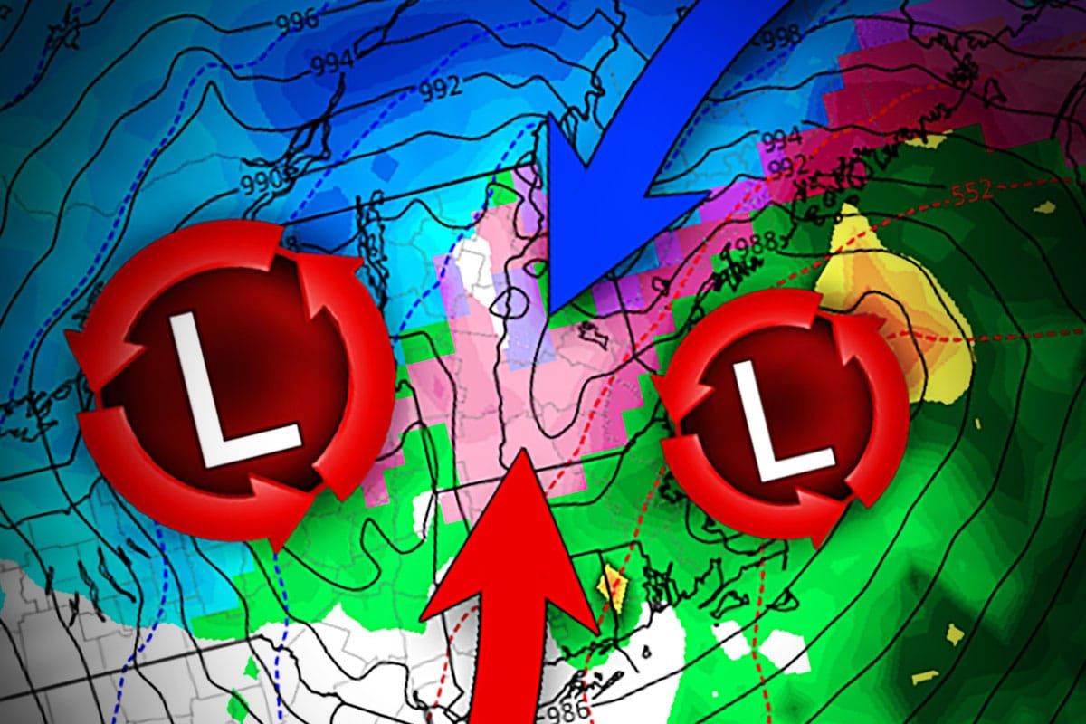
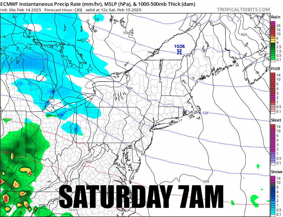
We have a cutter, a storm that tracks up through the Great Lakes, in this case cutting through WNY. That cutter will likely (not guaranteed) form a second low in the Gulf of Maine and transfer energy to it. This setup is known as a triple-point low and only the Longfellows of Maine (as well as Quebec) tends to love most of these storms but it creates a mixed bag of all sorts of stuff elsewhere in the Northeast.
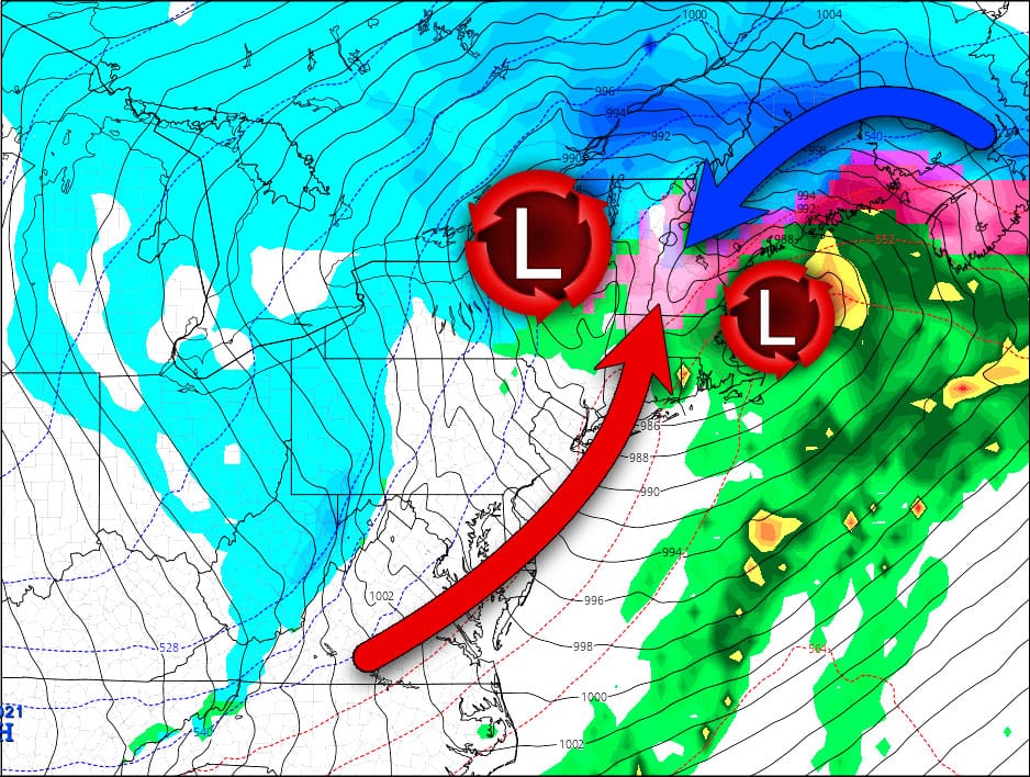
That cutter low pushes moisture and warm air out in front of it but when the secondary low forms off the coast where an occluded front, a warm front, and a cold front all meet (the "triple point") it helps push cold air south to hold off the advance. This typically creates a large battleground of cold and warm air, and with that sleet and freezing r@!n.
Now if you are watching your weather apps (absolute garbage for tracking Northeast storms honestly) you will likely see some big changes from run to run for a location, but the issue is that small changes in when that low makes the jump to the coast will cause major changes at many locations in what type of precipitation falls, and how much of it falls. I can tell you that models often struggle with nailing down this jump to a secondary low, and they are struggling now. The trend is not good if you love snow, and as we already know there are strong winds and cold air behind this system that will cause lift operation issues through at least Tuesday. This is going to be tough for many, and while I can't influence the weather (our weather modification Kickstarter failed to reach our $50 billion goal) I can at least help prepare everyone for what will happen so that you can plan accordingly.
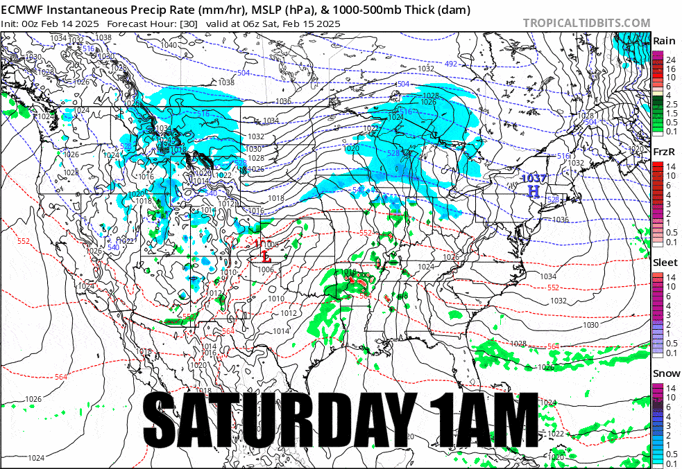
So here's the broad view from the latest ECMWF covering all of Saturday through Monday to get things going.
I'll be covering the Precipitation Forecast, the Wind Hold Forecast for Sunday through Tuesday, and lastly the Travel Forecast for Saturday and Sunday. I've decided to not split out the Monday and Tuesday coverage because there isn't a lot of snow on the back end of this system so that coverage will mostly focus on the wind.
Precipitation Forecast
We'll start off with the best damn snowfall map for Northeast skiing and riding. This map shows the extent of the r@!n, freezing r@!n, sleet, and snow, and it also shows where I believe there is potential of lift and terrain holds due to icing during Sunday (most will not confirm but likely will see freezing r@!n both just before and during lift hours).
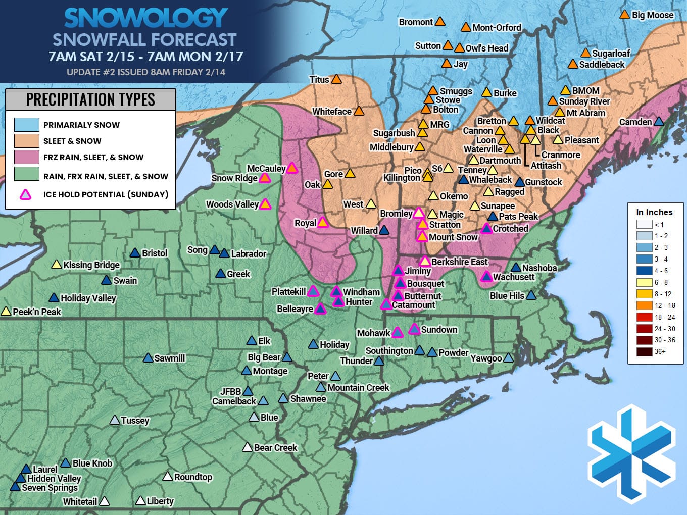
To say this is complicated is an understatement. We'll have precipitation falling for about 48 hours starting on Saturday as the pre-storm approaches from the southwest, and then tapering off early on Monday morning as the low scoots off through the Maritimes. People often get confused about how much snow to expect at a given time when presented with a full storm map like this. Simply put, some places will start as snow, transition all the way to r@!n, and then they might even flip back to snow again on the tail end while others will just simply snow all the way through but the snow will fall across up to 3 different calendar days. Non-snow will also affect their measurements but I can't adjust to the variable reporting standards of the ski industry in terms of time and technique.
This loop shows what the ECMWF is seeing currently but take note, the ECMWF loves freezing r@!n over sleet, but I feel moderately confident that sleet will be the predominant type of mixing between the two.
Pay careful attention to the loop. It should give you a good idea of what to expect to be falling from the sky at a given time (except that the ECMWF has a freezing r@!n bias over sleet).
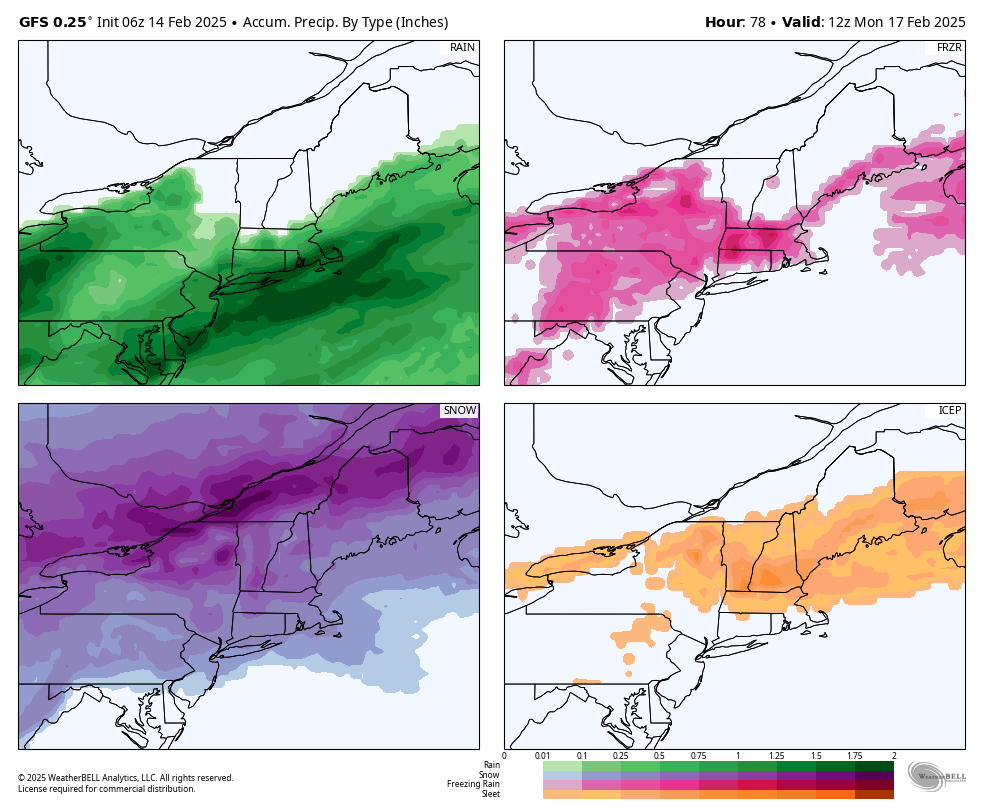
As far as surface conditions go, freezing rain forms a glaze over the slopes and doesn't damage the snow underneath, and after a groom on Sunday it will ski just fine, though a bit less smooth than packed powder of course. Sleet doesn't damage anything, it's just granular ice pellets that will fall into the snow and while it absolutely sucks to drive on, it skis perfectly fine. You will find the best ungroomed natural snow conditions during the holiday week where things only transition as far as sleet. This will cause some conditions issues though where rain falls more substantially and doesn't transition back to snow but those areas will generally be south of the Albany, NY latitude, and with the exception of WNY, WPA, and close to the Atlantic coast, there isn't a lot of r@!n. Here's a map from the latest GFS showing all types of precipitation to help you gauge the distribution better.
The bottom line is that this is a very tricky forecast and if I nail it widely from this distance that will involve some luck. Expect some changes and continued uncertainty for single points near the changeover zones! I believe natural ungroomed terrain will be just fine in the ADKs, Northern Greens, much of NH and ME for probably the entire holiday week, but we do have wind to contend with and Mother Nature is going to be feisty with this one.
Wind Hold Forecast
Never, ever, ever hunt just the snowfall map in the Northeast! You have to understand the temperatures, the other types of precipitation, and most importantly the wind! Now I know that many people are going to be holed up for the weekend at a given location and it's not a great time to go hunting pow because of holiday crowds, blackouts, etc, (unless you go for the sleepers) but at least you can maybe plan your days better by being better informed.
Saturday there are zero wind hold concerns (icing could come into play in W-PA), but on Sunday we do have wind with the storm to contend with, and on Monday and Tuesday we have some very strong wind on the back end that will cause some severe holds where more than 50% of terrain will not be accessible. Wind probably will no longer be an issue by Wednesday but there is a chance of some issues around Wildcat and the Longfellows Wednesday morning and I will forecast that if so.
We'll start off with Sunday. The problem is primarily southerly to southeasterly flow associated with strong cutter traversing NY during the day. I have less confidence with this sort of setup. The threat will generally be all day on Sunday in VT from Mount Snow to Sugarbush, but by the afternoon the others with increased risk levels may begin to experience holds. The mixed precipitation in the Southern Greens will make ski areas more prone to going on hold and I see potential of severe holds primarily at Mount Snow, Bromley, Okemo, Pico, and Sugarbush.

On Monday we transition to back end wind coming from the west to WNW. These are generally much easier to forecast, however we are not in range of the models with better resolution yet so expect some changes. I tend to err slightly conservative at this distance. Wind looks like it may peak at about 11AM and remain that way for the full day. Unfortunately the map is lit up like a Christmas tree and I've been warning for many days that Monday and Tuesday will be very problematic. There is severe wind hold potential everywhere that shows high risk, and there is also potential among those with moderate risk as well as even low risk ski areas with one main lift. Let me put this bluntly, Monday may widely be the windiest day so far this season.
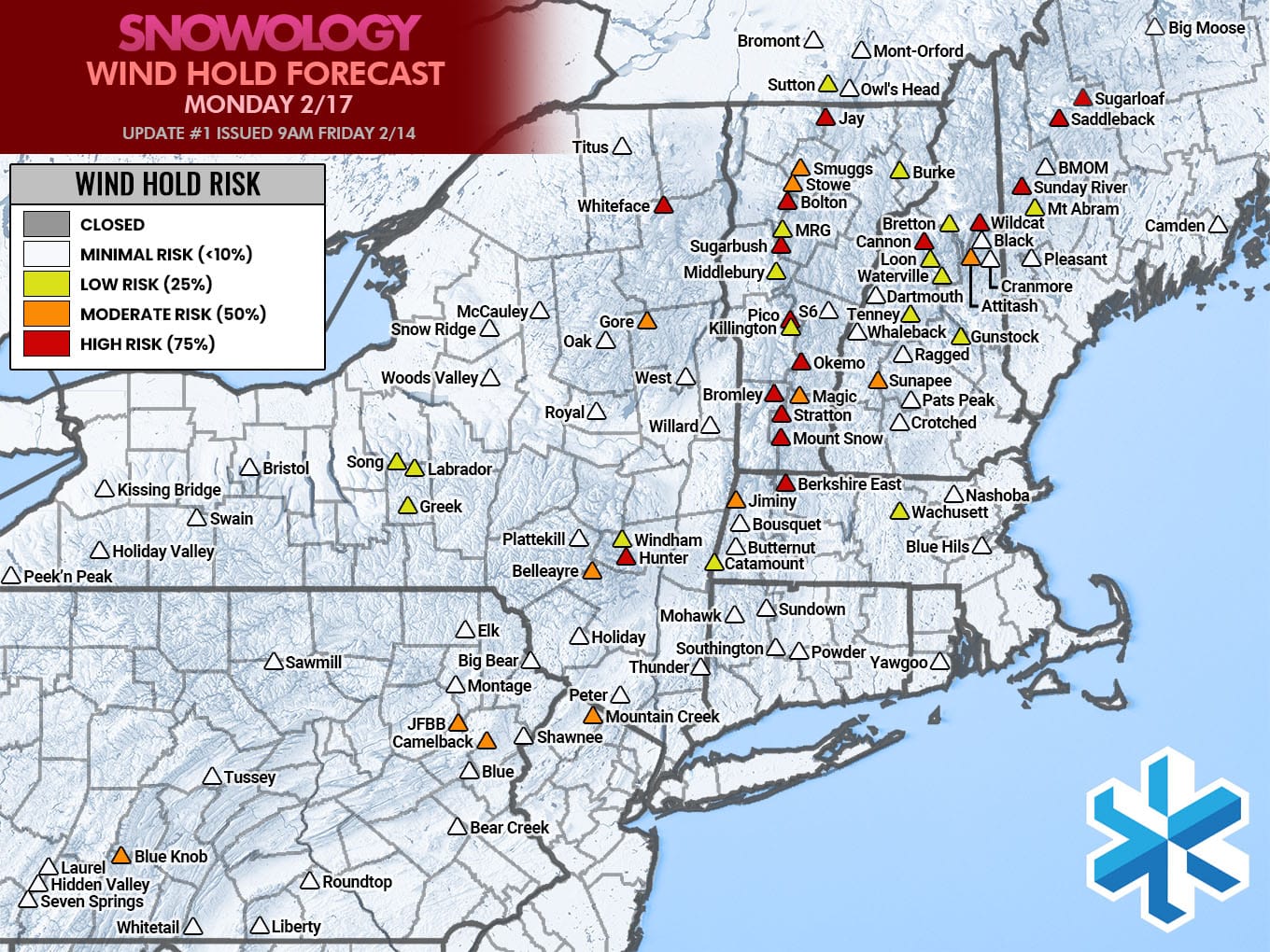
On Tuesday as the storm pulls further away the wind will let up somewhat however there will still be widespread issues and the intensity will remain in parts of the Whites of NH, and the Longfellows of ME where there is risk of severe holds as well as in parts of the Southern Greens.

Travel Forecast
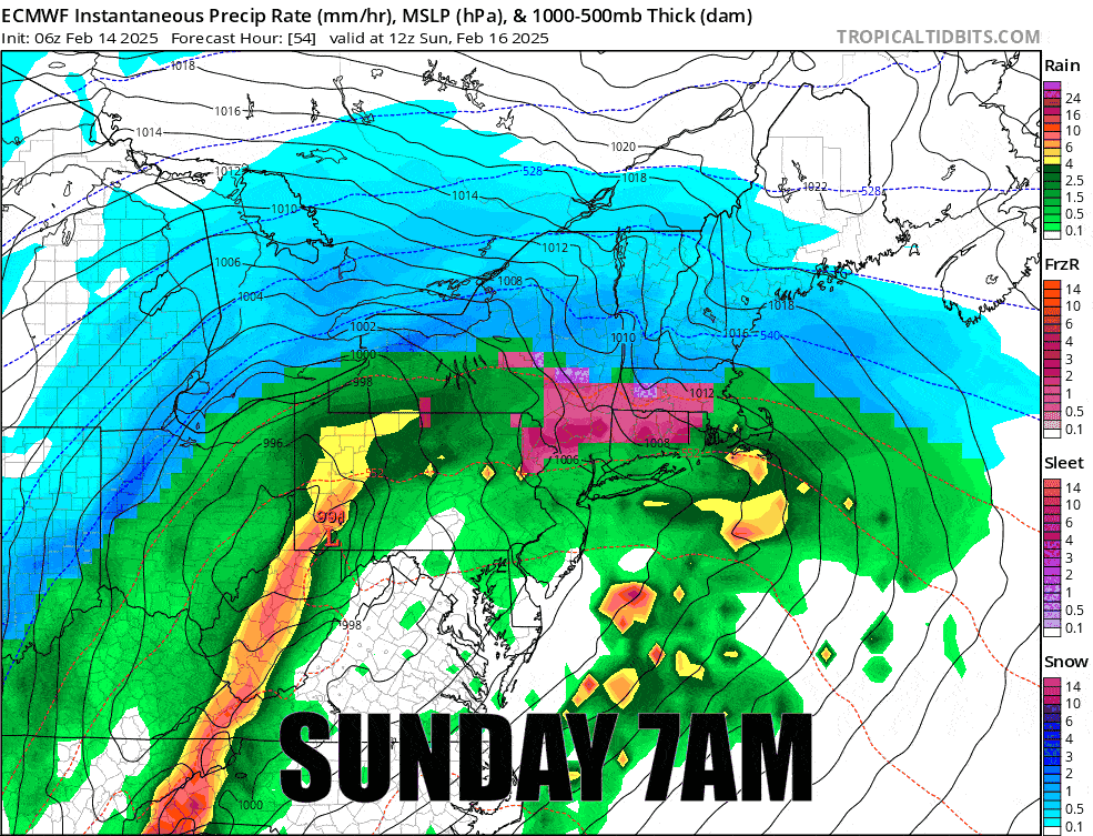
Since this storm is bringing a mix of precipitation with large swaths of sleet and freezing r@!n in addition to the snow, I'm going to stick to simulated radar and precipitation intensity maps as they show all forms of precip.
We have three main travel windows that are likely to be notably impacted starting with Saturday evening, then Sunday morning, and Sunday evening.
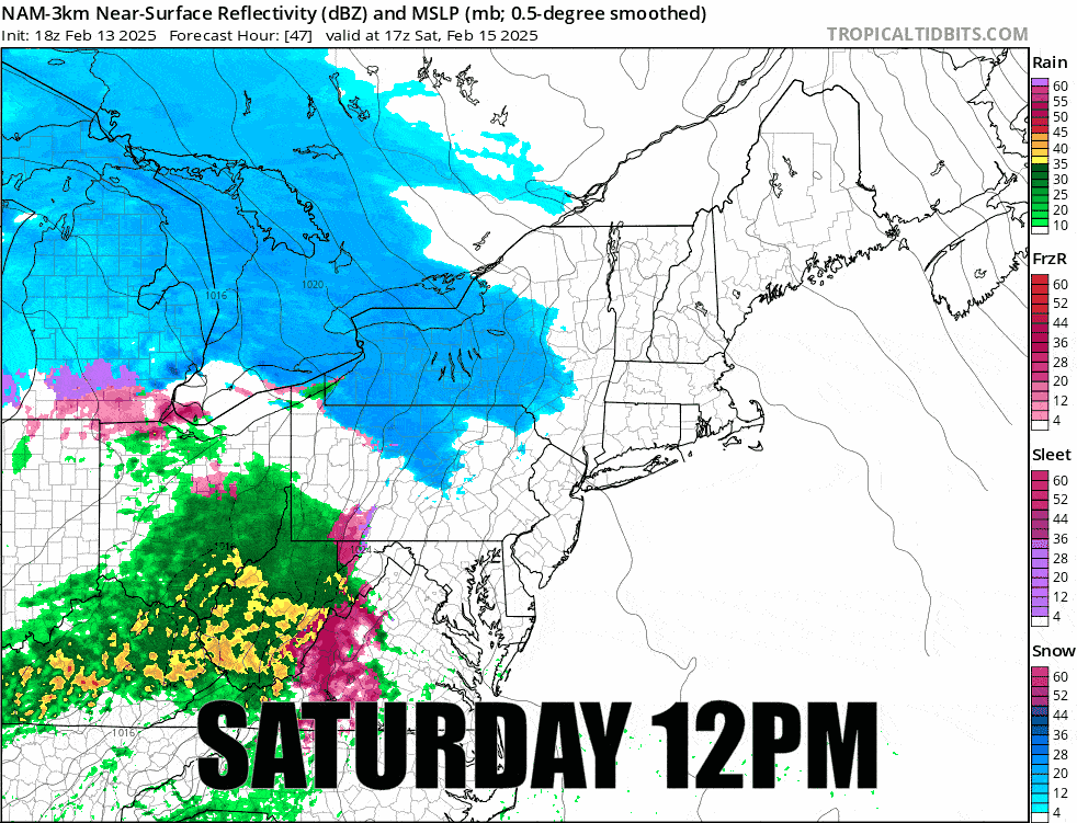
We do have simulated radar covering Saturday. The snow will be generally moderate in intensity in this leading edge (the real storm is still off screen), but in parts of NY, NJ, and PA you will have to contend with some sleet and freezing r@!n, and sleet is the absolute worst to drive in.
Things generally go south by Sunday morning with moderate to heavy snow expected along with moderate to heavy sleet and freezing r@!n. The entire day is going to be bad to extremely bad for travel across much of the region. I recommend against travel on Sunday!
Knowledge Is Powder!
-- Matthew Scott


Comments ()