
The last day to use your 20% discount at SkiEssentials as a Snowology subscriber is Saturday, February 28th. This discount applies to all 2026 or regularly priced products.
Sunday is the start of meteorological spring, but it isn't by far the end of ski season, and I truly believe spring skiing is by far the funnest and most social time on the mountains. We have 3 more months of skiing and riding left in the Northeast and I highly recommend experiencing this part of the season first hand if you haven't.
The Ins and Outs of Spring Skiing and Riding
I love spring skiing and riding not just because my workload drops and I can make it out more, but also because the temps can be comfortable when the corn is plentiful, people break out their grills and hang on the patios without their jackets and swig some brews with their friends. It's the most social time of the season.
Mountains tend to have a lot of events in March also to help keep people coming back. Big storms do tend to happen in March to reset conditions, but unlike in winter the pattern generally produces warm ups following those storms so you have to time it right. The freeze and thaw cycle also means you have to hunt the temps and at some point the warm days are the better days to be out. Spring also means school sports start on the coasts in just a couple of weeks causing families to pack up their snow gear and when the grass starts growing in the warmer areas many stop thinking about hitting the snow, but that only means shorter lines and the powder stashes when they come last longer (unless you group-think it).
Medium to large sized ski areas do start to shut down generally in March, beginning with Pennsylvania and into parts of New York and Southern New England. The Catskills and ADKs, Greens, Whites, and Longfellows generally last into some point in early- to late-April. Then we have the late closers and the list is thankfully growing.
This season Camelback is targeting early May in a continuing effort to win back their fans after some lackluster seasons. Black Mountain of NH will surely be back at it again after making it into May last season and I would expect the same effort again. Sugarbush typically goes to the first weekend in May, Sugarloaf maybe the second week if the snow holds up, and Jay Peak can also go to the second weekend in May or later. Then we're generally left with Killington who targets the first weekend in June and Sommet Saint-Sauveur in Quebec will try also, but typically they make it to mid to late May.
Temps in spring can change the timing of the closures and either extend to decrease them by 1-2 weeks when the spring is extra cold or extra warm. Snowpack matters too, whether it is natural snow or the denser manmade stuff that is underneath. We're doing pretty good in New York, Vermont, and the Northern Whites as far as natural snowpack goes, though it is less dense due to the consistent cold we have experienced which means it will melt faster when challenged by warmth and r@!n. Let's hope for some nor'easter refreshes which can happen as late as mid-April though with less frequency by week, but for the next two weeks that is unlikely to happen.
The Corn Horn Starts to Blow Widely Next Week
Now if you are on Facebook or you watch weather people on YouTube, you probably already know that a huge fissure in the Earth is going to open up and warm the Northeast to 1 million degrees by March 10th. It probably won't be quite that bad though. Please remember that when your home on the coast hits 70F, the mountains up north can still be in the 40's or even below freezing. Also remember that those people sharing a maps with big arrows and large words tend to hunt for the warmest model run they can find because it gets them clicks. They generally show the most extreme thing they can find. They'll use kuchera snow maps to inflate the snow, wind chill maps to make it seem colder than it will be, and heat index maps to make it seem hotter. This has grown so severe on Facebook that it is actually hurting ski areas by turning people off. We're likely talking millions of dollars in business in fact.
Here's the reality. Our dominant and optimal winter pattern of northwest flow from a PNA+ pattern with ridging in the West and troughing in the East changed a couple weeks ago to more of a zonal flow with active weather but more marginal temps. Starting later next week following what looks to be a decent slider in the northern half of the region we will transition into a notably un-wintery pattern with a deep trough mid-continent and persististant ridges of high pressure just off the West and East Coasts. This is what the GFS ensembles show for upper level pressure anomalies in the second week of March. This is a dominant pattern that isn't associated with a single storm and at this range dominant patterns tend to hold up.
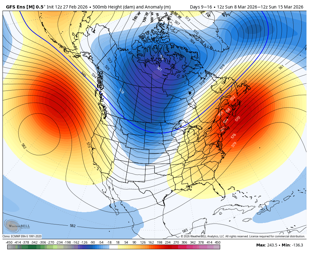
While the reds and blues don't represent temperatures, they are often analogous to them. Ridges south of the Polar Jet Stream bring warmth, and troughs north of the Polar Jet Stream bring cold. If you follow the lines of constant pressure this represents the general direction of wind flow in the upper atmosphere, and southwest flow into the Northeast isn't conducive to snow or cold. The only saving grace to this pattern is that it's happening in early March with lots of snowpack which will help moderate the effects in the northern areas, at least to start, but it's going to be pretty bad in the southern half of the region no doubt.
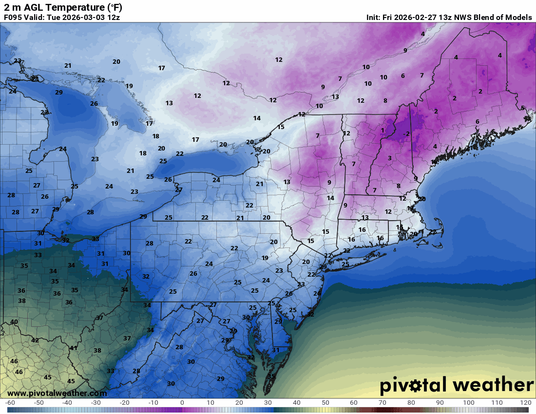
I have temperatures from the National Blend of Models from Tuesday of next week through Monday. This warm air intrusion will slowly build, but we will likely start to torch somewhere around the following Sunday.
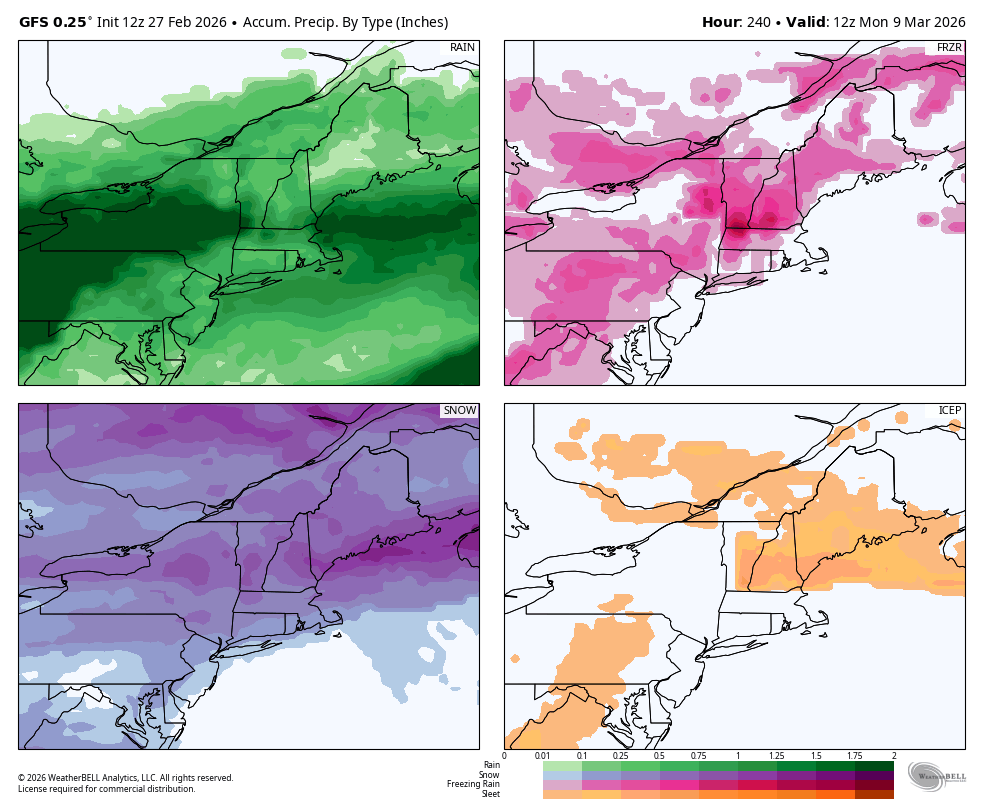
Now this pattern looks quite active with 6 waves of precipitation in the next 9 days, and progressively warmer. While none of these storms looks really bad, we could see up to +3" of r@!n in some parts though the northern areas will transition more slowly. Cold air tends to hang on the longest in the Longfellows of Maine through a process called cold air damming. The Northern Whites hang on the second longest, and then into the NEK of VT and then the Northern Greens, ADK's, and Southern Greens in that order. These areas will be less impacted by melting, but everyone will see melt. Here's what the GFS shows for precipitation types and amounts through Monday morning March 9th.
This pattern might start to break around March 12th. If that trough then shifts east then this could set us up for some nor'easters, but we're talking fantasy range for predicting storms and I don't have strong confidence that it will shift then, but I do have some modeling suggesting that along with hope.
Melting of snowpack is by far the worst when things don't refreeze at night and we'll see a lot of that for up to a week or more. So this will be a bad melt, but this happens every March and the ski season is far from over. The best part is yet to come. In the meantime, expect a lot of unsettled weather and progressively non-optimal precipitation next week.
Knowledge Is Powder!
-- Matthew Scott


Comments ()