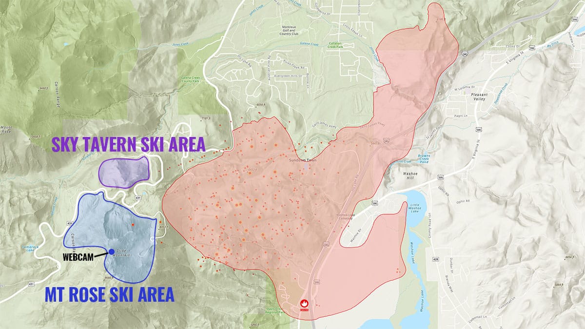
On the evening of this last Saturday September 7th a fire started in Davis Creek Regional Park in the Lake Tahoe region of Nevada just 2 miles west of the summit of Slide Mountain where the 1,200 acre Mt. Rose ski area is located. Within 24 hours the fire had grown to 5,000 acres (updated estimate from Monday evening) under red flag warning conditions as it crept up the mountainside towards the ski area as well as north-northeast towards more populated areas in the Washoe Valley just south of Reno. Just north of Mt. Rose also lies the nonprofit 4-season Sky Tavern ski area which serves the greater Reno, NV region which is also under significant threat. Mandatory evacuation orders issued Sunday afternoon covered all of Sky Tavern and the majority of Mt. Rose as well as much of the valley below.
The Perimeter of the Active Fire Has Not Yet Crossed into Either Ski Area
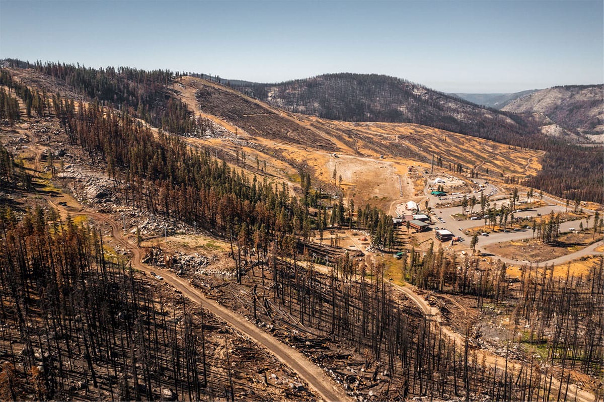
Despite satellite detection from 2AM Monday morning showing hot spots within the perimeter of Mt. Rose and afternoon radar indications of heavy smoke emanating from near the Winters Creek base on the backside of the ski area in the afternoon, Mt. Rose marketing director Mike Pierce provided a statement to SAM Magazine earlier on Monday indicating that the fire was still beyond the boundary of the resort. Snowology also reached out to Greg Gavrilets, the general manager of Mt. Rose, and was advised that they would release another statement at a later time as more details emerge in the coming days.
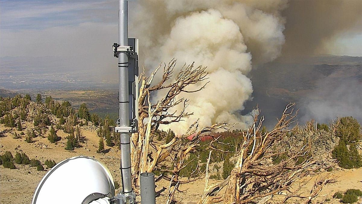
Monday evening's update of the fire's perimeter confirms this statement, showing the estimated boundary just 500' away from the Winters Creek Lodge at Mt. Rose, and bordering the Mount Rose Highway adjacent to Sky Tavern. Indications of fire do exist beyond this perimeter and within the footprint of both ski areas according to NASA's FIRMS satellite imagery but are likely the result of "spotting" when embers carried by the heat of the fire and then dispersed beyond the active region but neither active or spreading.
The Cavalry Have Now Arrived from the Air
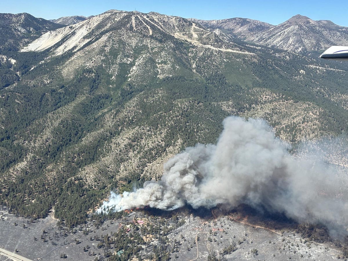
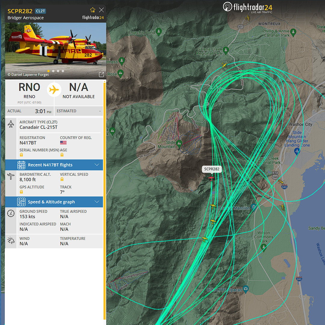
Later on Monday the cavalry arrived when four SCPR282 'super scoopers' joined the 3 helicopters already working the fire. The 4 planes have been flying loops between nearby Lake Tahoe and the boundary of the ski area dropping water in rapid succession on the most intense area of the blaze while the 3 helicopters have circled from nearby Washoe Lake targeting an area just below on Slide Mountain. Other aircraft have been dropping flame retardant and monitoring the fire from the air. The steep rugged terrain on the eastern slope of Slide Mountain is inhospitable for ground crews and most appropriate for battling the fire from the air.
These firefighting planes and helicopters unfortunately do not operate at night when the wind is generally more calm, temperatures are lower, and the humidity is higher; conditions which are optimal for controlling fires. These aircraft must fly close to the terrain and also pick up water from nearby lakes which requires visibility and therefore generally daylight. In addition to the aircraft, ground crews were seen on Monday near the Winters Creek Lodge at Mt. Rose and are likely stationed elsewhere along the Mount Rose Highway bordering both ski areas. The webcam from the summit of Slide Mountain shows they made significant progress in beating back the wildfire based on changes to the intensity of smoke seen from the summit webcam, however it has not been contained and continued to burn at the perimeter of the ski area overnight into Tuesday morning, just hundreds of feet from the ski area's vital infrastructure and terrain. The Monday evening update from the Truckee Meadows Fire & US Forest Service Unified Command indicated that the Davis Fire is 0% contained despite increasingly significant efforts from multiple agencies.
The National Weather Service in Reno has issued a Red Flag Warning indicating increased risk of fire danger from 11AM Tuesday to 8PM Wednesday for the region of the Davis Fire. Red Flag warnings are issued when gusty winds and low humidity are expected and on Tuesday southwest winds of 15 to 25 with gusts to 30 mph are forecasted in the region. On Wednesday they are forecasting west to southwest winds of 15 to 30 mph with gusts of 40 mph or more. While the prevailing winds are favorable for these ski areas, the last two days have seen the fire march 2 miles upwind on Slide Mountain towards the summit due to the effect of alpine microclimates and the heat of the fire itself. Despite the increased efforts and their ability to hold this perimeter on Monday we remain very concerned about both ski areas over the coming days. Tuesday will be critical for the prospects of both ski areas.
Wildfires Represent the Biggest Threat for Ski Areas
We've seen this time after time in recent years where fires both threaten and impact ski areas in the western United States and Canada. Just two months ago the Royal Fire started on July 7th near Donner Pass on the California side of Tahoe within 10 miles of 7 different ski areas, however favorable conditions and a rapid response quelled the fire long before it reached any ski areas. Then on July 24th the Jasper Fire Complex came within 500' of Marmot Basin in Alberta and destroyed 30% of the nearby historic town of Jasper. Last night evacuation orders were also issued for an area including the Mt. Baldy ski area northeast of Los Angeles in relation to the Bridge Fire which is burning just 2 1/2 miles away. Wildfires have become so common and impactful in the West in recent times that summer is often referred to simply as 'fire season'.
Three years earlier the most impactful event happened with the Caldor Fire just south of Lake Tahoe. The fire spread to the doorsteps of both Heavenly and Kirkwood who were spared by the heroic efforts of crews, but they were unable to spare Sierra at Tahoe. While only one operational building was destroyed along with damage to some lifts, the fire burned 80% of the trees and vegetation across their 2,000 acre footprint requiring extensive remediation with decades of rejuvenation efforts to come. It is necessary to clear all dead trees from within the skiable terrain as they are hazards due to the propensity of the dead trees to fall at any time. Clearcutting, replanting, and protecting areas selected for rejuvenation is necessary following such a catastrophe. Ski Magazine estimated the damages at $5 million however the impact of this event will live on for some time despite the outpouring of goodwill and support they received from the community. The increasing threat also is pushing insurance rates up as well as spending by ski areas and government entities adding to a myriad of financial challenges to the ski industry, and most especially for independents, and it's not a question of if but when a resort may become shuttered as a result of extensive damage to their terrain and infrastructure.
Why Are Wildfires an Increasing Threat?
The elephant in the room of every weather related disaster is of course climate change. NOAA credits climate change, including "increased heat, extended drought, and a thirsty atmosphere", and according to them it has been a "key driver in increasing the risk and extent of wildfires in the western United States during the last two decades." A study also found that climate change enhanced the drying of organic matter and doubled the number of large fires between 1984 and 2015. Climate change has also been credited with the spread of pests and diseases to new areas as the climate has warmed, killing trees and producing more tinder.
Climate isn't however the root cause of most wildfires seen in the West. While lightning is a natural cause of many fires, the National Park Service estimates that 85% of all wildfires in the United States are human-caused. As populations have migrated to arid and semi-arid regions of the West, our collective interaction with the outdoors becomes more and more problematic. There are now an estimated 600,000 people living within 50 miles of Lake Tahoe according to data from the Global Human Settlement Layer project, and the North Lake Tahoe Visitors Bureau estimates the region receives 15 million annual visitors. Whether it is more power lines that can be impacted by wind, cars parked on dry brush, a cigarette tossed from the window of a car, campfires throwing embers, or even fireworks and arson, more people and more development are bring more potential of fire and the only realistic way this can be combated is with more resources dedicated to extinguishing the fires that occur as rapidly as possible.
More Resources for Tracking the Davis Fire
The chief resource for the Davis Fire is the Nevada Fire Info website. Within that site you can view fire maps, view the fire from webcams on the top of Slide Mountain and others in the region, and find written updates from official sources. Links to those included resources are as follows:
Davis Fire Map
Slide Mountain Webcams
Official Updates
For information on the ground from the general public concerning this fire we recommend the Incline Village Facebook Group where locals have been sharing photos and videos from the vicinity of the fire which in some cases provide an even better understanding of the specifics on the ground than the official resources can.


Comments ()