
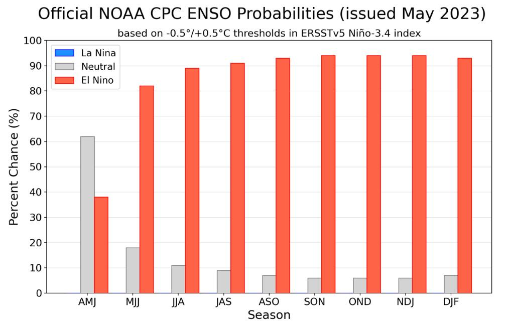
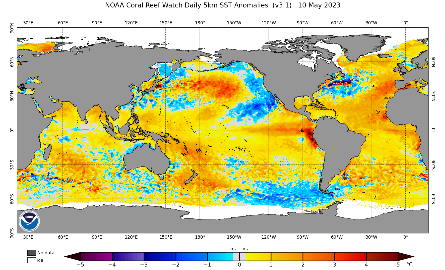
NOAA released its latest update on ENSO probabilities and they are predicting well over a 90% chance of an El Nino forming, and probably as early as June. You can see the warm water anomalies forming off of South America and starting to extend across the Pacific. El Nino is signaled when sea surface temperatures average 0.5C above normal for a three month period in an area around the equator and positioned in the center of the Pacific, a region scientists call the Niño 3.4 region.
As is the case with La Nina, the effects on the Northeast are generally not notable and will vary widely from cold to hot and dry to snowy. The region is just too far away from the primary driver to have a stronger influence. El Nino however certainly affects weather patterns and globally our warmest average temperatures are seen in such years, but a half a degree fahrenheit shift over a 3 month winter on its own is much smaller than what normal weather variability brings. It's the patterns that matter, and they typically will shift throughout the winter.
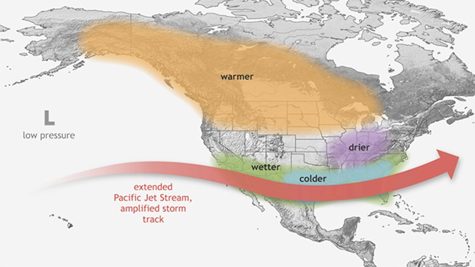
The classic El Nino pattern features some elements that are good for the Northeast such as weaker low pressure south of Alaska, riding near the Pacific coast of North America (PNA+), and a predisposition to a weaker polar vortex. These things are good for Northeast snow because they cause a more wavy Polar Jet Stream that helps to cary cold air further south and provides energy to storms, plus riding in the West (warm) is generally balanced by troughing in the East (cool). On the flipside the stronger Subtropical Jet Stream however is not necessarily good for us, especially if the jet across the Pacific is mostly straight, stronger, and further north as that will push warm air deep into the continent and cut the Northeast off from cross-polar flow which is where our coldest air comes from.
NOAA will no doubt predict warmer than average temperatures in the Northeast next winter, but this isn't El Nino at work, The warmer waters off the Northeast coast and stronger high pressure in the North Atlantic predisposes the Northeast to warmer than average winters every single year. This is pretty much a given regardless of what ENSO phase we are in. We've indicated the same about La Nina, and despite the last three winters seeing La Nina conditions, two of those seasons looked nothing at all like a typical La Nina pattern in North America, and this is also why Snowology does not characterize the Northeast winter based on what is happening at the equator in the Pacific. It moves the needle, but it won't force it and normal weather variability is can easily provide opposite patterns in the Northeast. What Snowology wants to see for predicting Northeast winter weather are the circulations in the atmosphere from 20,000' and up, and we can't see that until winter is upon us so for now it is really a flip of the coin with a bias towards warmth. For areas in the West like Alaska and British Columbia the effects of El Nino are stronger, and it is likely that they will see above average temperatures in those areas this winter. The stronger Subtropical Jet Stream is fairly likely to bring above average precipitation to the Southwest in the form of atmospheric rivers, but this isn't guaranteed. Last season La Nina should have had the opposite effect on the Southwest and they ended up having a record snow season that approached apocalyptic depths in some areas. The bottom line here is that ENSO cycles (El Nino and La Nina) are influential but not determinative.
So for those in the East, when you hear people telling you how El Nino will be affecting next winter, take it with a grain of salt. For those in the West, this is much more likely to be influential.


Comments ()