
NOAA's Climate Prediction Center (CPC) released their monthly long range updates last Thursday for temperatures and precipitation including this meteorological winter that lasts from December through February. The CPC releases these updates on the third Thursday of every month (between the 15th and 21st).
The one and three month outlooks are created by forecasters from a combination of extended range models and something known as "teleconnections" which are recurring and persistent, large-scale patterns of pressure and circulation anomalies that span vast geographical areas. For instance the El Nino-Southern Oscillation (ENSO) is one such teleconnection and El Nino conditions are a major factor in this seasonal outlook by the CPC.
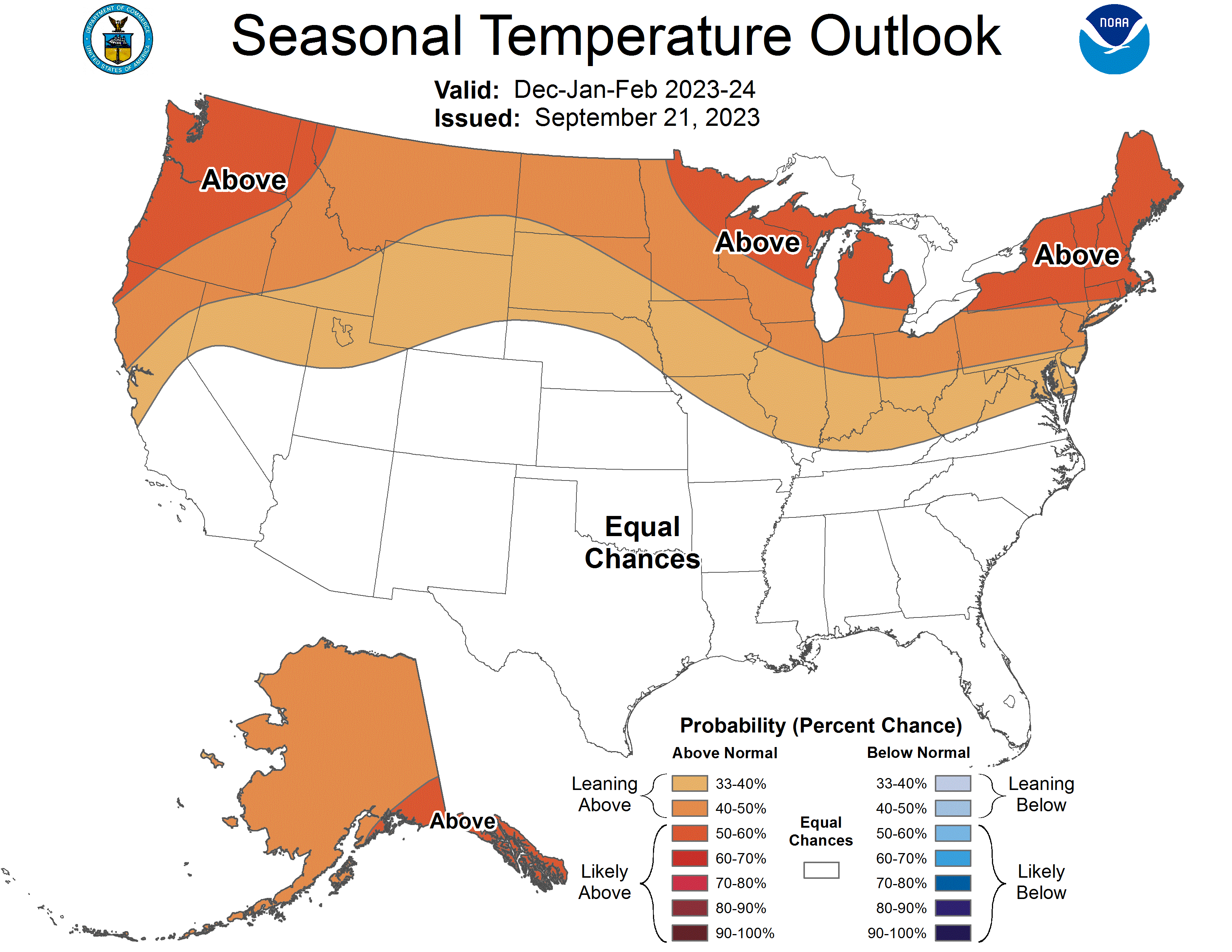
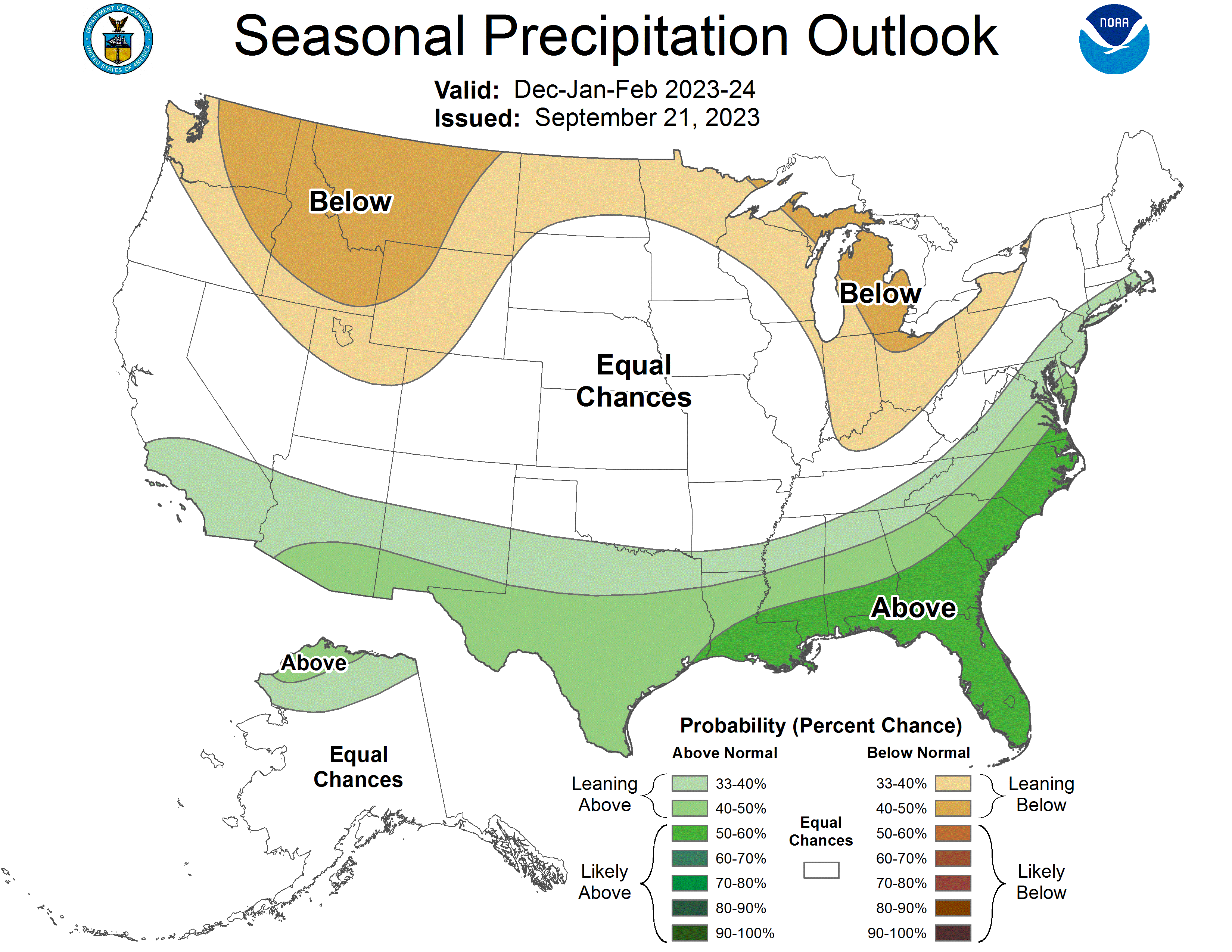
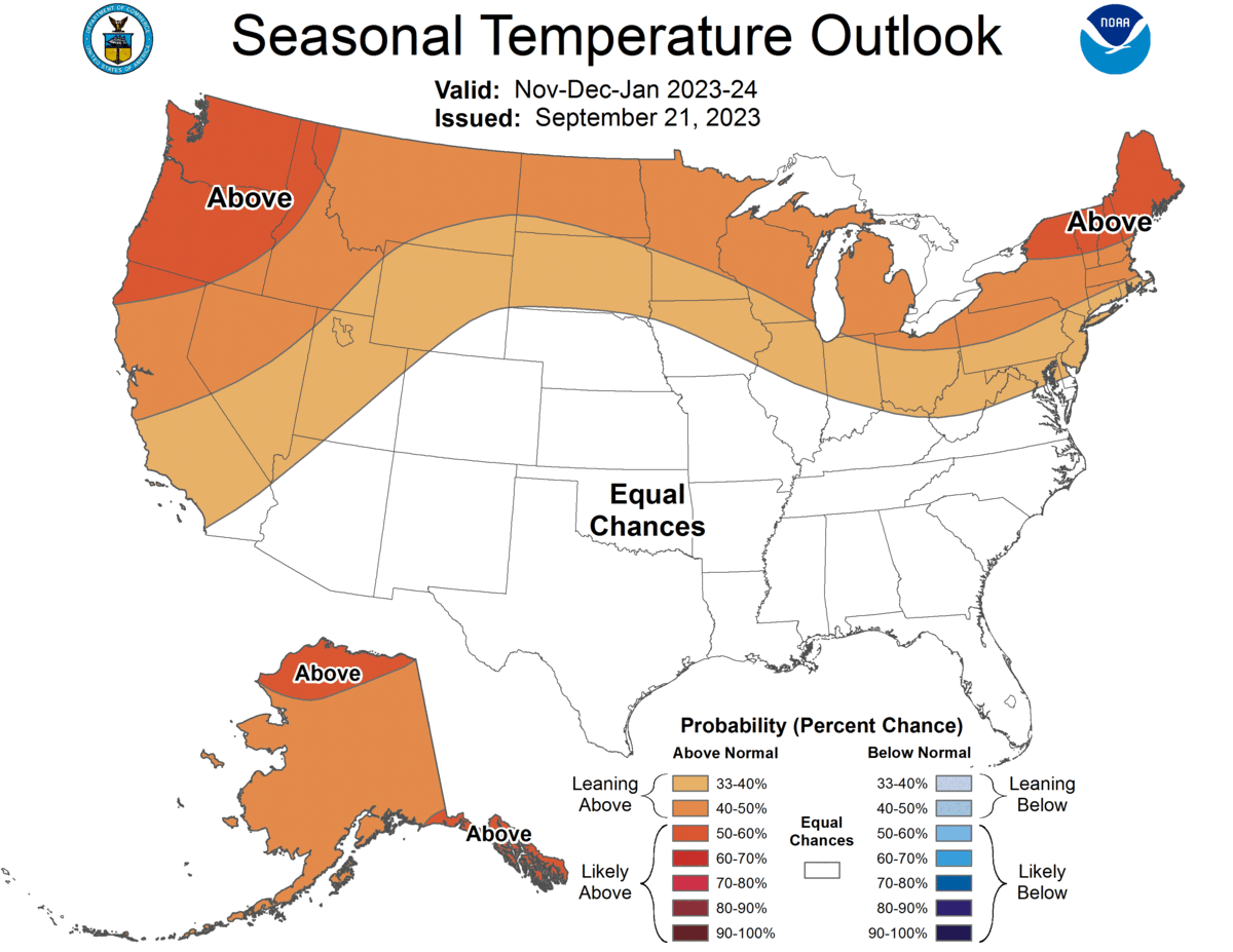
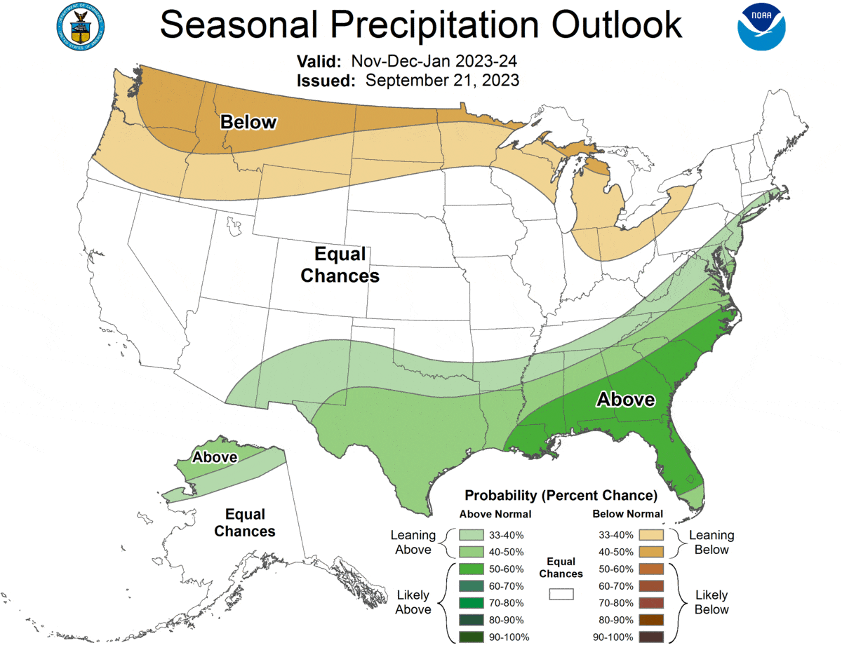
The CPC's most recent winter outlook issued on 9/21/2023.
This puts New York and New England into to the 50% to 60% probability range for warmer than average temperatures, a 33.3% chance of near average temperatures and a 6.7% to 16.7% chance of colder than average temperatures. Pennsylvania and New Jersey fall into the 40% to 50% probability range for warmer than average temperatures, a 33.3% chance of near average temperatures and a 16.7% to 26.7% chance of colder than average temperatures. Precipitation for mountainous areas of the Northeast are predicted to be generally near normal with a strong subtropical jet stream sending moisture up the Eastern Seaboard.
El Nino Is the Primary Influence
You've probably seen the following map from NOAA before which shows the generic El Nino pattern. This graphic is a bit oversimplified and doesn't fully define the primary large scale persistent patterns, but it does provide a good generic representation as to the effects on temperature and precipitation.
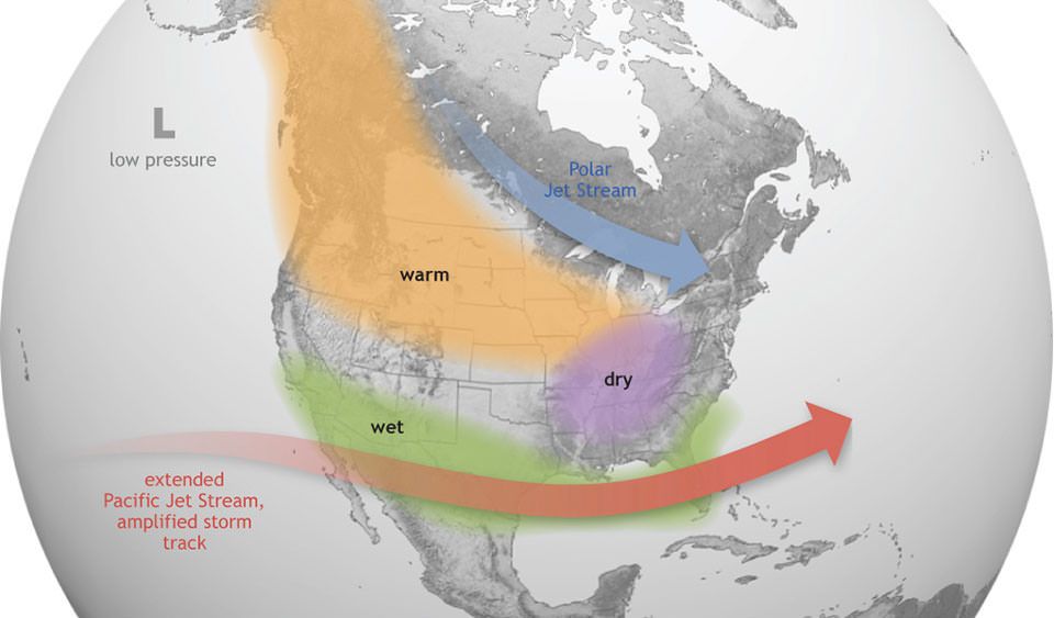
One main element of this pattern is a strong and south-shifted Pacific Jet Stream which brings more moisture to the lower latitudes of the US. That storm track does generally extend up the Atlantic Coast and this could mean more storms for places like Washington DC and Philadelphia, or even NYC and Boston. Another main element is high pressure near the Pacific Northwest causing more persistent ridging over the West and troughing over the East, which is generally a good storm track for us, however when the jet stream is split and a branch extends across the southern border it can be hard for storms to develop in the right locations for big snow in the interior of the Northeast.
Warmer to Start
While the CPC issues 3 month outlooks going out 13 months, the monthly outlooks are only provided for the next month. By animating successive 3 month periods of outlooks you can see the general progression that the CPC anticipates. Thes animations start with the Nov-Dec-Jan period and cycle through the Mar-Apr-May period.
Animations showing 3 month periods from November through May exposes how the season is expected to progress.
The CPC is generally expecting a warmer start to winter in the Northeast and then moderating somewhat. The precipitation pattern mostly stays the same until the spring. The warmer late fall and early winter are likely related to less arctic sea ice, less snow cover, and warmer open water temperatures which all help to take the sting out of cold air masses as they descend to lower latitudes at the start of the season. Over time increased sea ice and snow cover will reflect back more of the Sun's energy back into space and insulate the atmosphere from latent heat stored in the land and water.
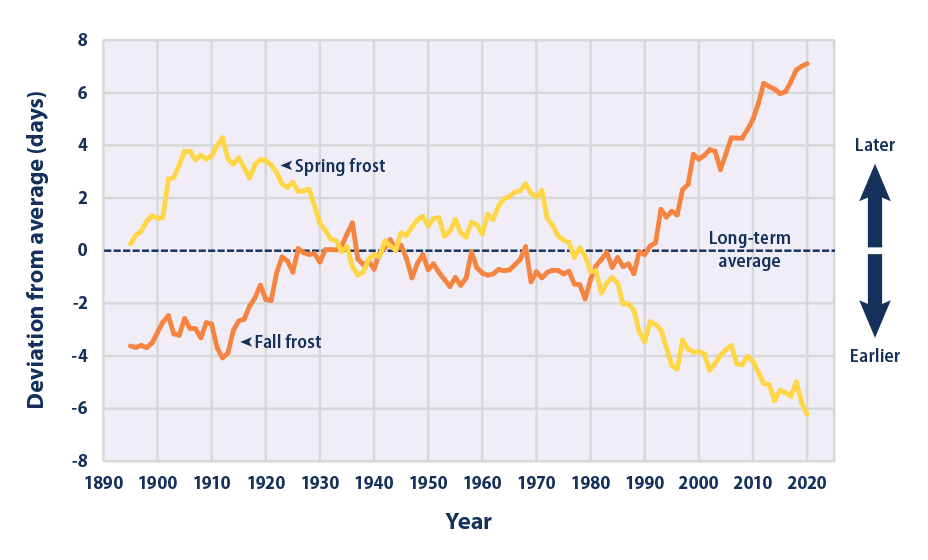
Generally speaking these winter outlooks for the Northeast will predict warmer than average temperatures and near average precipitation every winter because the Northeast has been warming faster than most other areas of the country. The trailing 3 decade averages for temperatures are unable to keep us with the rate of warming and therefore causes us to always have a warm bias in relation to the trailing averages. Generally speaking in the US we are losing about 3.4 days of winter every decade, and the rate may even be higher in the Northeast. This is shown in the long-term trends for when the first and last frosts occur.
Summary
Generally precipitation is pretty reliable in the Northeast over the full season and the quality of our winters from the perspective of winter sports enthusiasts is primarily influenced by temperatures and storm tracks. While our temperature outlook is negative, our storm track outlook is average to slightly positive. This may look bad for temperatures, but keep in mind that despite there being about a 50% chance of being warmer than normal this winter in the Northeast, that means there is about a 50% chance of being near average to colder than average in temperatures. El Nino also favors a weaker Polar Vortex which means a wavier Polar Jet Stream with more potential energy for storms, and in the Northeast a weak Polar Vortex is by far the pattern we wish to see the most, so that's a positive. This outlook for Northeast mountain winter sports is actually somewhat neutral when you consider the weather pattern that is associated with their forecasts.
There's plenty more to discuss regarding the winter outlook and we'll follow up with our own deep-dive into El Nino and related patterns in the near future.


Comments ()