
Everyone wants to know how the next winter is looking. The long and the short of it is that unfortunately no one can accurately predict what the next winter will bring with any regularity, there are just simply many variables at play. The best we can do is estimate the probabilities of basics like temperature and precipitation anomalies based on large scale oscillating patterns.
In the Northeast there probably isn't a single large scale pattern that would lead NOAA to predict an average to cooler than average winter for our region. Our averages are based on the trailing 3 decades of data, and we've been warming so quickly that the averages are always behind the current climate. Warm water off the coast has become a fixture of our climate, and while this helps create more explosive coastal storms, it also adds warmth that changes what might have been snow for some areas 50 years ago to r--n, and otherwise helps melt the snow faster that fell or is made. The arctic ice extents have been trending lower and lower by decade, and that means more open water adding warmth to the cold air on its way towards us earlier in the season. That warmer than average water is also normally a fixture in the Great Lakes which take the sting out of the cold blasts coming down from Canada in the Fall.
So warmer than average is the default prediction for the foreseeable future, but how much warmer than average does matter, and what sort of weather patterns are associated.
El Nino Is the Elephant in the Room
We are already in an El Nino with sea surface temperatures in the associated region already rising 0.8C above average, however this won't be officially declared until these anomalies are found in 5 subsequent 3 month periods, which is practically a formality at this point. ENSO extremes (El Nino and La Nina) have clear influence on large scale weather patterns. These influences are stronger in the west than in the east due to proximity and exposure to other large scale patterns, and the stronger the El Nino or La Nina, the more influential these patterns can be. We seem to be on our way to a Strong El Nino or possibly another Super El Nino like we saw in 1982/83, 1997/98, and 2015/16.
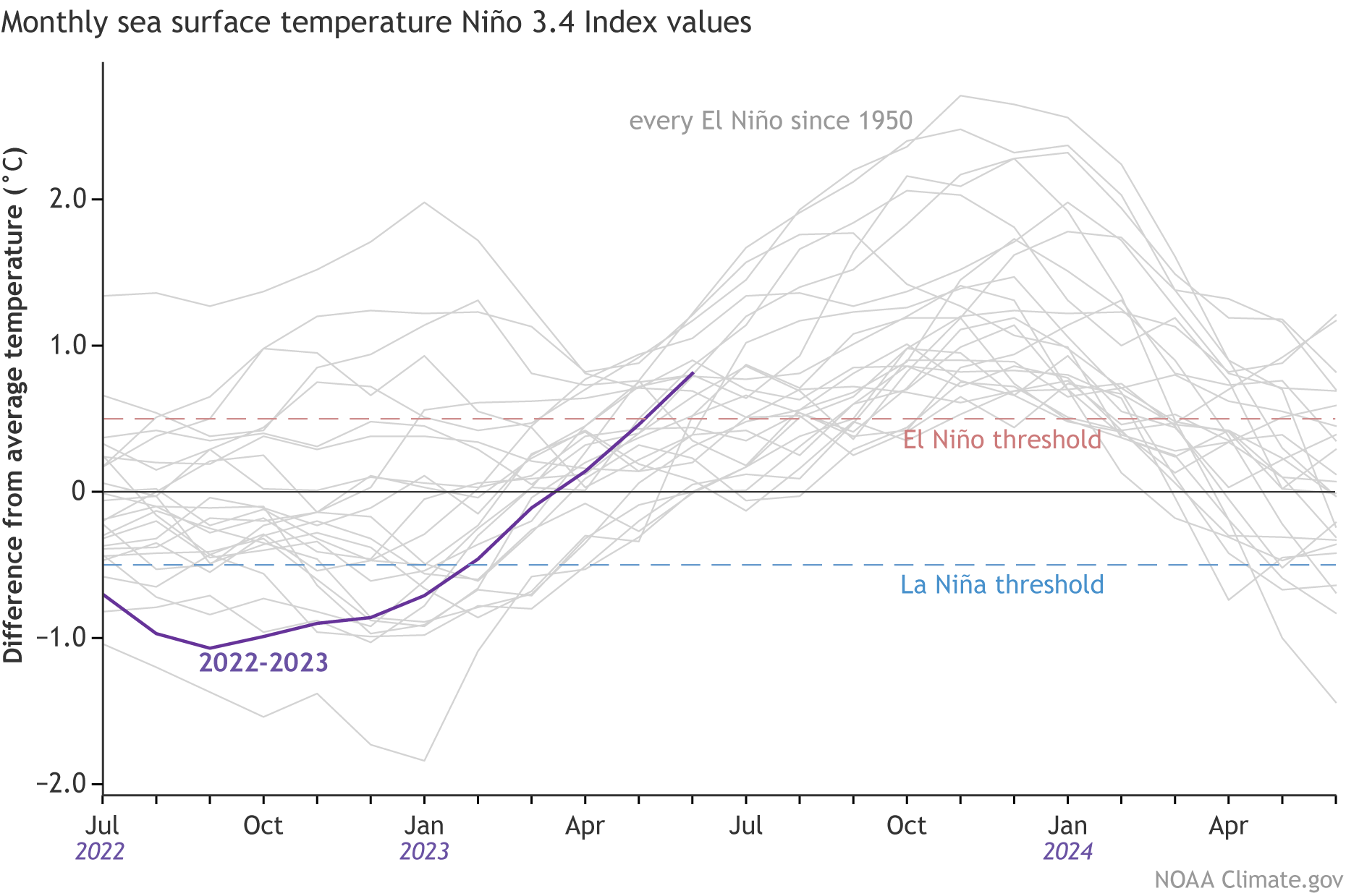
NOAA issued their latest El Nino outlook last week in their monthly ENSO Blog. Models are presently showing an 80% chance that this El Nino will peak with a maximum index of at least +1.0C (Moderate El Nino), a 50% chance of at least +1.5C (Strong El Nino), and a 20% chance of above +2.0C (Very Strong El Nino, aka Super El Nino).
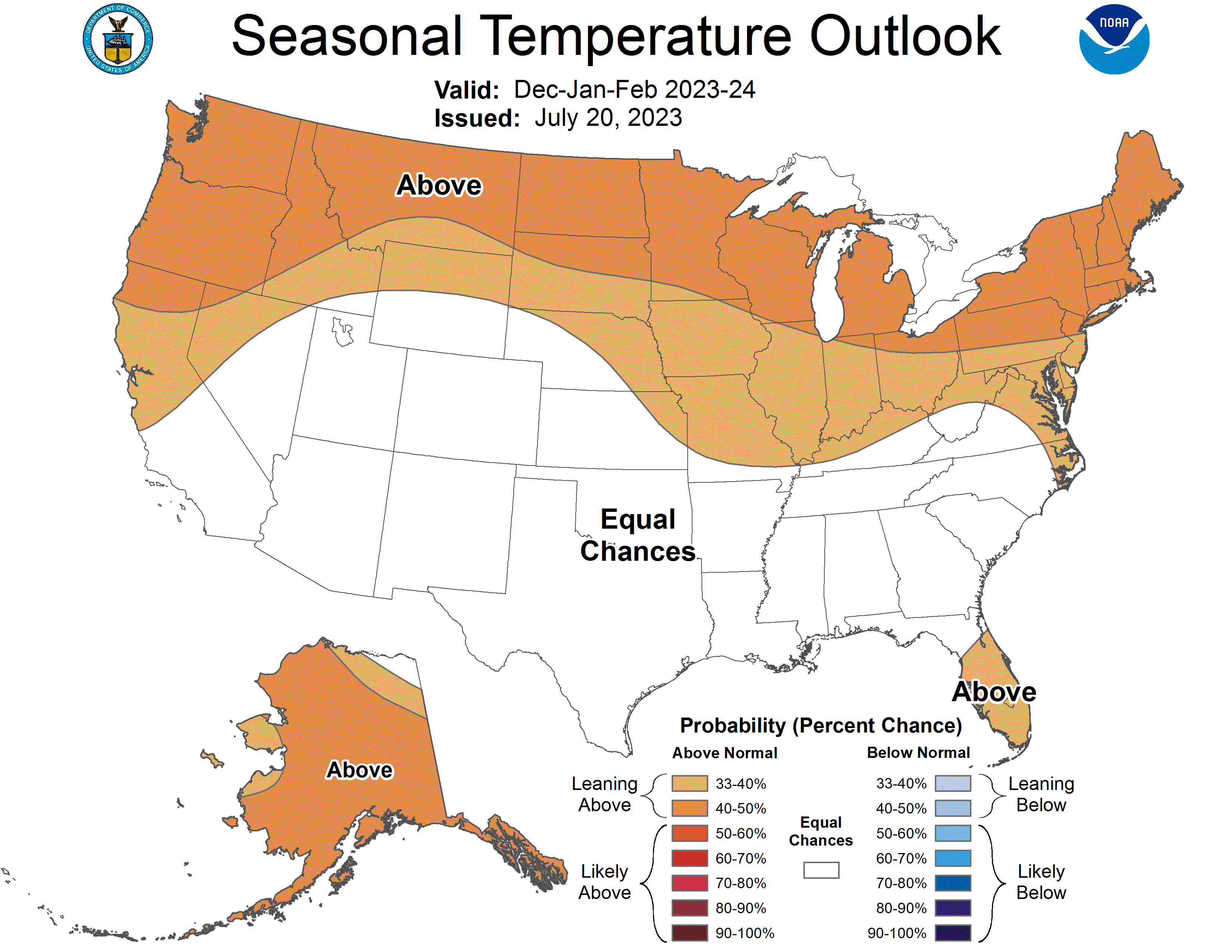
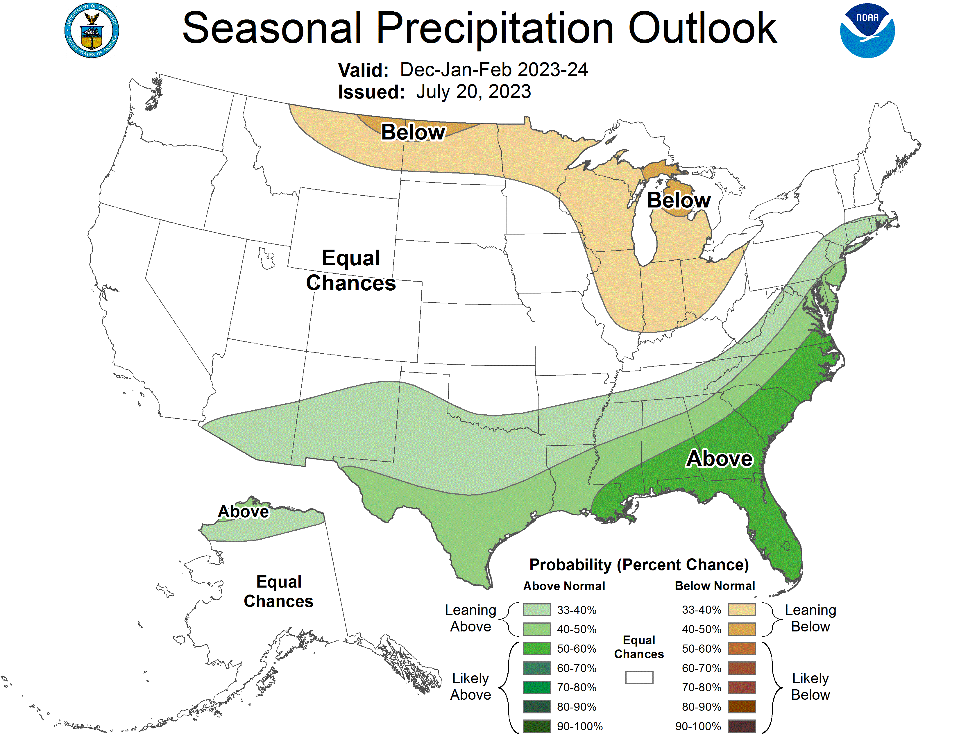
NOAA's Climate Prediction Center issues outlooks up to 12 months in advance, and they tend to rely on these large scale weather patterns and analogs built from the average across many years with similar influences. It's not a surprise that they are predicting temperatures and precipitation next winter that reflect the standard El Nino pattern, and their outlook is unlikely to change much as we get closer. That doesn't of course mean these will confirm, in fact they are only predicting approximately a 50% chance of above average temperatures in the Northeast and that is the responsible way to express the certainty of this pattern in various parts of the country.
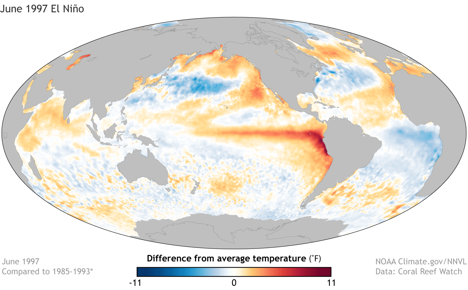
Could a Super El Nino Ruin Winter in the Northeast?
There's probably no stronger analog than a Super El Nino where temperatures in the Nino-3.4 zone of the Pacific reach a 3 month average of +2.0C. We've only recorded 3 of these events precisely, 1982/83, 1997/98, and 2015/16. If any of those winters stand out to you, that would not be a surprise; they were memorably awful in the Northeast. The stronger the ENSO extreme, the stronger the influence is on our weather. The following two graphics show the departure from the 1981-2010 averages for the 3 Super El Nino events. A Super El Nino seems to have a high probability of a very warm winter for the Northeast due to the effects on jet streams and weather patterns, but with only 3 of these events recorded there is a possibility that the effect is overstated.
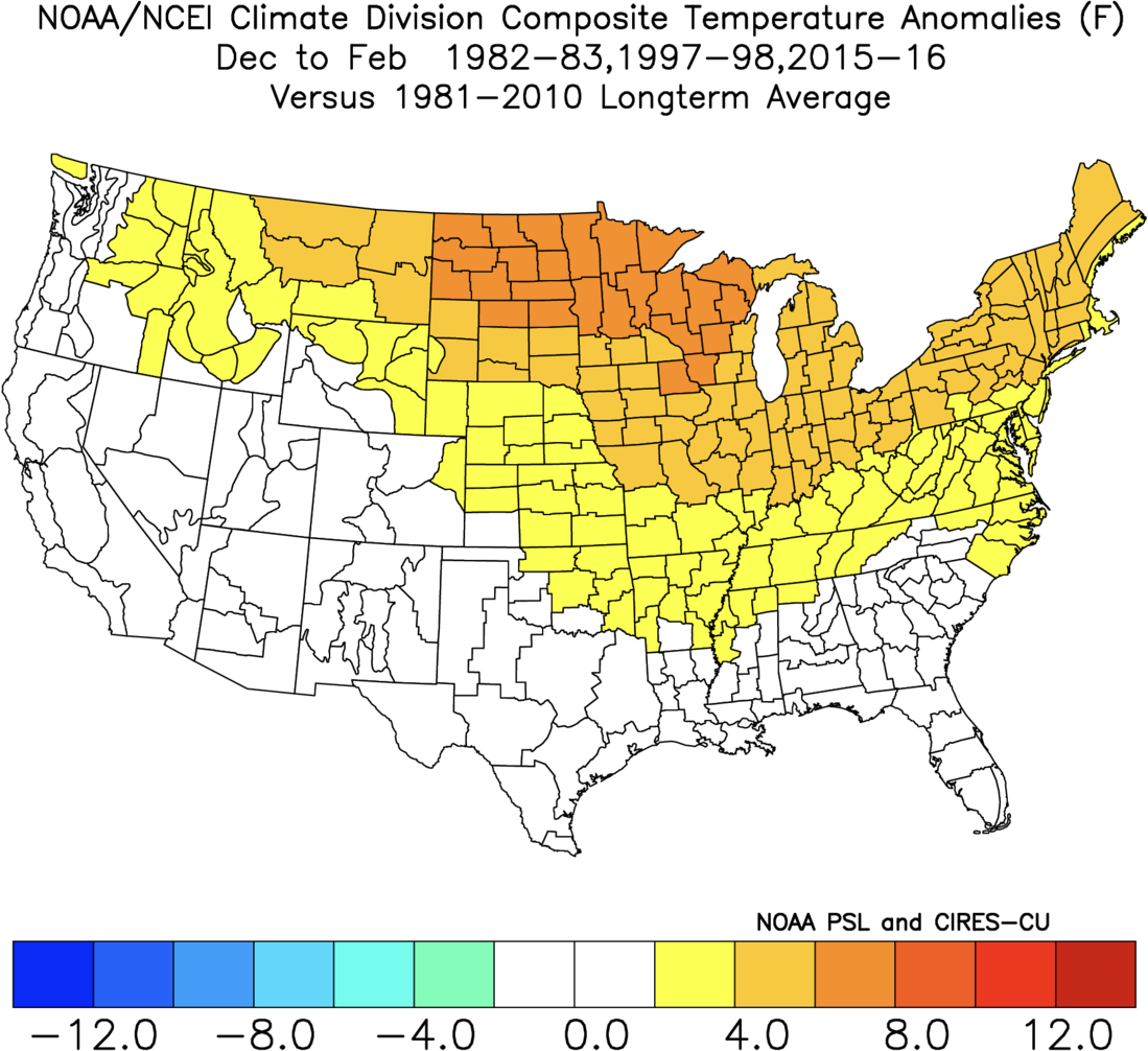
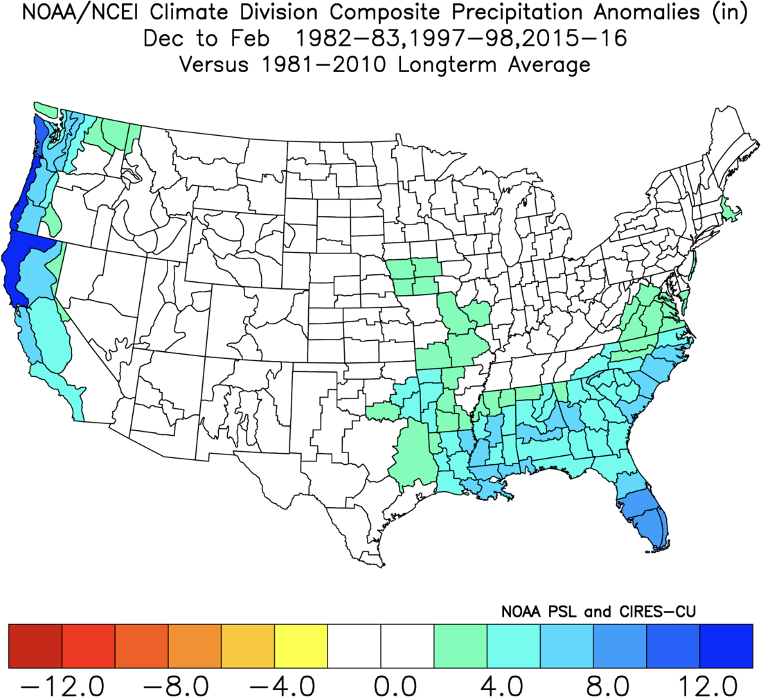
NOAA only puts the chances of a Super El Nino at 20% at this time, but the models are worrying and it is unlikely that we would see stronger signals than we are seeing right now for what is to come this winter. Curiously, if you look at the analogs from the Strong El Nino years where temperatures range from +1.5C to +2.0C, there is only a weak influence due to far more variability, but the sample size is just 5 winters for this so that is also very suspect.
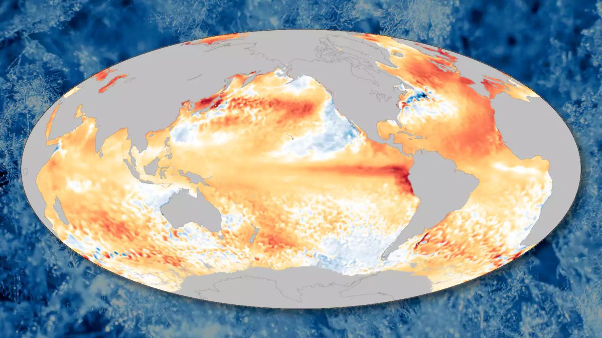
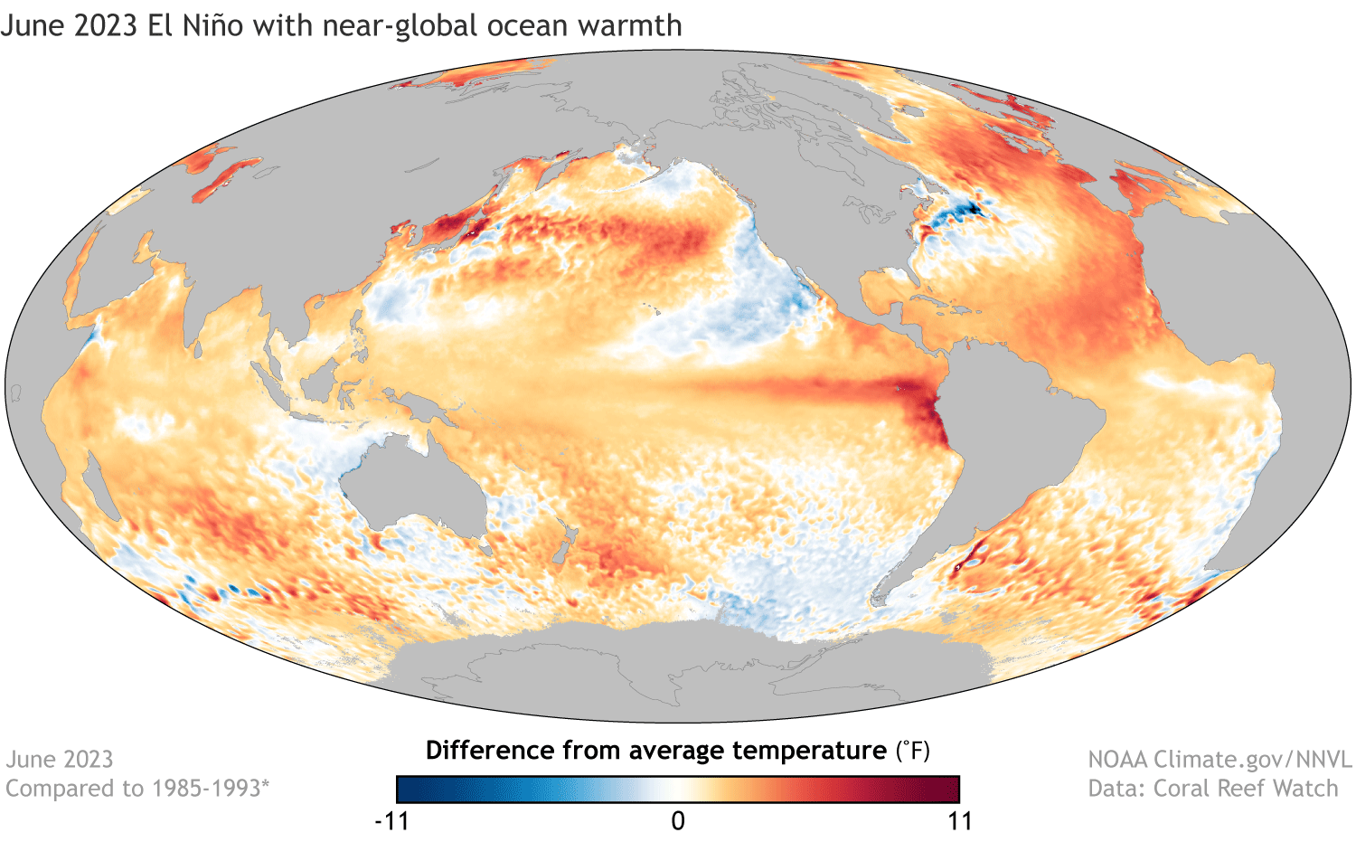
With ocean temperatures all over the globe reaching records, and in many cases smashing through older limits while sea ice is experiencing record lows in many parts, some meteorologists are expressing alarm about a possible Super El Nino with global effects. This is in fact scary to see.
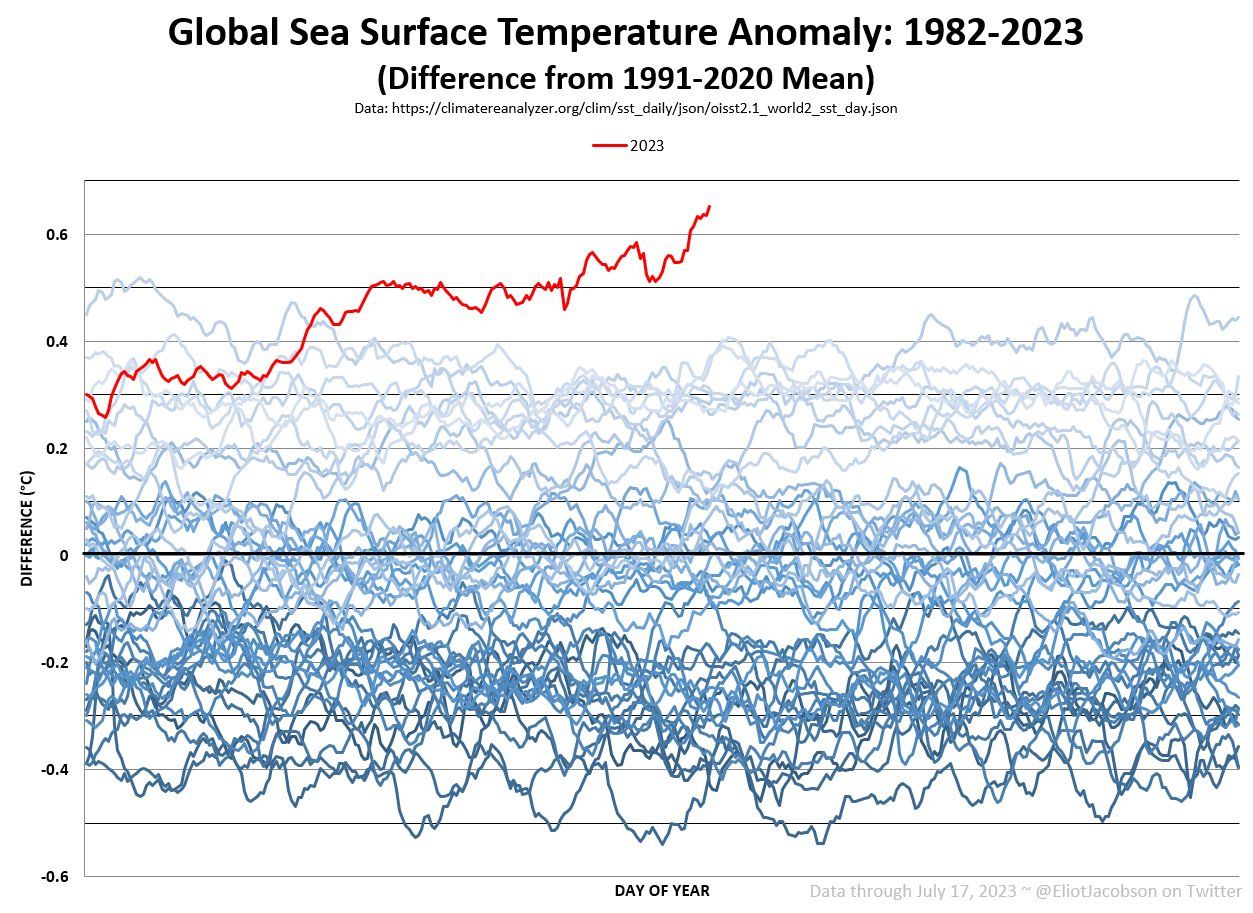
There are however some good arguments against this resulting in a terribly warm pattern for the Northeast next winter. As indicated above, we only have 3 analogs for a Super El Nino and that sample is too small for high confidence. It's reasonable to assume a warming influence on the Northeast, but how warm that influence might be is still an open question. The other argument has to do with how warm the water is in the Nino-3.4 region in comparison to the rest of the globe. If everything warmed by 2.0C, would that cause a change in weather patterns? NOAA explored this very question in the latest ENSO Blog. With the oceans warming to an extreme all over the globe creating less relative temperature differences, maybe what we would consider to be a Super El Nino due to temperatures in the Nino-3.4 region has much less influence over weather patterns when we are seeing warmer than average sea surface temperatures all over? They provided examples of the 1997 Super El Nino and the current sea surface temperatures to demonstrate how this El Nino may in fact be different from past strong events and the influence on weather patterns possibly being more "muddled".
Snowology's Outlook
We don't pretend around here to be able to accurately predict the weather 6 months out. There are just way too many variables present every winter, in fact none of the past three La Nina seasons were good matches for analogs and we saw record amounts of snow in California, Nevada, and Utah last season despite the pattern suggesting average to below average snow in those areas. Next winter there is some obvious concern however that can't be ignored. Things are very hot and it is likely that at least a Strong El Nino will develop, and temperatures in the Northeast are even more likely to be above average yet again while the entire planet seems destined to record its warmest year on record.
In the Northeast though it is a given that we will have periods of boom and bust when it comes to snowfall and temperatures. That's just how we roll. The patterns from week to week depend on where troughs and ridges set up and how persistent those patterns are. Last winter we first experienced a strong Polar Vortex and strong Pacific Jet Stream which are the kiss of death for our winters because they work together to keep cold air locked up further north and reduce the chances of big East Coast storms. This pattern broke down by February as warm air was repeatedly pushed far north and the Polar Vortex was shifted towards Europe causing a series of sudden stratospheric warming events that severely weakened it, and then we finally received some big storms to rescue the season. That's a great example of a very strong influence that can't be predicted with much accuracy until at most a month out. Chances are that part of the coming season will suck, and part of the season will be great, and the open question is merely how much of each are we likely to get and when. Our best winters overall tend to result from early and late cold and snow, so the timing of the variable patterns also matters a lot, and there is no way to predict what patterns will exist at any given time at this distance. We watch this from weeks out, not months out, and that is how we will cover the weather here.
The bottom line is that you, not the weather, determine your degree of enjoyment, so make the most out of whatever Mother Nature delivers. If the weather is extra challenging and getting you down, consider changing up your normal plans to hunt the better conditions where they exist at that time. While most of Snowology's followers primarily ski or ride the same mountains most weeks, those who use our coverage to find the snow and better conditions are often the most satisfied. If you don't like ice, then go another hour or two further or in a different direction in order to find the pow. Most of you have multi-passes, so use them! Even if conditions aren't better elsewhere, exploring new areas can create very memorable experiences.


Comments ()