Hey everyone, Snowology is back for the season and that means we've got some wintery-ish weather to start talking about as the countdown to snowmaking and opening days in the East starts in earnest. For non-subscribers our early season coverage will remain un-paywalled until it becomes actionable.
Some Cold Air Is Incoming
Let's get right down into the short-range outlook. While it will be chilly for an extended period and some accumulating mountain snow could be on the horizon, I don't expect productive snowmaking to start until sometime in November. Here are the NWS forecasted temperatures for both Killington's North Peak and Sunday River's Locke Peak over the next 7 days.
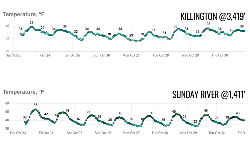
Simply put, there isn't a productive snowmaking window here and any snow that is made will likely melt before another window hits, so we expect everyone to sit this out except for training and marketing reasons, or at least they should in my opinion. Note that Sunday River will run up to about 2F colder than shown at the top of Locke because the sample point is a little low in elevation than their opening terrain.
Snowmaking generally starts somewhere between a wet bulb temperature of 30F to 28F at these early openers. If you aren't familiar with what a wet bulb temperature is, it measures evaporative cooling and the more humid it is the less evaporative cooling there will be. At 100% relative humidity the wet bulb temperature equals the air temperature because saturated air doesn't support evaporation, but for every 10% drop in relative humidity you see approximately a 1F reduction in the wet bulb temp. Early in the season the relative humidity often rises sharply at night since colder air has less capacity for water vapor so a a rule of thumb we can expect wet bulb temperatures to be about 1F-2F below the actual air temp at night during this time of the season. The long and the short of this is that they're looking for a minimum of 6 hours of air temps of 30F and below and for there to be enough of that on the horizon to string together at least 3 days before snowmakers go for broke, or at least that's the most responsible and efficient approach...
So When Will Snowmaking Happen?
While weather models are currently playing with a big coastal storm around Halloween and the internet weather hypesters are already pushing that possibility, it's likely a fantasy storm due to both range and the chaotic nature of our jet streams right now. Here's a loop showing the jet streams (expressed as upper level wind speeds) from Monday through the next 10 days.
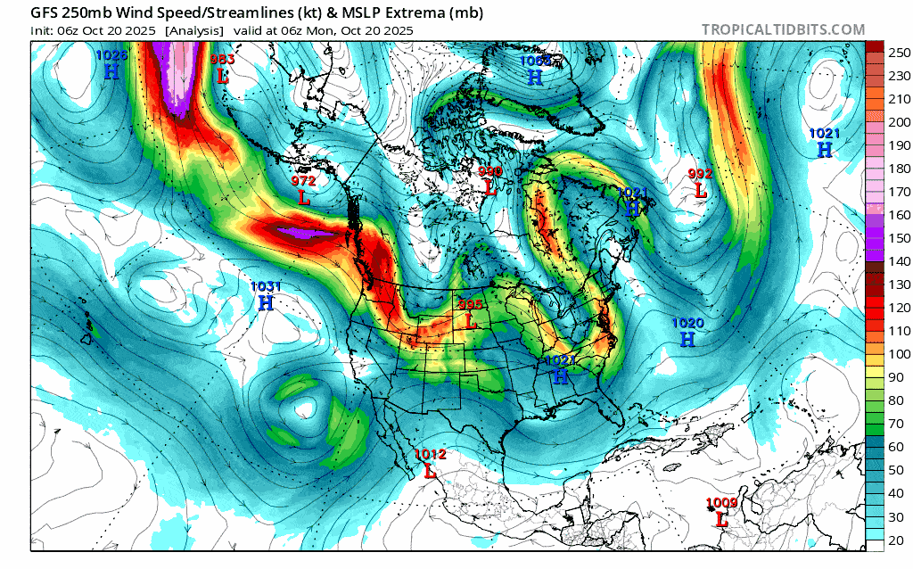
To me this looks like chaos, and there's a reason for that. Something known as a "Pacific Jet Streak" has formed across the Pacific and that's a kiss of death for lasting cold hits in the East. Here's another view of the jet streak as it looks today.
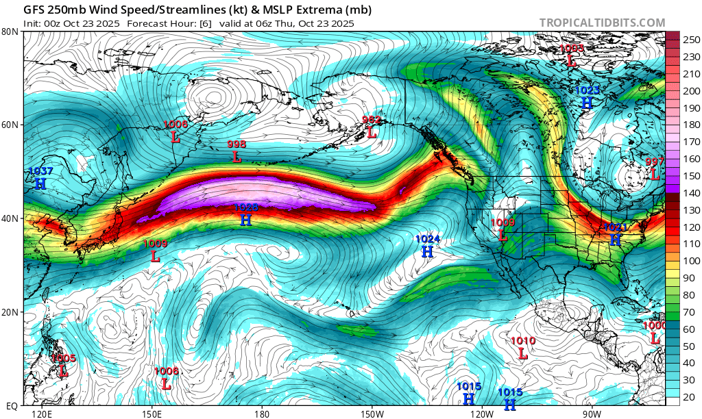
That purple area of very high winds up around 35,000' up in the atmosphere a combination of the polar and subtropical jet streams. This isn't necessarily uncommon to see for stretches of time during the winter though this is early for it to appear. When the jet streak hits North America after a 7,000 mile trip across the generally calm and flat Pacific Ocean, it crashes and folds, creates chaos in upper level flows, and pushes warm air deep into the continent while cutting off Arctic flow. Our cold air in the East almost always comes down from the Arctic across Northwestern Canada and given that it's only October and we need extra cold air to make snow. This isn't at all good to see if you are a skier or rider.
Now let's switch to the 500mb level pressures (about 18,000' up) with a view of the Northern Hemisphere with North America at the bottom of the map. This level is where the main steering flows are in the atmosphere. When we talk about upper level lows, ridges, and troughs, it's this level of the atmosphere that defines them.
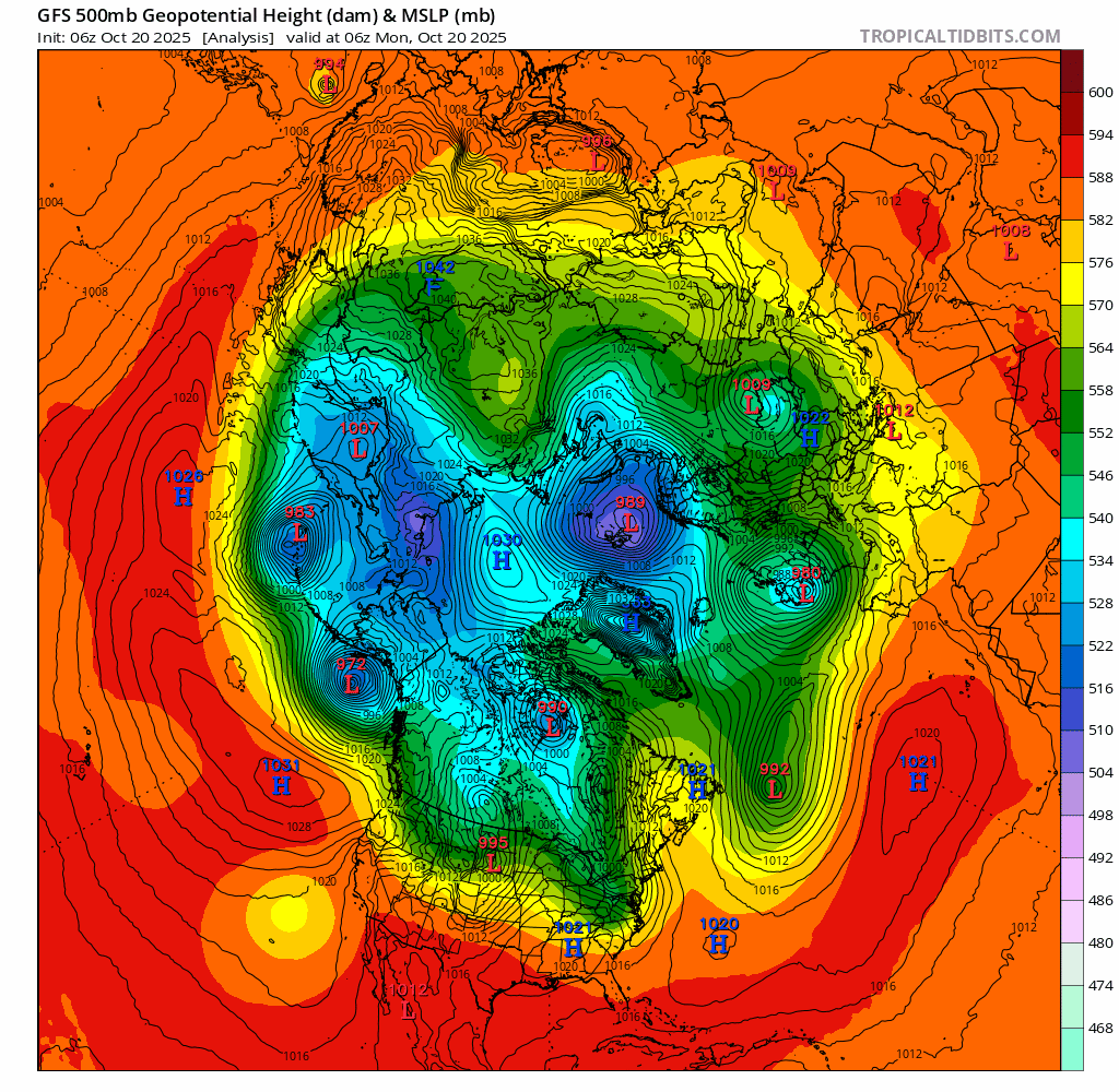
What you are looking for here is the 540mb pressures starting in the blue shades (I'm simplifying for readability if you know better) which generally indicates where snow supporting weather is near sea level. It also indicates generally where snowmaking temperatures might be seen.
What I would like for you to notice from this loop is how the lowest pressures are isolated mainly to the Western Arctic areas, with only brief incursions of lower pressures reaching the Northeast. What is happening here is the screaming Pacific Jet Stream is cutting off that Arctic flow from reaching us.
Some less experienced forecasters will spend most of their time looking at temperature and precipitation maps run to run while trying to call cold hits and storms 10 days out. The proper way to start looking into the extended range is to watch upper level flows because they set up the environment, they give an indication of how reliable the modeling is while surface modeling is less reliable at a distance. At this moment the ECMWF and GFS both see a potential coastal storm sometime around Halloween, and the GFS sees it captured by a large upper level low that brings a round of snow and some deeper cold but I would give that scenario a pretty low chance of happening because jet stream chaos of this variety hurts extended range accuracy, the setup is tentative (easy to break with shifts), and the GFS solution seems overblown (errors in modeling tend to multiply and grow with time).
The Bottom Line
We only need about 3 decent days of snowmaking for Killington and Sunday River to open for the season and that's not out of the question in the next 10 days, but right now I'm afraid that I would strongly bet against it.
While we might see a decent 3 day cold hit capable of starting the season as early as the beginning of November, generally I would expect a slow start to the snowmaking season in the East. Sorry, we don't sell false hope at Snowology.
A screaming Pacific Jet is in fact associated with La Nina, though we made it through the last La Nina season without hardly any of this happening. Stronger low pressure south of Alaska, which is also associated with La Nina, helps concentrate the jets in this manner. We need a ridge to form over the Northeastern Pacific in order to break this up but I've seen this pattern last for over a month at times and it's practically impossible to predict when that might happen until it starts to appear in the modeling, and as yet that has not happened.
Knowledge Is Powder!
-- Matthew Scott


Comments ()