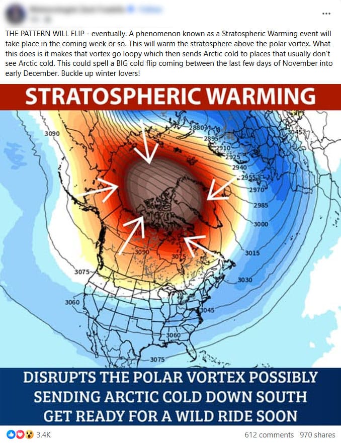
If you see viral weather coverage on social media and even TV at times, you may have heard that there will be a Sudden Stratospheric Warming (SSW) event and we're all going to freeze to death or something like that. I'm going to try to cut through the hype while also trying to explain what this is all about without a lot of jargon so that you can understand better what to expect...if anything.
<RANT>
Please allow me to vent a little bit though as I'm all worked up due to severe weather hype, 45 day snowfall maps, and people generally making everything as extreme and alarming as possible on the internets in order to get clicks. That's literally the new normal and I'm afraid this is here to stay. The coverage you are seeing on this Sudden Stratospheric Warming is generally more likely mostly wrong/overstated or baited with scary graphics and careful wording doesn't matter in the full context. This is likely often not purposeful but rather due to a combination of a lack of understanding of the effects and undue focus on how to get attention. It's like performing rather than informing these days. I'm afraid this works really, really well for getting engagement and it is becoming especially bad since platforms like Facebook not only monetize content creators, they also reward engagement bait by boosting posts to millions at times making this the way you must play the game if engagement is the primary goal. The most popular social media weather coverage that you come across is generally garbage now as a result and it is actually harmful to the public trust when people do things like push cherry-picked fantasy storms and effects 15 days out that don't end up occuring and you end up exhausting people by constantly pulling on their emotions, even causing fear and anxiety in some. It's irresponsible in my opinion even if it is somehow correct-ish when you take into account all of the caveats since few actually do.
</RANT>
On the positive side if you search hard enough you will find a lot of responsible meteorologists, scientists, and forecasters addressing the hype and presenting well-founded guidance, but those posts don't go viral, nor will the one linking to this article. I'm afraid to say that the cards are stacked against reasonable and responsible content on most social media platforms these days by the platforms themselves. In a perfect world the National Weather Service would be the gold standard for general and severe weather guidance instead of some dude with a YouTube channel, a knack for creating alarming thumbnails, and wrapped SUV with its name printed on the side. It's on you to navigate through this and figure out who you can trust, and that unfortunately applies to everything these days.
So let's get down to business now that I got this off my chest.
What Is the Stratosphere and the Polar Vortex?
First off, we live in the Troposphere and that is where weather happens because about 99% of the water vapor in the atmosphere is in this bottommost layer, and also about 80% of the atmosphere's total mass. At Northeast US latitudes the Troposphere is about 36,000' thick though it varies by temperature and pressure and likewise is shallower at the poles and thicker at the equator.
Above the Troposphere is the Stratosphere and while it is much thicker than the Troposphere, rising to around 150,000', it contains only about 1/4 of the atmospheric mass. Beyond that there are the Mesosphere, Thermosphere, and Exosphere but these have no measurable effect on weather and only contain about 1% of atmospheric mass collectively, but this is where things like meteors tend to burn up and where the aurora borealis occurs.

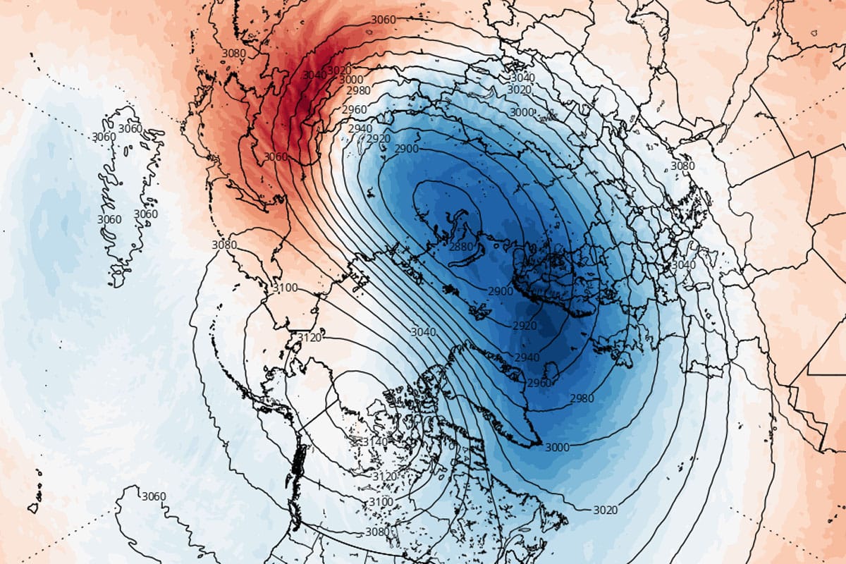
The Polar Vortex is a wintertime phenomena over both poles and it basically describes a reversal of the wind direction in the Stratosphere. During the warm months the wind in the Stratosphere actually flows opposite the prevailing winds in the Troposphere, but they reverse and blow west to east during the colder months due to increased temperature gradients between the equator and the pole and when this happens we call it the Polar Vortex.
While the Polar Vortex doesn't produce weather per se, if the circulation is strong and persistent it can have an effect on the Troposphere through a process called "coupling" which hopefully is self-explanatory, but if it is weak it has very little effect on the cold in the Troposphere though it can influence the Jet Stream when it is shifted from the pole. The following graphic from NOAA explains this better than words for a basic understanding.
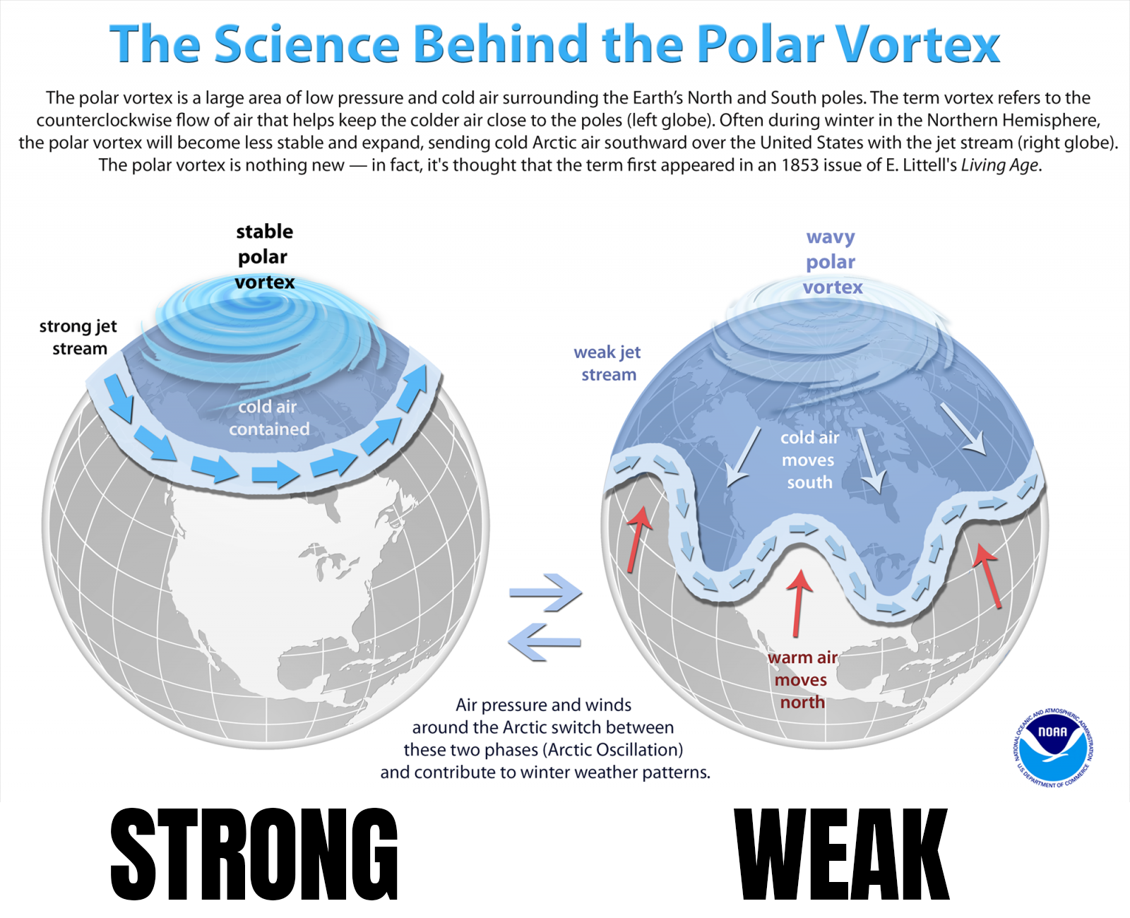
I've said this many times through the years; a persistently strong Polar Vortex can be the kiss of death for Northeast winter weather as that contributes to a very strong jet stream developing across the Pacific that mixes warmer air from the Pacific deep into North America and works to cut off cross polar flow which is where our coldest air comes from. It may sound counterintuitive at first, but a weak Polar Vortex and less cold in the polar regions creates more cold and storms at lower latitudes. While a strong Polar Vortex can be beneficial for snow in some other regions, it definitely is not in the Northeast. Note that a strong Pacific Jet Stream can also occur without a strong Polar Vortex, it's simply more likely to happen when it is strong.
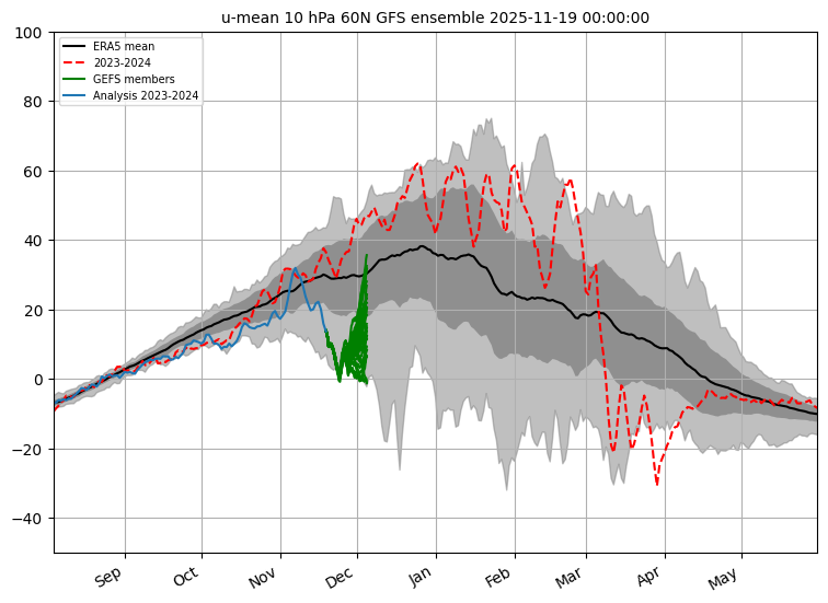
So how do we determine if the Polar Vortex is strong or weak you might wonder? We measure the average wind speed at about 90,000' up in the Stratosphere (the 10 hPA level) at 60° latitude which is about 400 miles south of the Arctic Circle. This is generally where the strongest winds associated with the Polar Vortex are. This is only an approximation though as the PV can be somewhat strong yet shifted, but it's the best approximation there is. Here's a chart showing how fast these winds average by date (black) as well as where we are now (blue), where the GFS ensembles say it will be in the coming weeks (green, multiple lines and a wide spread), plus last season's results (red).
What Is a Sudden Stratospheric Warming Event (SSW)?
In the simplest terms Sudden Stratospheric Warming (SSW) describes an event where warmer air from the Troposphere breaks through to the Stratosphere causing a weakening of the Polar Vortex and warming of the Stratosphere which will often also move its circulation off the pole, make it more oval, or even split it into two parts.
Not all warming events count as a SSW, in fact this paper sets out many different standards in an attempt to define exactly what counts, and that is generally when wind speeds reverse or dip below zero on the chart above, meaning the average winds during colder months are flowing east to west for a period instead of west to east. Note that while last year there were very regular warmings and dips in the strength of the Polar Vortex, I believe only the March event technically qualified as an SSW, and this was the earliest we had seen the Polar Vortex dissipate as it never recovered. Nevertheless those frequent events kept the Polar Vortex from coupling with the Troposphere despite it being pretty strong on average, and therefore it had no notable negative effect on our weather last winter.
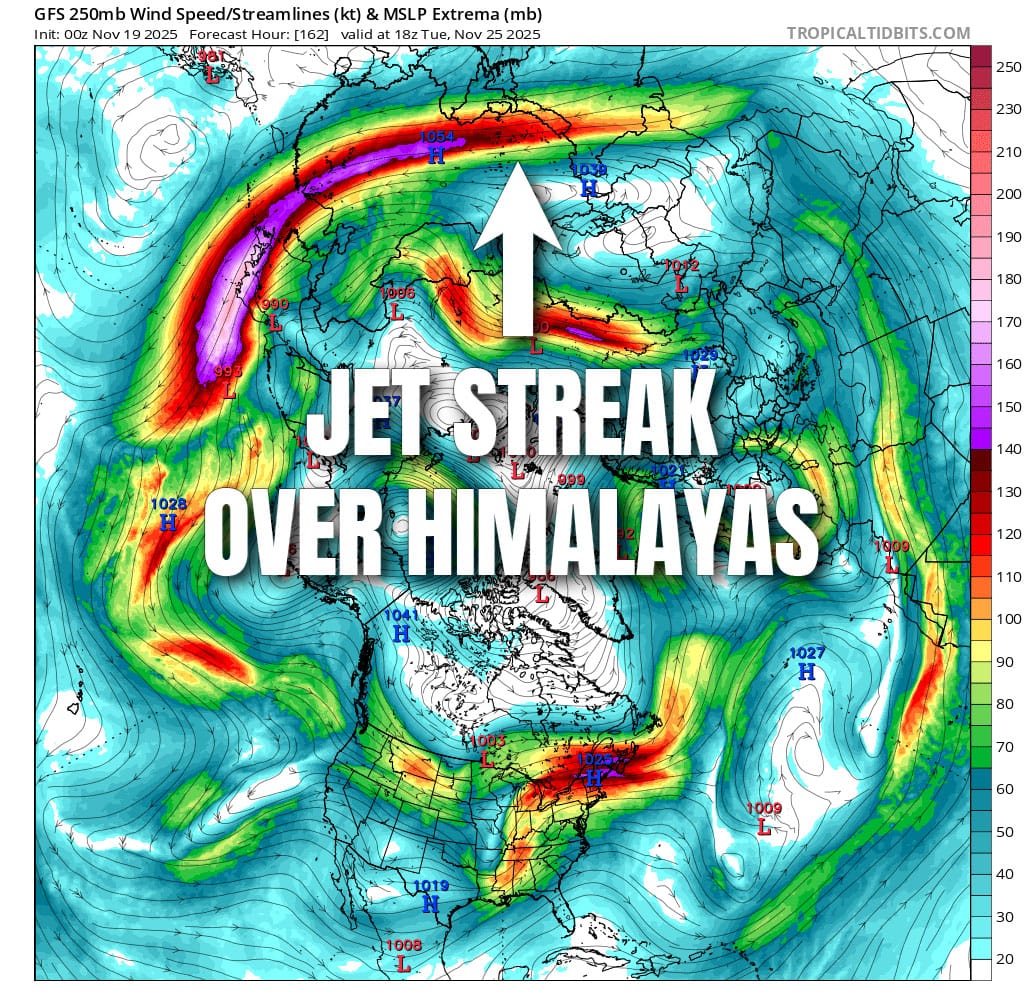
The causes of these SSWs vary, but they are typically the result of strong storms moving high into the Arctic generally from the Bering Sea or the North Atlantic, strong and persistent high latitude ridges of high pressure like a Greenland High (NAO-), and also strong jet streaks passing over the Himalayas (Asian Mountain Torque) as those mountains practically touch the Stratosphere. It also helps a lot when the Polar Vortex is already displaced and stretched into lower latitudes as it is now, making it easier for tropospheric events to reach it more directly. This particular SSW event is likely the result of a jet streak over the Himalayas while the Polar Vortex is displaced into Europe and Asia.
Why Is This SSW Likely Not a Notable Influence on Our Weather?
It's simple. The Polar Vortex is generally weak early and late in the season and it's already anomalously weak for this time of year before the SSW starts. It is also already oblong and shifted, and it will not look a whole lot different after the event is over. Yes, the Stratosphere will warm, but that doesn't affect our weather and it wasn't coupled with the Troposphere and therefore isn't going to leak cold into lower latitudes because it is already there. Since the Polar Vortex is not modeled to move much or split, it probably won't affect the jet stream much differently than it already is. One could even claim that the Polar Vortex after this event will have less effect on our near-term weather patterns than before; the exact opposite of what some are claiming.

Now if it was strong to start, this would be a very welcome sight for snow and cold lovers because it could help release cold air from de-coupling with the Troposphere and shift the Jet Stream with deeper dips and higher amplitude waves, though the effects are not always felt in the US much less the Northeast. This is what those who hype are getting wrong, not all SSWs are notably impactful and they are assuming it is without looking deeper. It's an over-simplified generic take. This SSW event looks pretty much to maintain the status quo and be no more than a weather curiosity. We may see some cold intrusions into the US following this event, but that will be due to primarily what is happening in the Troposphere rather than changes in the Stratosphere. It is good though to see the Polar Vortex not continue to get stronger, so that is a short term positive if you like cold and snow in the US, but not a determinative influence as there are other patterns that also matter of course.
This event coming up may in fact be exceptional in one regard however. According to Dr. Amy Butler, one of the authors of that paper classifying SSWs, this event could be the earliest ever recorded if it confirms, but it's early in the season and it will recover. Much of what I learned about these events is from people like Dr. Butler, and I follow her on BlueSky and you should too if this sort of thing interests you at that level.
-- Matthew Scott
Knowledge Is Powder!
Comments ()