We're just dialing in the snow, the wind, and the temperatures now and extrapolating that into a solid expectation of what to expect this weekend from this fairly productive clipper that the Snowology Powculator is currently seeing 54 tracked Northeast ski areas as receiving between 4" and 14.4" of snow by Sunday morning.
Here's the latest broad view from the GFS covering Friday through Monday.
I'm going to update the Snowfall Forecast and the Wind Hold Forecast for Saturday and Sunday and talk about how this all relates to your skiing and riding. I'm going to start out however with an overview of How to Use the Powculator for those who aren't very familiar with how it works and what it contains. For information about terrain softening where temps will rise above freezing it is best to check out our Weather Section for base and summit temps by the hour, however that was also covered in Storm Update #1 more generally.
How to Use the Powculator
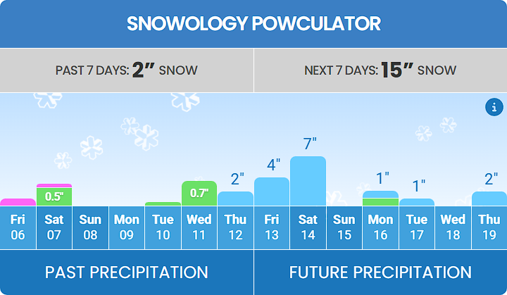
This is a good time to give a brief overview of how the Powculator works. This is the name for Snowology's precipitation calculator which is a part of very ski area's weather page which can be found through our Weather section. Non-subscribers however can only see the past precipitation and not the future.
I'll be using Stowe as an example to show how this works. This is what we call the "master" Powculator showing the past 7 days and future 7 days broken down by precipitation type.
Below the Powculator you will find the Ski Day Forecasts and by pressing on the down arrow next to each day it will expand to show what we call the "daily" Powculator broken down in 3-hour blocks as well as general hourly weather below that.
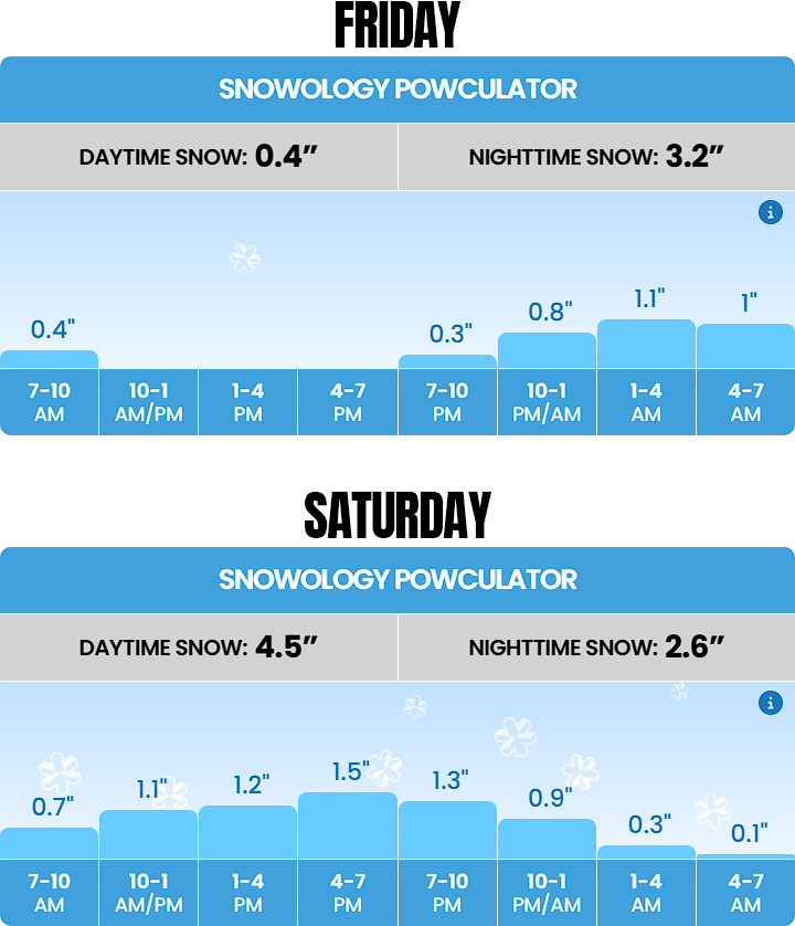
This gives you a good idea of when the snow will fall and how intense it will be. For instance there should be 3.2" on the ground by 7AM, and then an additional 4.5" will fall during the Saturday ski day with another 2.6" that falls after close that will refresh the surface for Sunday morning. These calculations are updated every 3 hours.
While the Powculator is currently fully automated, it has been tuned for various types of snow all the way down to individual ski areas. Starting next season we will be making manual adjustments down to the individual ski area on a daily basis and what is shown on our site will be our actual forecast that merges automation with manual adjustments.
I know that most of our subscribers joined when these written updates were all that we provided, but the Powculator is a huge step forward providing the detail that skiers and riders need to gauge what happens at their intended destination without having to pick through 1,000 words and graphics when they have already settled on a place to go. That's not to say that these articles aren't useful, they're in fact a great way to broaden your understanding and pick up on detail beyond just the weather like wind holds and surface conditions, all the way down to how to identify things like sticky snow. We'll automate more of this by next season also but we strongly believe overall that it is already the most accurate automated snowfall forecasting for East Coast ski areas.