

Stick a fork in summer and start the countdown because lift serviced skiing in the Northeast is likely only about 6 to 8 weeks away. Yes, it's really that close! Of course it hit 90F yesterday at our headquarters in Upstate New York and this heat wave should last about another week in the Northeast before we'll get a real taste of fall.
With summer over we can also look at the climate record and see how forecasts compared to results. The following graphic shows the NWS Climate Prediction Center's (CPC) forecasts for the summer issued in May, and then the actual results as computed by PRISM Climate Group compared to the climatological averages from the 1991-2020 period.
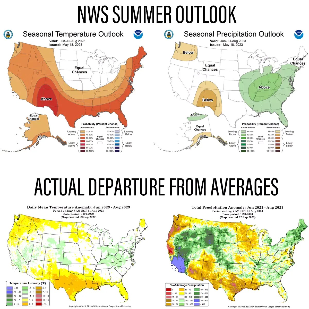
The CPC uses teleconnections and extended range modeling to generate these forecasts. Needless to say trying to predict temperatures and precipitation over a 3 month period is like trying to hit a moving target with a blindfold on. Skill will get you closer than a guess, but it's always going to be a mixture of hits and misses, and predictions for the first month generally perform better than the third month.
You can see the effects of Tropical Storm Hilary coming ashore in Southern California and while wasn't a hugely impactful event as far as severe weather goes, it impacted this area during the summer dry season and the clouds and precipitation from just this one event helped create a notable anomaly on precipitation and helped drag the average temperatures down. If you excluded that event the CPC likely would have been more on target in the West. That's a great example of how normal variability can have a bigger influence than larger scale patterns from teleconnections. This is also why you need to take all longer range outlooks with a grain of salt and keep in mind that a 50% chance of being warmer than average also typically means about a 30% chance of temperatures being near normal, and a 20% chance of temperatures being below normal. You can't judge probabilistic forecasts based on one forecast hitting or missing.
Climate Change Affects Lows More than Highs
In climatology mean temperatures are the primary reference point, but for winter enthusiasts and snowsports operations the lows matter more than the highs, and lows have been moving up faster than the highs have. This affects things like snowmaking by reducing production while running in more marginal temps and less opportunity to make snow due to less time below the necessary wet bulb temperatures. This is having a larger impact on when the season starts rather than when it ends in the Northeast since snowmaking can be adjusted to last longer, but not start earlier. This isn't a surprise unfortunately, rather it's expected as the result of well proven and pretty basic science.

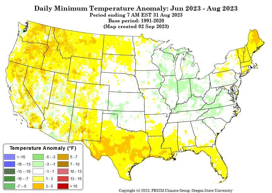
Highs in the Northeast trended cooler than average while lows were generally average to above average.
The heat from the Sun comes at us in different wavelengths than the heat released back from the water and ground. Greenhouse gases such as CO2 and CH4 (methane) do not capture the wavelengths that reach the Earth from the Sun, but the heat that is absorbed by water and land during the daytime is then released at night in the infrared spectrum and greenhouse gases absorb that heat nearer the surface and reflect some of it back. Less heat escapes the lower regions of the atmosphere as concentrations of those gasses increase. Our highs this summer were actually fairly cool, but our nights overall, especially in New England, were warmer than average. That is to be expected unfortunately.
You may notice the opposite effect in areas around Texas though. That heatwave happened under a dome of high pressure which helps to add to the daytime warming. Areas of high pressure have less clouds and that allows more of the Sun's energy to reach the surface during the day. At night those clear skies increase the radiative cooling though because water vapor is in fact a greenhouse gas. So the less water vapor in the air, the cooler the nights will be.
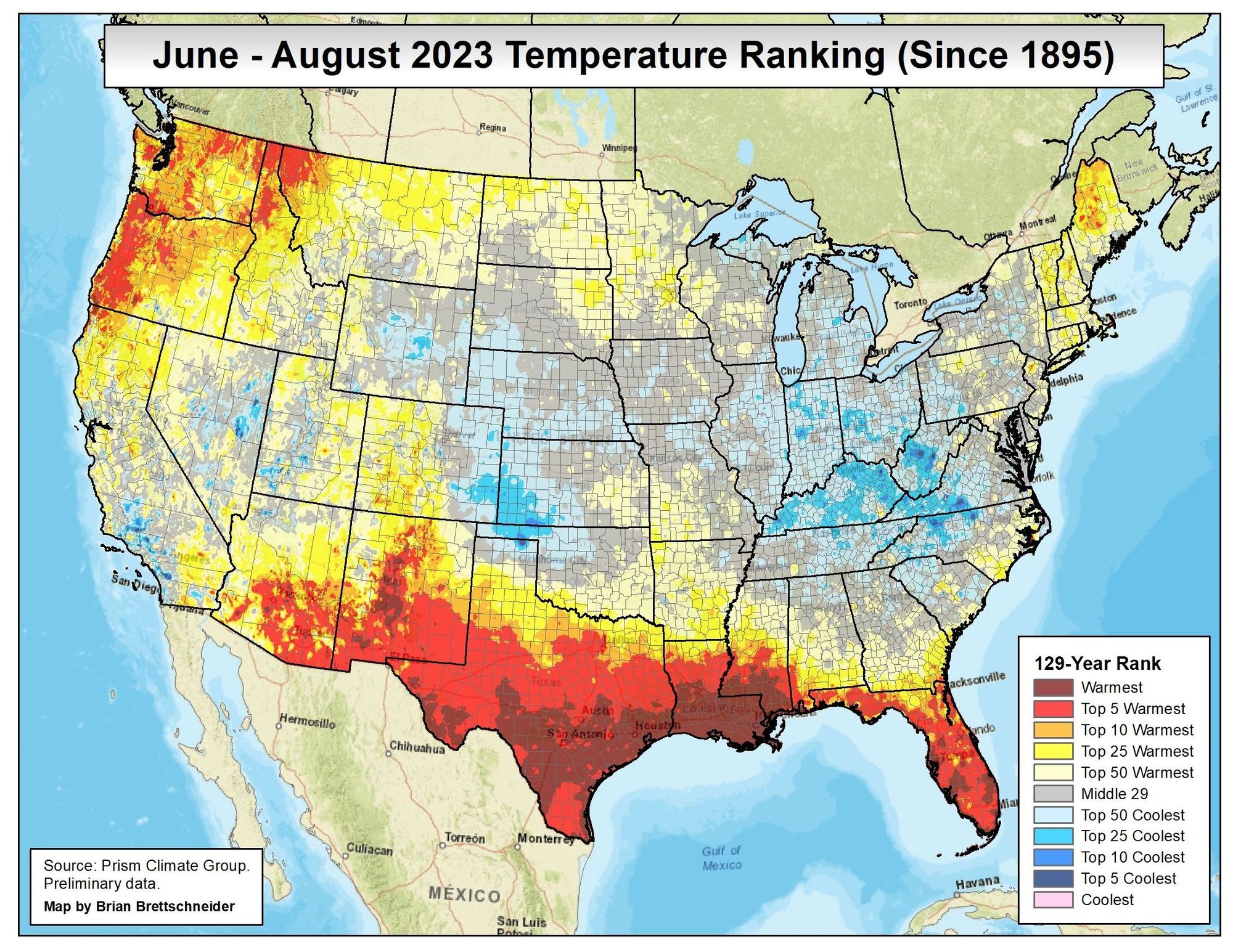
Temperature and Precipitation Rankings
Thanks to Climatologist Brian Brettschneider we have some more detailed maps based on the same data used by PRISM Climate Group, but this time with rankings based off of records going back to 1895. PRISM's maps have more smoothing than these do, but the added detail can create more noise from individual stations and as always mountainous areas have less accuracy because in many cases temperatures and precipitation are interpolated from nearby ground measurements.
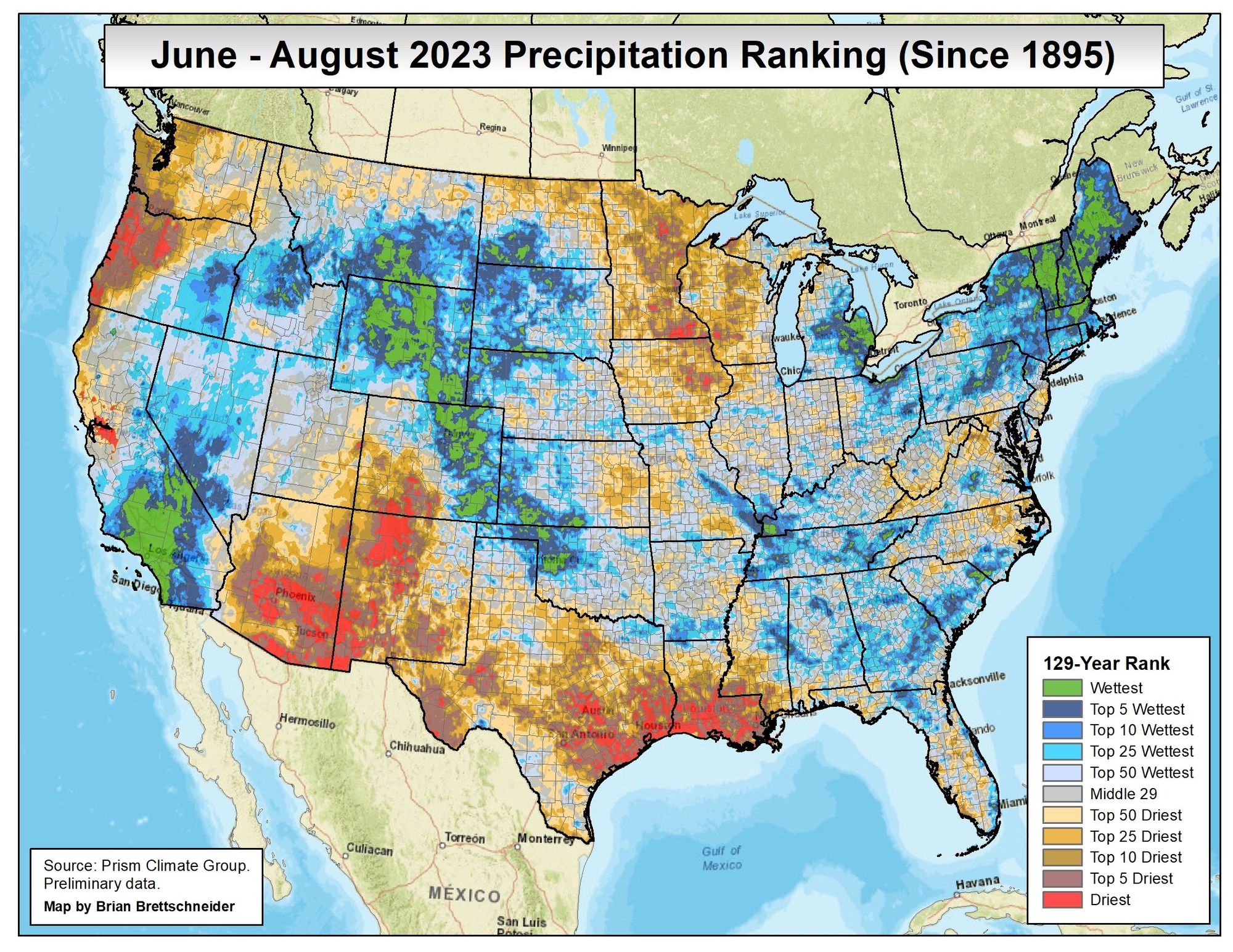
Is the rain over yet?
It was frickin wet in much of the Northeast this summer! Parts of NY, MA, VT, NH, and ME saw their record wettest summer, and this happened without any tropical systems impacting the Northeast. Fall is actually when most tropical systems form, and when the vast majority of such systems impact the Northeast. At least we don't have to worry about snowmaking ponds refilling, though even in dry years resorts seem to get that done just fine.
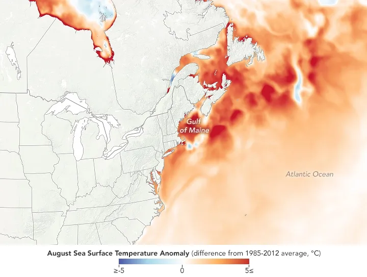
We also may be seeing the continuation of a long-term trend where warming has been more severe in Maine and the nearby seacoast than in other parts of the Northeast. This is largely due to the influence of warmer ocean waters in the Gulf of Maine, which is a shallow body of water on the continental shelf and lends itself to more rapid warming with climate change than deeper bodies of water. This is also combined with a slower Gulf Stream concentrating the warmer waters. The Gulf of Maine is unfortunately warming 7 times faster than the oceans on average. This is also impacted by a warming upstream air mass as the result of less snow cover and sea ice in arctic regions during the warmer months. Normal variability also of course applies as you cannot draw long-term conclusions on just 3 months of one year, but the trend for warming in this region is notable.
Summer Temperature Trends
We have another nifty map from Climatologist Brian Brettschneider showing how temperatures have changed during the summer months over the last 75 years. The West is rapidly warming during the summer which may be related to the mega drought with less clouds, while the East is warming less severely, but the Northeast more so than the Southeast for reasons described above.
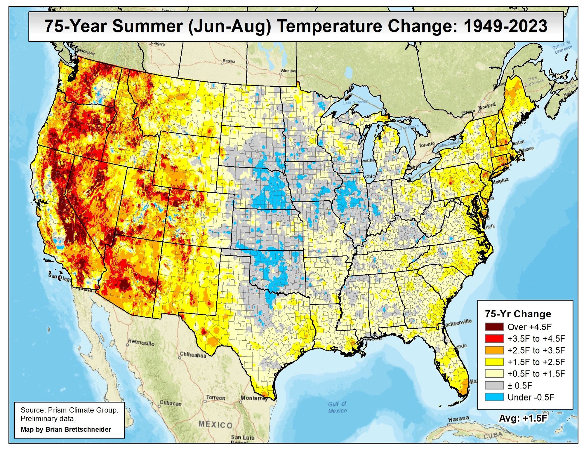
What's going on with the Midwest and Great Plains though? This is the result of modern agriculture with widespread irrigation in the breadbasket of the nation. We pump copious amounts of water from beneath the ground and spray it on crops where the process of evaporation actually draws heat from the air similar to those misters they use in desert climates to keep you cool. This may be the largest area of the globe where human activity has actually cooled the climate in some seasons, though the effects are more muted in the spring and fall, and absent in the winter. Overall they are seeing some warming on average also.


Comments ()