Here's this morning's NWS Snowfall Analysis along with a list of snow totals reported by ski areas this morning to SnoCountry. If you don't see your favorite ski area listed you can often look this information up from that ski area's own snow report.
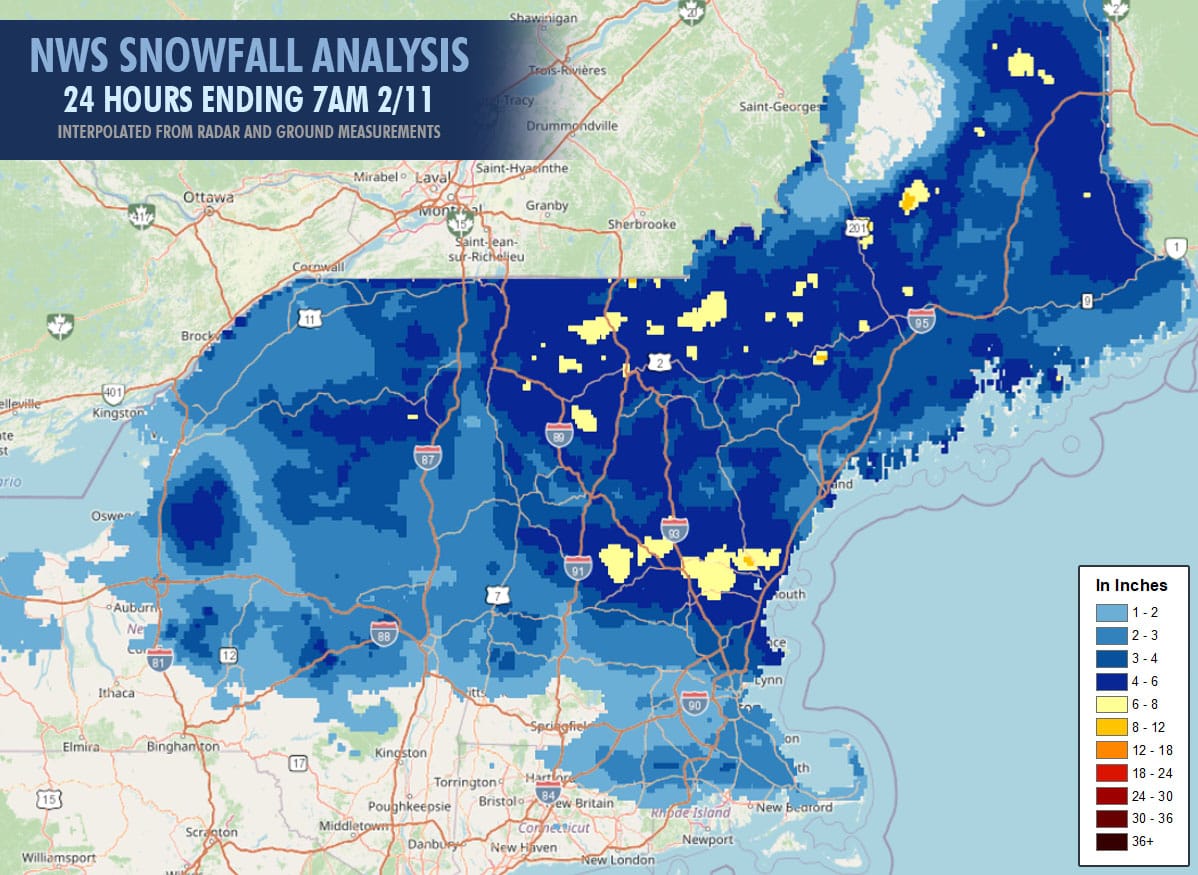
There was some unexpected enhancement on the southern edge that we pointed out last night on social media which did deliver an overperformance across parts of MA, S-VT, and S-NH. There was some underperformance mainly in isolated parts of N-VT where snow came in fine and dense on the first half of the storm though the back end still has about 24 hours to deliver the full depth and it is fluffy.
Here's a list of reports from this morning with a handful that updated shortly after opening. I have also included the Powculator estimates and highlighted the totals in red that were off by 2" or more.
| Ski Area | Reported | Powculator |
|---|---|---|
| Mad River Glen | 8" | 5.7" |
| Titus Mountain | 8" | 4.5" |
| Cannon Mountain | 6-8" | 4.2" |
| Bromont | 6" | 4.4" |
| Burke Mountain | 6" | 4.3" |
| Pats Peak | 6" | 3.0" |
| Sugarbush | 6" | 4.9" |
| Stowe Mountain | 6" | 6.1" |
| Crotched Mountain | 5" | 2.5" |
| Mont Orford | 5" | 3.2" |
| Smugglers' Notch | 5" | 6.6" |
| Whiteface Mountain | 5" | 4.0" |
| Jay Peak | 4-6" | 6.6" |
| Bolton Valley | 4-5" | 7.3" |
| Waterville Valley | 4-5" | 5.3" |
| Bromley Mountain | 4" | 3.9" |
| Cranmore Mountain | 4" | 4.4" |
| Jiminy Peak | 4" | 1.6" |
| Killington | 4" | 4.9" |
| Loon Mountain | 4" | 5.7" |
| Middlebury Snowbowl | 4" | 4.2" |
| Mount Snow | 4" | 2.4" |
| Okemo Mountain | 4" | 2.5" |
| Owl's Head | 4" | 3.4" |
| Saddleback Mountain | 4" | 4.6" |
| Stratton Mountain | 4" | 2.9" |
| Wildcat Mountain | 4" | 4.4" |
| Gunstock Mountain | 3-4" | 4.1" |
| Mont Sutton | 3-4" | 4.9" |
| Tenney Mountain | 3-4" | 4.8" |
| Berkshire East | 3" | 1.0" |
| Blue Hills | 3" | 2.3" |
| Bretton Woods | 3" | 3.0" |
| King Pine | 3" | 4.7" |
| Saskadena Six | 3" | 3.0" |
Ski area snow reporting doesn't always match our forecasting due to varying standards of measurement, both overreporting and underreporting, and also of course variability between the forecast and what actually falls. Overall our forecast largely confirmed expectations within 1" in most cases with some slightly higher and some slightly lower. The misses were primarily due to denser snow falling but not due to less moisture in the snowpack. Overreporting seemed to be minimal this morning.
Up to 6" is expected through Thursday morning on the back end of this storm with the highest totals expected in C-NY, around Titus, and Northern Vermont. Modeling has lightened the upsloping snow on the back end a little since yesterday however it is also coming in generally fluffier than expected so I feel things are probably on track overall.
Weekend Storm Potential
I would currently put the chances of a coastal storm bringing 6" to more than 10 ski areas at about 25%. A larger and stronger storm with widespread heavy snow has a probability of more like 10%.
Here's what the current deterministic versions of the GFS and ECMWF see for early Monday morning:
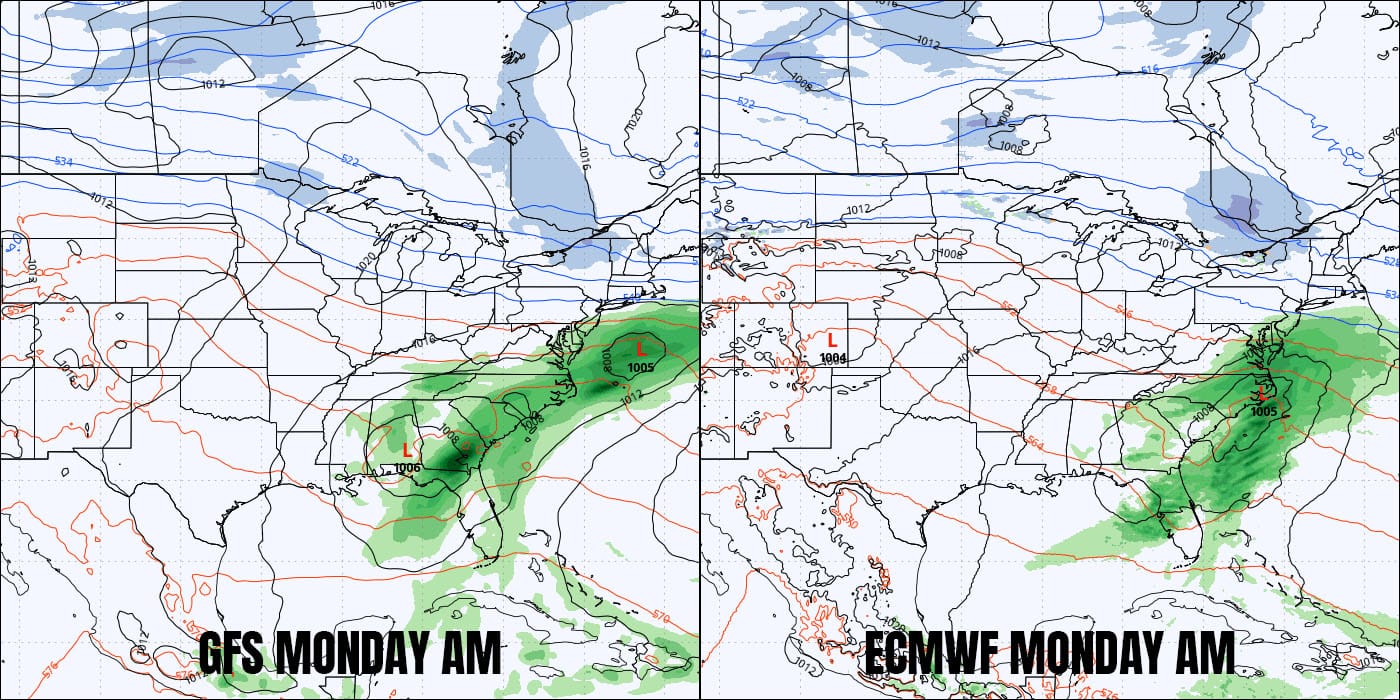
The GFS has been mostly steady signaling two low pressure centers and not interacting hardly at all with a small northern trough while the deterministic ECMWF only in the most recent run gave up on that connection and is now preferring an un-amped slide out to sea. Ensembles show minimal support for a coastal storm in line with the probabilities that I shared.
There will be a weak shortwave coming out of Canada on Saturday that should bring a nice refresh to mainly on the upslope in northern areas and then another one is possible on Monday though that looks weaker. Our next storm opportunity looks to be Wednesday and Thursday of the following week though chances are that it would not be all snow across the entire region, but getting more detailed at this range is a bit premature.
Knowledge Is Powder!
-- Matthew Scott


Comments ()