
This is a big day for Snowology.
After years of planning and 6 months of focused work from a group of 5 people, we have launched the first phase of our automated weather coverage for 183 ski areas in the East, stretching from Maine to Alabama and even including a handful in Quebec and Ontario. Most of our efforts have been focused on The Powculator which is the component of our system that estimates both past snowfall and future snowfall, and along with that with freezing r@!n and r@!n. Our forecasts will be free to the general public with the exception of future precipitation and all hourly weather data.
Our approach to automation is unique because of our focus on just ski areas in the East, and we can tune our automation by region, state, sub-region, and even by individual ski areas for optimal results. With 10 years of manual forecasting experience for just Northeast ski areas we already understand the model biases unique to the region and other weather forecasting challenges related to snow, precipitation types, wind holds, and more. On top of that we are ingesting over 25 million data points per day for just these ski areas in order to make this all happen.
We're going to step you through the new system but if you want to dive right in you can view it here:
Navigating Ski Areas
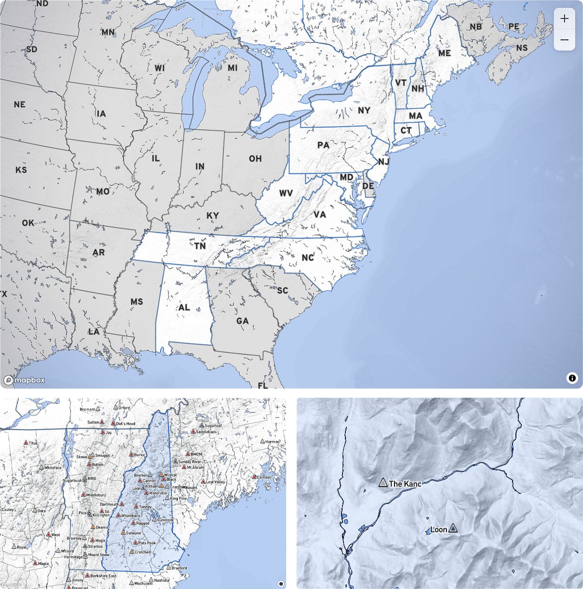
When you first reach this part of the site you will be presented with both a map for navigating and exploring, and a list of ski areas below that can be selected by state, region, and by major ski pass. As you zoom in ski areas will appear on the map based on their chairlift capacity which approximates their popularity, and our goal is to list every single ski area that is operating in the East. Clicking on a ski area in the map or in the list below the map will send you to the dedicated page for that ski area.
As this is just the first phase we do have more work to do here. We realize that our subscribers would like to save their Favorites and also sort lists of ski areas based on things like past snow, future snow, percentage of terrain open, and other things. These things will happen in the near future.
Understanding the "Weather Day"
Before we get into the weather automation details it is important first to understand that our forecasting follows something called the "Weather Day" which starts at 7AM and lasts for 24 hours. Many weather resources operate on this schedule in order to better differentiate low temperatures by grouping the entire night together, but in the case of ski areas it is also a great way to forecast how much snow will fall before open. If our forecast says 6" will fall on Tuesday, that includes snow that falls from 7AM Tuesday through 6:59AM on Wednesday morning.
The Powculator
Diving into the most important part of our system, this is front and center in the ski area weather view showing a combination of past snow and future snow.
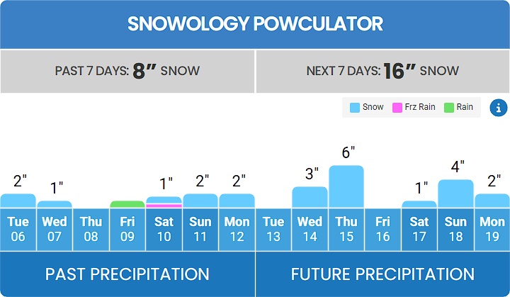
One of the biggest challenges that we have tried to tackle are huge discrepancies in snow reporting, including many who don't report at all. Also, without 10,000' mountains and marginal temperatures in winter we also need to build a record of r@!n and freezing r@!n for skiers and riders to help them navigate everything that will fall or has fallen. As a result we have decided that the best and most consistent method would simply provide our own estimates rather than trying to mix inconsistent and incomparable data in from ski area snow reporting.
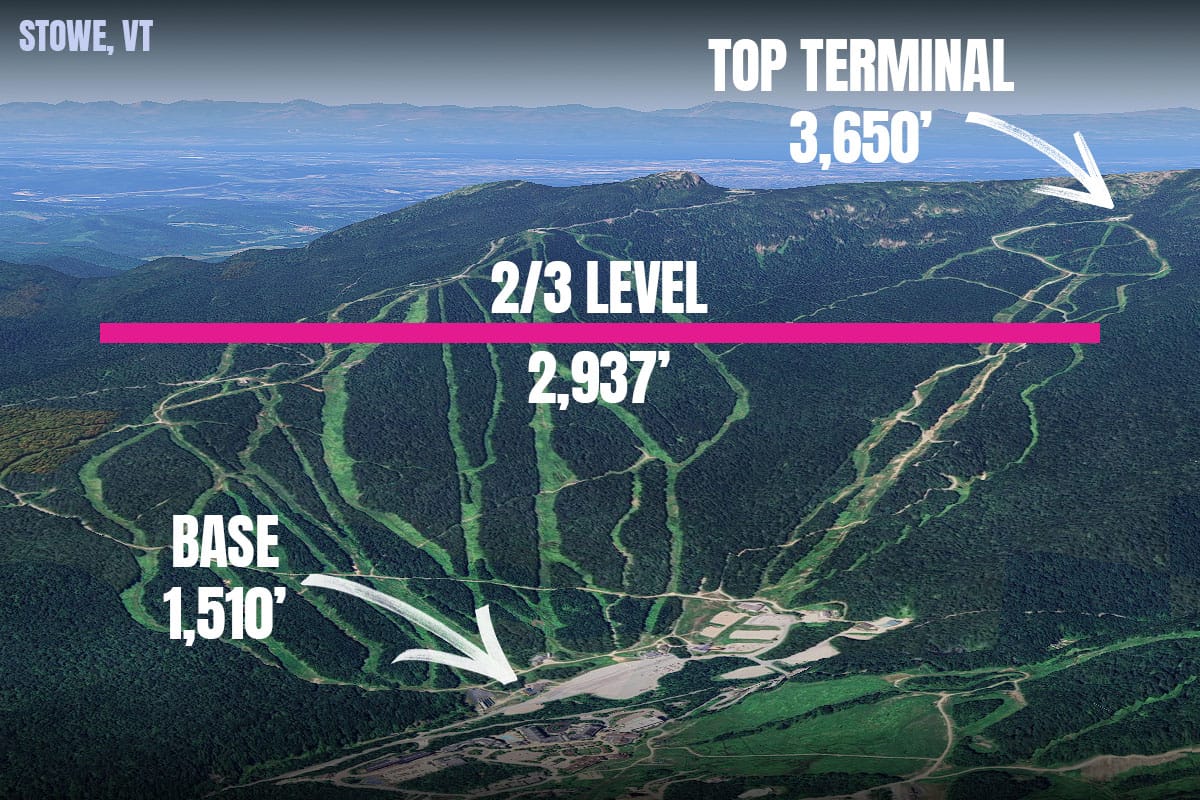
Our precipitation forecasting method is to target the 2/3 level of each ski area, measured from the main base to the highest lift terminal. This is essentially the 'Colorado Standard', and we're adopting it for the East (and we believe all ski areas should do the same). Snow does vary across mountains even at the same elevation, but our goal is to estimate the average amount of snow seen across this entire level of the mountain.
We've spent a great deal of time adjusting blends to correct biases, and we feel that about 75% of the universal biases have already been corrected. We are now just beginning the process of applying adjustments to individual ski areas and should have that initial work done shortly. Some mountains are in fact notably under-modeled, but we already know who they are and when this happens however at this time you may spot some of those standouts. We should have most of this handled by the following week.
When it comes to accuracy of future precipitation it is important to understand how our system works presently.
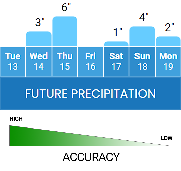
Days 1 & 2 will be highly accurate in most situations. Days 3 & 4 we start to see more model divergence and as a result our blends average down but there is generally good confidence that at least that much snow will fall. For days 5 through 7 we often see much more variability not just between models but also from run to run, and those totals will generally be pretty low. If you do see see bigger numbers at this distance that is a good sign of a potential incoming storm.
To date we have focused most of our attention on fine tuning the past snow and the first 2 days into the future. We will soon turn our attention to the medium and longer ranges in order to give a better impression of the potential snowfall that can be expected however this will also cause these numbers to shift frequently as new model runs come in.
Note that we are limiting our forecasts to 7 days because beyond that range in the East is essentially the "Fantasy Range". When you see a solid storm 7+ days out in the modeling there is better than a 50% chance of it not happening. We won't extend this range because we do not wish to mislead people or fill them with false hope. We understand that people make decisions to take time off from work, travel, and secure lodging based on the quality of our forecasts, and 7 days is the reasonable limit.
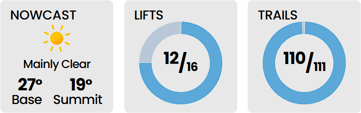
Nowcast & Operations
This section focused on the current weather and the number of lifts and trails that are open. Currently we are updating the Nowcast once an hour though we will eventually change this to every 15 minutes. For Lifts and Trails we are using data reported by ski areas to SnoCountry. In the event a ski area doesn't report to SnoCountry we will simply display the maximum number of lifts and trails. We attempt to detect the maximum number of lifts and trails open during a ski day rather than trying to keep this updated in real time.
Ski Day Forecasts
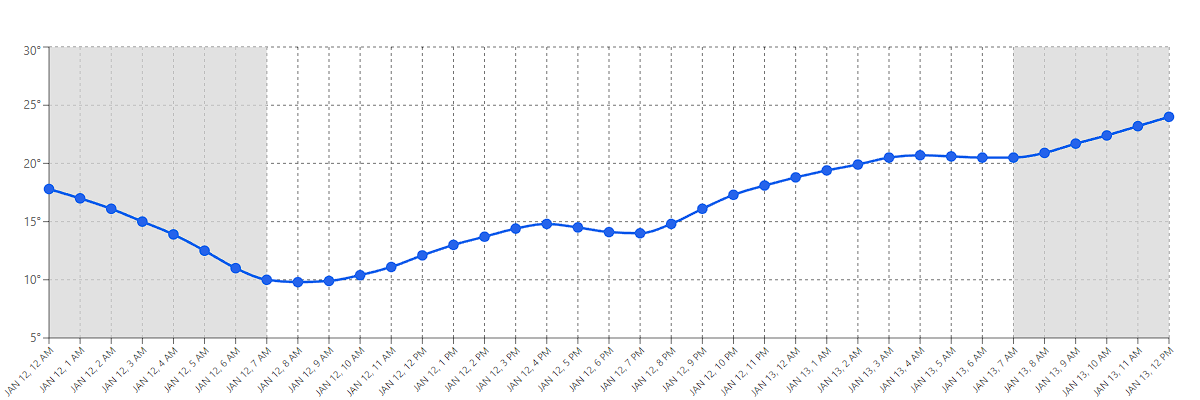
In this section you will find the temperatures, wind gusts, and conditions expected between 8AM and 4PM every day. We've labeled this as the "Ski Day" so that it is easy to identify the weather that you will find.
Our very next step in development of our weather automation is to allow subscribers to expand each day and view 24 hour graphs showing various weather elements related to precipitation, temperatures, wind, and other things that are useful to skiers and riders. We already have this data so it should be coming within a week or two; as soon as we design a nice interface for that data. We realize the hourly data is very important to our subscribers and that is why we are prioritizing it.
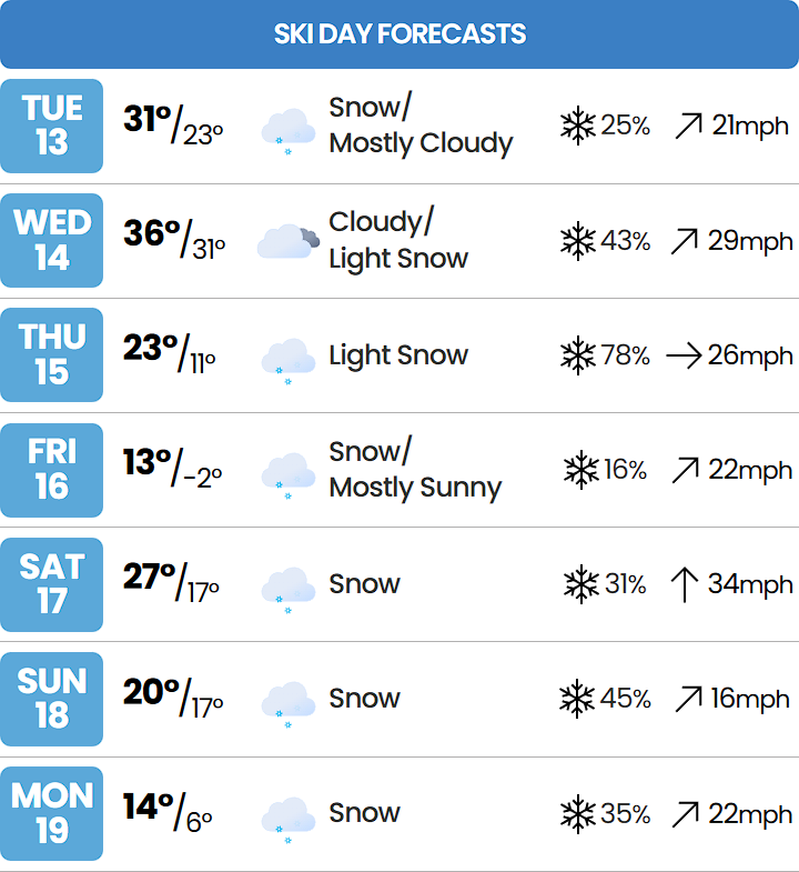
Note that we are likely to take out the precipitation probabilities as these are better suited to warm weather precipitation and instead we will begin to display alerts for things like wind hold potential, flash freezes, extremely cold weather, and other chief weather concerns that could impact your experience. Currently Canadian ski areas lack both the conditions and precipitation probabilities but we will address these shortly.
Much, Much More to Come
We've tried to provide everyone with an overview of not just what is there today but also of what is left to come in the near future. As this is our initial launch there are likely to find some bugs here and there, and we are still making adjustments to our automated forecasting many times a day, but our attention is going to rapidly change to focus on adding new features and capabilities to this system with many of those things on the top of our punch list mentioned above.
This will not replace our manual forecasting for the time being but when we feel it is ready we will merge both what is in the Weather section of our website with the data we display on maps in our articles. Before we do this we will have built a system to to make manual adjustments to our automated blends on a daily basis for a best of both worlds approach where the forecasts update every 3 hours with the latest model data and a real human making adjustments. We're confident that the end result will be much more accurate forecasts overall.
The next phase of Snowology is only just beginning!
Sköl!

Comments ()