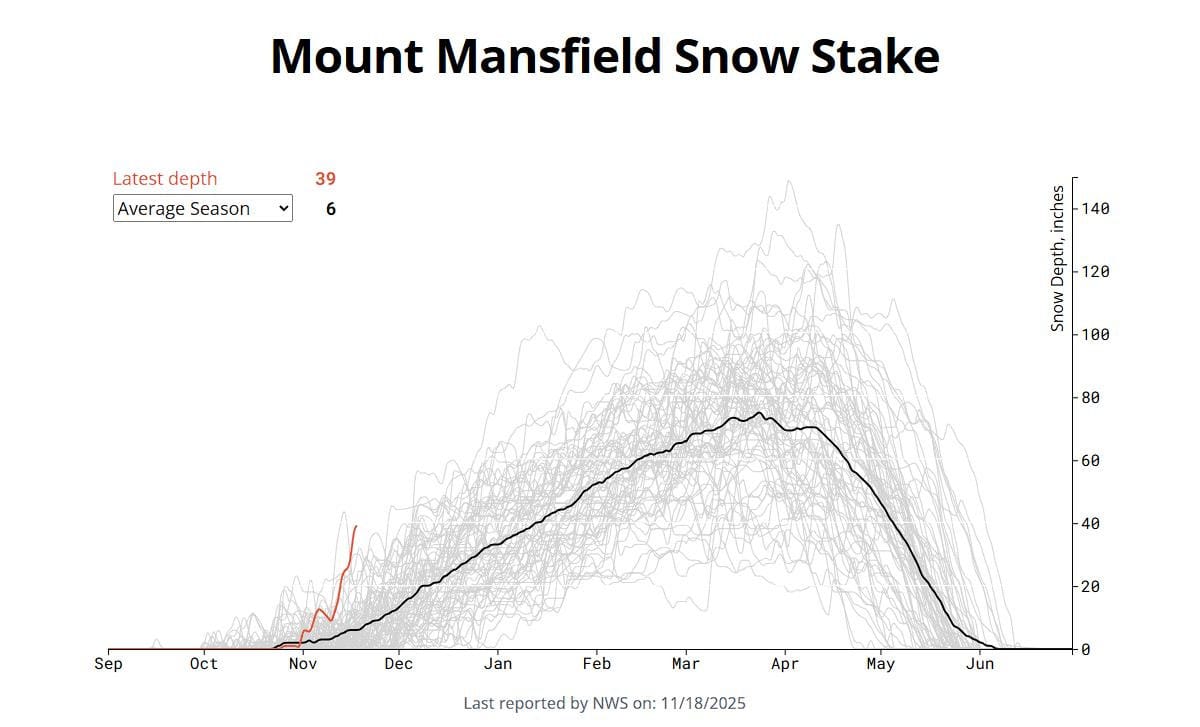
The cold weather came in slowly this season, but then, bam, November came with both snow and snowmaking temps. Last weekend we had 5 ski areas operating with Killington claiming a record amount of terrain on opening day, and the little mountain that could even joined the party. As soon as the weekend was over another great back end event with some lake effect and copious upsloping snow resulted in Titus Mountain opening on a 2 foot base of all natural for just one day on Wednesday, and the Mount Mansfield snow stake reached a record high for several days, topping out at 39", a full 550% above normal for that date.
Stowe and Jay Peak will offer substantial amounts of natural snow terrain on at least Friday, and there is potential of that at Sugarbush as well, while Killington has some but they are just churning out the snow and expanding terrain, and on Friday Sunday River will open Jordan with 2 full runs. Check those snow reports for details!
For this coming weekend we'll reach a minimum of 18 ski areas operating in the Northeast as of 2PM on Thursday 11/20. 13 of those 18 ski areas will also operating daily while 5 are opening just for this weekend before taking a break. This will be detailed for subscribers below. I've prepared an Operating Status Tracker covering just Saturday and Sunday, but note, there will be some openings on Friday as well and that will also be detailed for subscribers below.
We have updated to include 4 more ski areas that have announced opening today as well as one "maybe" as of 2PM. There could be more however we will not be updating this article again.
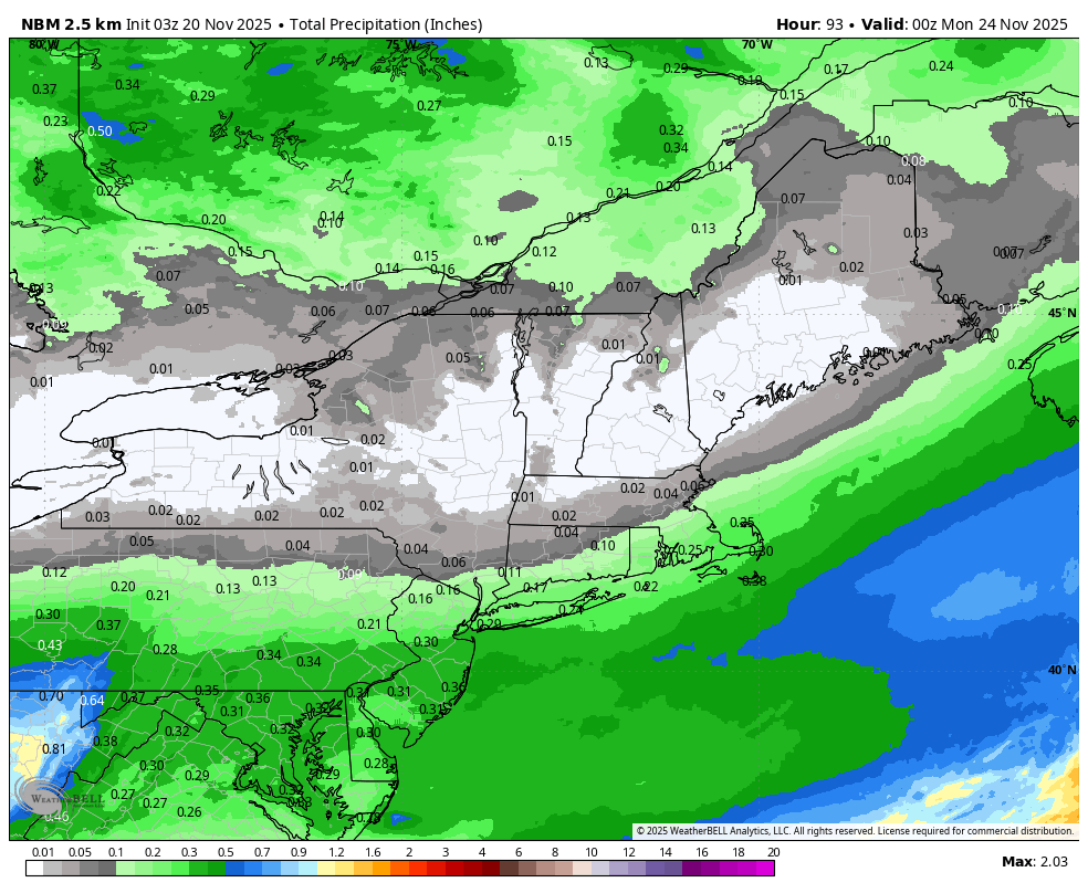
As far as weather goes there is only one day, Friday, out of the 3 days that could present some problems with light r@!n/snow, likely changing by elevation and temperatures as the day warms that are likely to cause natural snow to become sticky but this is unlikely to cause issues on manmade snow. Here's the precipitation expected this weekend, but note that the northern swath is likely to be all snow north of the St. Lawrence and an elevation mix into the northern parts of the Northeast.
I'll dive into this event in a little more detail for subscribers along with a temperature forecast for every resort operating for each of the 3 days. First though this is a great time to talk about our continuing development efforts on temperature forecasting automation.
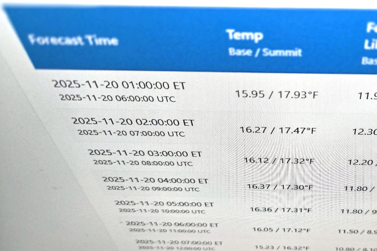
Precise Point Forecasting for Base and Summit Temperatures
Most automated weather sources only have a resolution of about 3,300' but our system is tuned to exact elevations. We can do this because we are approaching this differently than most automated forecasting by focusing on exact points corresponding to the base and summit of every ski area instead of trying to create forecast for every bit of land in the US and beyond. We manually collected location data for the base and the topmost lifts at 180 ski areas and then created our own model blend and adjustment algorithms to achieve this precise point resolution.
To be fair, there is no practical way that anyone could forecast these points perfectly at all times since mountains have microclimates and all models have shortcomings. For instance, weather models don't recognize when ski areas make snow on the mountains while otherwise the ground is bare, and this can have a notable impact on temperature forecasting accuracy until natural snowpack builds. We can however detect that situation and make the adjustments part of our algorithm, and eventually we will do just that!
We also have the ability to adjust our calculations down to one single point rather than making adjustments that affect everything like traditional forecasting automation, and some of our forecasting blends will also allow for manual adjustments by a forecaster from day to day. This is only possible because we are forecasting for points and not the whole map, and because our algorithms are entirely our own. This is unique to Snowology and this design has long been my vision.
We've been deep in development for many months, but we are near the point of releasing some of this work on our website, and in this update I will share temperature data from our our own systems for every operating ski area as a preview of what is to come.


