Meteorological Winter just started and just like that we received our first nor'easter and snowmaking is on full blast all over. This is without a doubt our best start of the season we have had since the epic November of 2018/2019. Let's hope it keeps going!
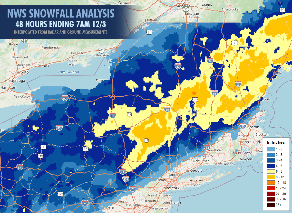
Though this last storm was only light to moderate in intensity it dropped a widespread swath of 6"-12" across the region with the highest reported total being Stratton who came in with a solid 12" of snow!
Here's a list of reports that we have collected from websites, social media, and SnoCountry:
Belleayre: 9"
Bretton Woods: 7"
Bromley: 9"
Burke: 7"
Camelback: 5"
Cannon: 8"
Cranmore: 10"
Gore: 5"
Hunter: 8"
Jay Peak: 3"
Killington: 7"
Loon: 7"
Mount Snow: 7"
Okemo: 7"
Stowe: 6"
Stratton: 12"
Sugarbush: 9"
Sugarloaf: 10" (base)
Sunday River: 10"
Wachusett: 9"
Waterville: 9"
Whiteface: 5"
Wildcat: 7"
My biggest forecasting misses were on the Longfellows of Maine, in some localized pockets in the Northern Greens where more snow fell than forecasted, and in Massachusetts and Southern New hampshire I was a little bit too high.
The cold air has been reinforced behind this system and snowguns are a blazin' all the way down to the Mid Atlantic with opening day announcements happening seemingly every hour lately. As of 8AM on Thursday we have 51 tracked ski areas who will be open this weekend, but note that Royal Mountain will be opening on Sunday, some of the ski areas that are opening for the season will actually start on Friday, and there are some other small ski areas also opening that we don't track on our maps.
We do expect some others to announce opening today and we will update this map in the web-based version of the article after 4PM and also share our Operating Status Tracker in our social feeds. We do share short-form updates regularly on these feeds rather than sending out a stream of emails to our subscribers, but we mix in the most important items like the Storm Postmortem above and our Operating Status Tracker in our articles.
As far as the weather this weekend goes, it's going to be rather quiet with only a weak cold front coming through on Saturday night and then Sunday night there's a shortwave coming through that has a slim chance of becoming a decent little snow event, but for now a weak wave and just some light snow is the leading solution. Here's the bird's eye view from the GFS covering Friday through Monday.
I'll cover the Weekend Weather Outlook in more detail for subscribers below, going over the precipitation, wind, and temperatures.


