I'm pretty confident right now that we'll see some ski areas receive over a foot of snow, maybe even double that... It goes without saying though that this storm will be boom or bust because we're also going to see many areas receive over 3" of rain and damaging winds.
Let's start with the broad view from the 12z run of the GFS from Friday through Monday.
We have now at the point where models see the low reaching the ocean right around NYC, and that's going to result in explosive growth of the storm, possibly a technical bomb in fact where the surface pressure drops over 24 mb in 24 hours. That's what happens when you swing a trough with an embedded shortwave all the way to the ocean.
Snowology is all about skiing and riding of course, but there will be some very negative effects from this storm, so pay attention to the official forecasts, especially in New England. There will be wind damage and flooding from this. The storm is a monster. That band that is feeding this storm stretches all the way to Mexico. It's an atmospheric river on par with some of the big ones they see in the West.
My first snowfall forecast map as well as discussions of wind and rain will be below the paywall for Premium Subscribers. For Sunday's wind and rain, please see this morning's Weekend Update because those maps are in there.

Where It Will Snow and How Much?
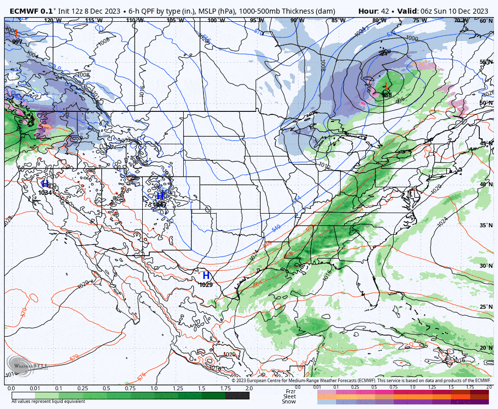
While we are pretty confident that Northern Vermont and the Eastern Townships will get a healthy dose of snow without a ton of rain preceding it, how much snow falls and exactly where else it falls is going to have much less confidence. What is happening is models are now seeing the boundary get close enough to the ocean for one of the lows embedded in that boundary to reach open water near NYC. When that happens, and It's probably 80% likely to happen, the storm is going to rapidly intensity, and that's what both the ECMWF and GFS see right now. Honestly, the GFS is kind of bonkers. An NWS friend even texted me this morning asking me if I saw it. It's sort of crazy, in fact I've never seen a storm do something like this. So let's show you that loop to start.
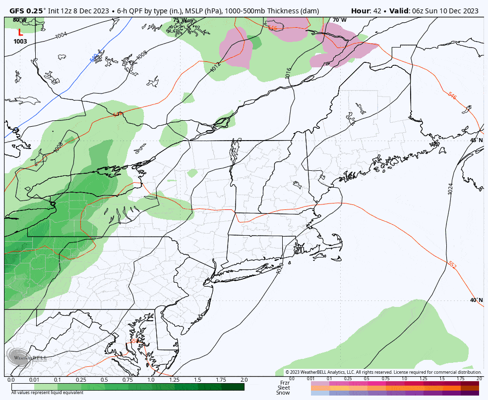
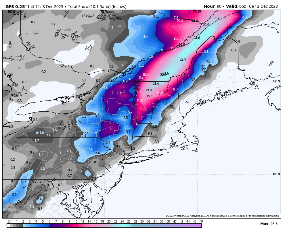
The low enters in the bottom corner at 1005 mb and exits the frame at 974 mb. That's a drop of 31 mb in less than 24 hours. Technically this matches the definition of a "bomb", or "bombogenesis". The ECMWF is weaker than the GFS, but models are still flapping from run to run, though now in the heavier range for snowfall. Here are the snowfall maps from the 12z runs of the GFS and ECMWF so that you can see what we are looking at.
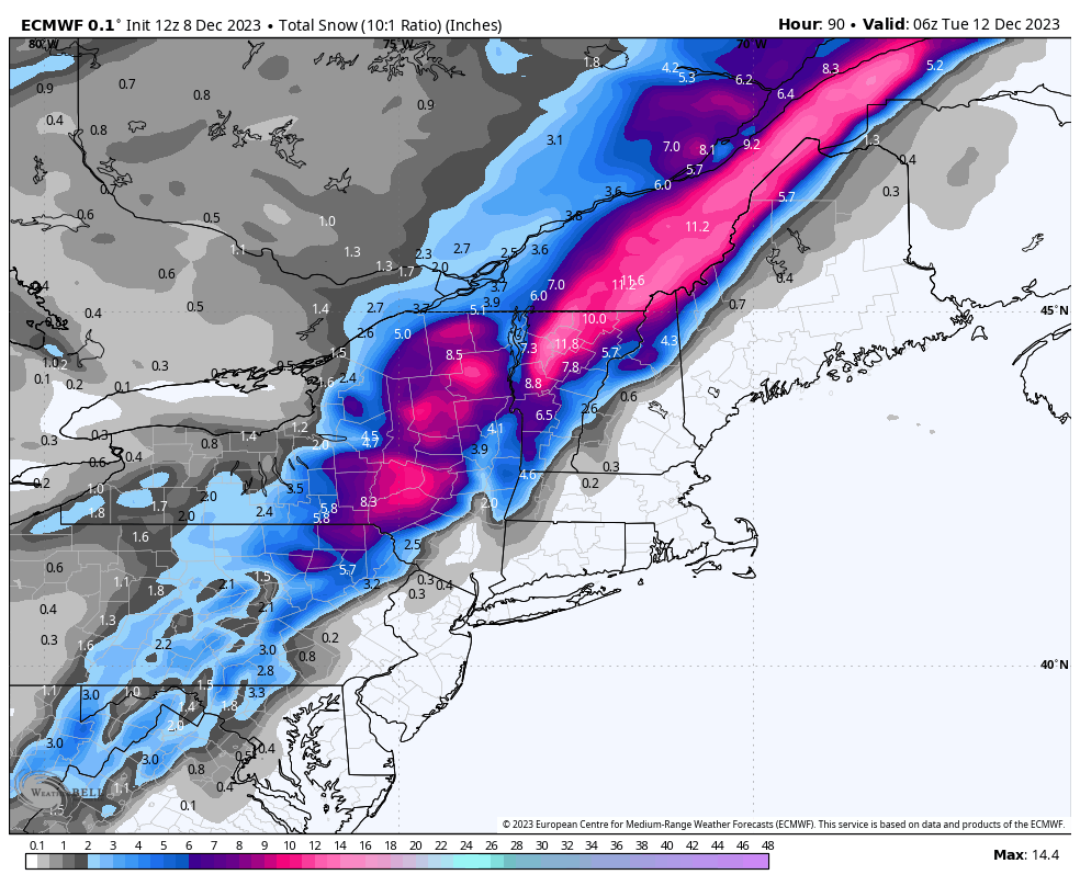
While there is pretty good confidence about the focus area, the edges are an open question, and clearly the amount of snow is also. It all depends on the strength of that low. So I'm definitely less confident about what happens in PA, as well as most of NY, especially the Catskills, and there are open questions in N-NH, and N-ME, though don't get your hopes up.
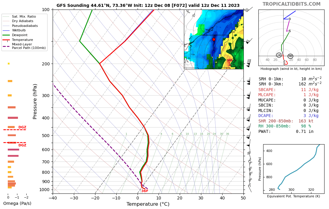
As far as snowfall ratios go, we're talking huge clumps of fat flakes falling at rates of over 3" per hour for part of this storm. Soundings show full saturation through the entire troposphere. I've honestly never see that before. That's what makes huge flakes, and the warm air near the ground is what will cause the flakes to clump together as they fall. It will be a wild sight for sure.
Which brings us to our first snowfall map for the storm. I'm being rightfully conservative at this time, especially considering that the snow should be very fluffy where it piles high, though this has a reasonably good chance of confirming. I would put the downside for the sweet spot not much further below what I'm forecasting, but you could add 50% to many of these totals if the storm does in fact bomb out starting near NYC. Keep in mind that everyone starts as rain in this storm, but not everyone flips to snow.
Most of the snow falls before close on Monday, but there's a good chance of enough snow falling after close to make Tuesday a powder day also. I will update the forecast once a day through Sunday. We will likely see some shifts.
Monday Wind Holds
Monday may be difficult at many ski areas due to wind, but with the storm bombing out and taking a more northeasterly path, wind issues in N-NY and N-VT seem minimal while elsewhere across the region we will have issues in the typical places. Many (not all) ski areas under the green in this map are at risk for wind holds on Monday. I'm afraid that Jay Peak isn't out of the woods, but the rest N-VT looks good right now. I'm going to wait until tomorrow for my first stab at the Monday wind holds. Things will change, but for now, green means caution and blue means a false sense of security.
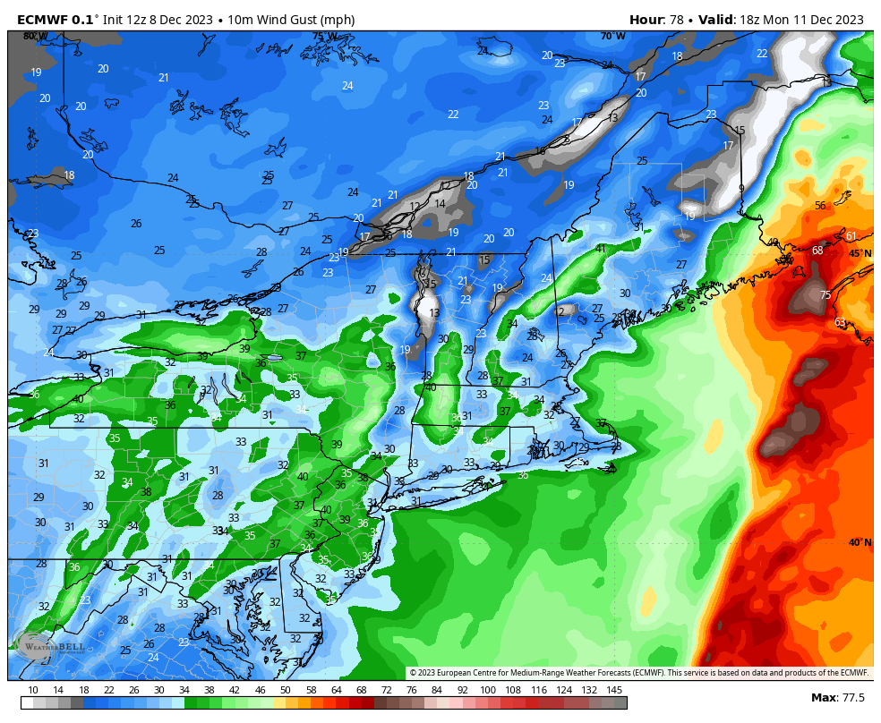
This isn't the full story on the wind either. Overnight from Sunday into Monday morning when the storm starts to bomb out, we are going to see hurricane force winds near the coast and also on the peaks. There will be problems in New England, and it will be more widespread than just your lawn furniture.
Oh, and the Rain...
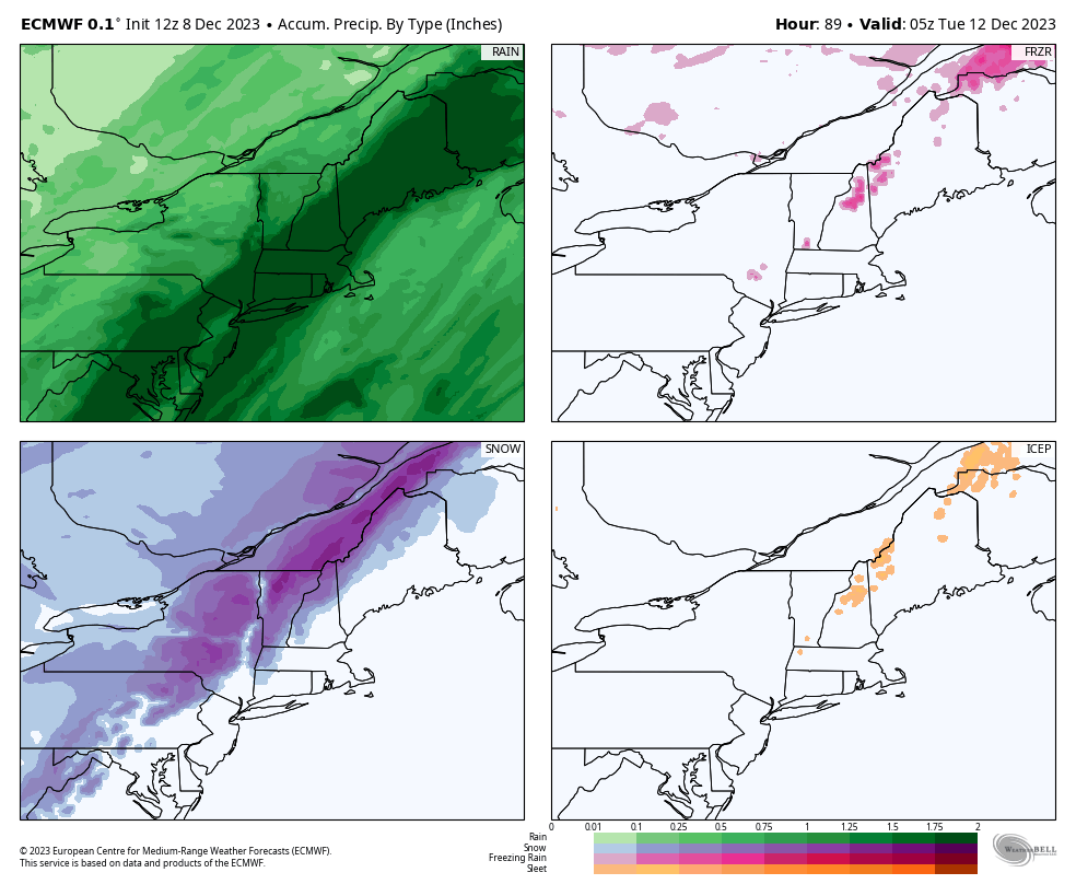
There is a broad swath of 2"-4" of rain that will stretch from E-PA through ME. This is going to cause significant damage to even snowmaking terrain at ski areas and possibly some flooding and runoff issues. I'm especially worried about Southern New England, NH, and ME. Let's start off with a precipitation by type, and I think you can spot where the rain quickly changes to snow, and where it doesn't.
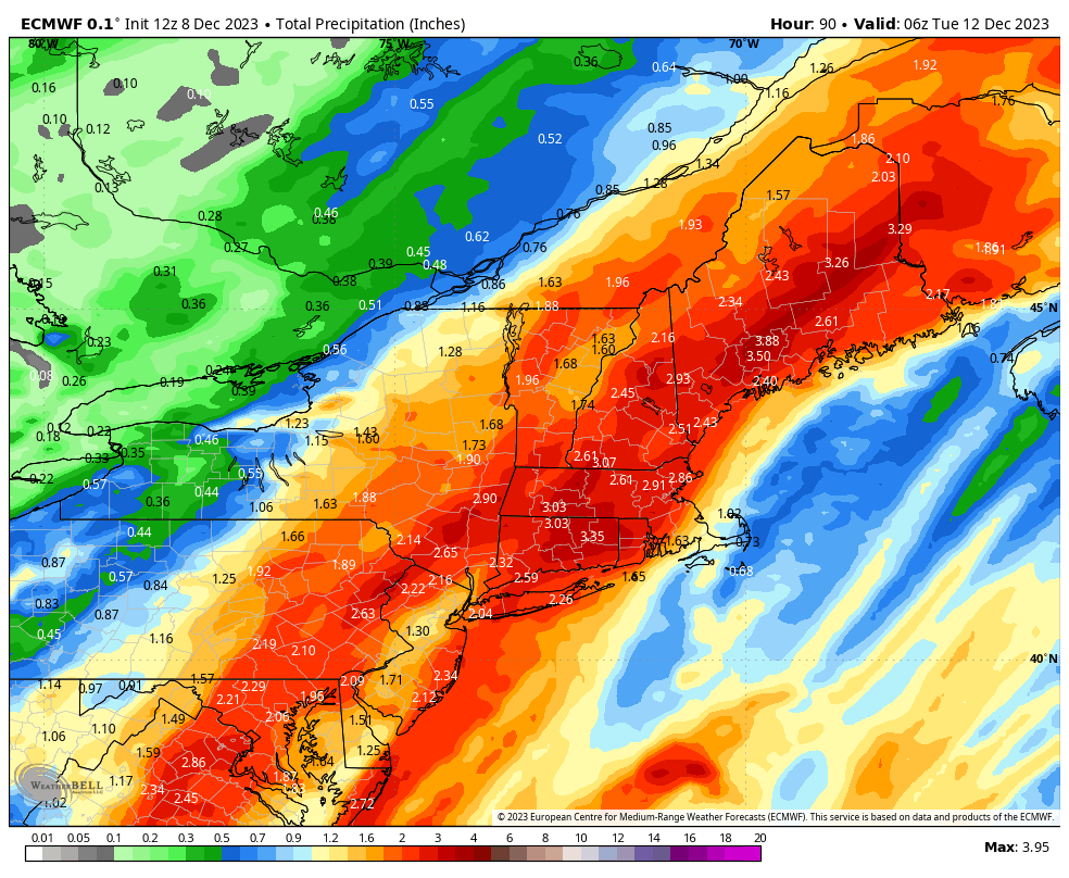
And here is the full ECMWF water map, but this shows the water from all forms of precipitation so keep in mind what the charts above say.
Knowledge is Powder!
-- Matt


Comments ()