I think I need to spend more time helping people understand that weather apps are virtually useless beyond 3 days when weather is active in the Northeast. Weather apps do not communicate the degree of confidence nor the trends in the forecast, and they certainly don't talk about snow conditions, or wind holds, or show you how to avoid the crowds since of course, "people are a condition". I do however, and that's why we're signing up hundreds of new subscribers per week!
Hey first guy, thanks for the shout-out and the positive attitude. Enjoy your packed pow! Hey second guy who laughed at the first guy, guess what 'bro', we're likely getting a snowstorm for at least part of the Northeast, and the first guy is going to know where it is likely to snow before the second guy will because the second guy isn't a subscriber and thinks weather apps are going to show him the way. It's probably not going to rain on Sunday in New England for at least most of the ski day...bro. There may be wind holds on both Sunday and Monday and for the life of me I can't find wind hold forecasts on weather.com or even at the NWS. That probably has something to do with wind holds not being "weather". Those resources also won't tell you about when the snow will get sticky, but I do, and that's why first guy is out skiing right now.
There's no better indication of a lack of knowledge about weather, conditions, and operations than some dude on the internet telling you that an app is just as good or that the information is free.
Let's take a look at a loop covering Friday through Monday from the 0z ECMWF.
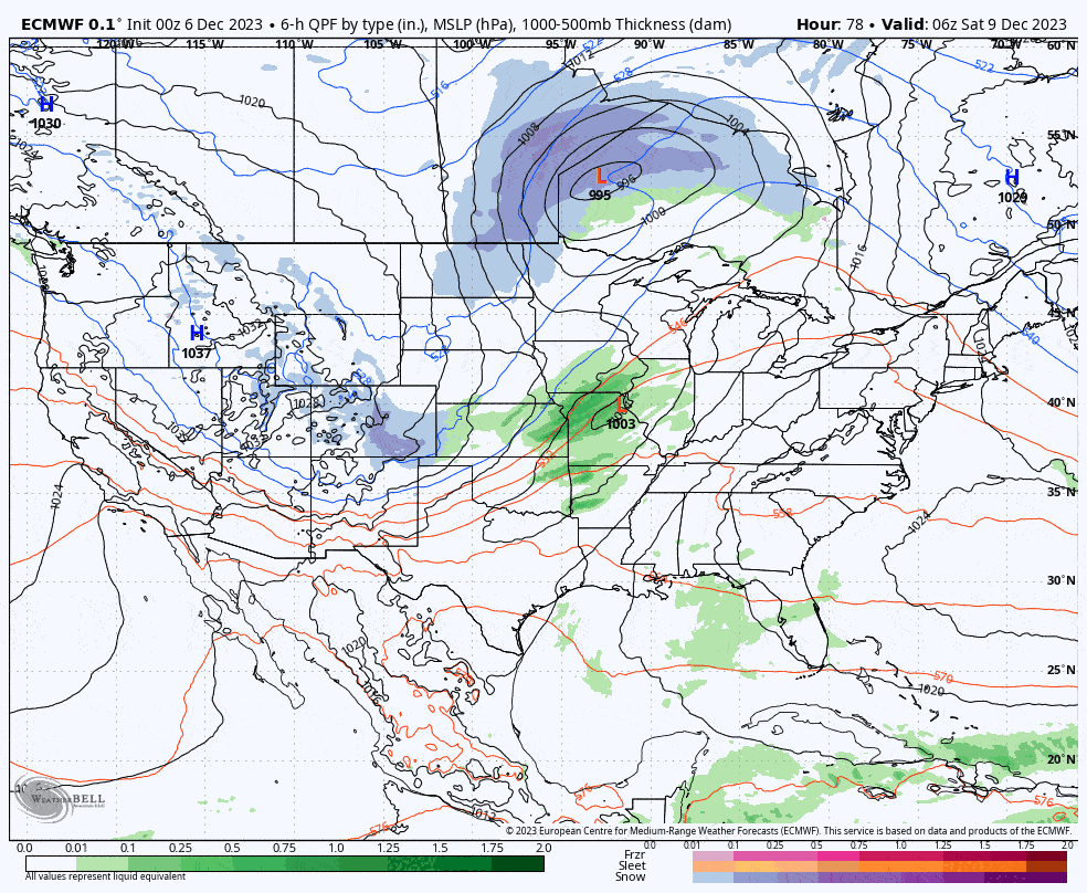
Yesterday I gave a 25% chance of a snowy solution for at least the western part of the Northeast, and today I'm giving that a 75% chance. Yesterday I also laid out 3 scenarios for how the models might be wrong despite almost zero support even in the ensembles yesterday, and scenario 1 and 3 combined to result in what all three major medium-range models are showing now just 24 hours later. They will shift some more and come into agreement over probably the next 48 hours. We're close to even having a true nor'easter, so that's a possibility still that can't be dismissed entirely just yet.

Now this storm still doesn't look good right now for most of New England even though parts of VT, N-NH, and N-ME might end as snow because there's a serious dousing of rain in front of that snow. This might improve for some and I'll dig into the storm more below the paywall for Premium Subscribers.
General Overview
As far as current modeling goes, instead of writing a bunch of stuff that would lose most people, I spent 2 hours putting together this animated GIF from the 0z GFS showing how there are now multiple storms with where they form and track.
That first storm is going to pull north too fast and the trough will continue digging into the Southeast where it will pick up warm moist air and with the help of the jet stream which is just in front of the trough, a new storm will form. None of the models had this yesterday, but they all show exactly this now.
My confidence still isn't strong in how exactly this develops and models are only in loose agreement on the major elements. The ECMWF is definitely over-amping so it's off in some ways, and the GEM sees a storm mature differently. This is normal for 4-5 days out of course. Where that second storm forms is absolutely critical, and possibly even that third low pressure center. Small adjustments in speed of various elements over 4-5 days can result in notable shifts in what falls from the sky.
And then there is this. We have a deep sharp trough reaching the Southeast and that trough is going to tilt negative (boom time for storms to form) in a sweet spot for nor'easters to be born, and the only reason why models don't see a nor'easter is because the storm forming along the low level jet early Sunday will be too close and strong. There's so much energy on this vorticity map and there's an outside shot that things could shift into nor'easter territory with just some minor changes in timing and location.
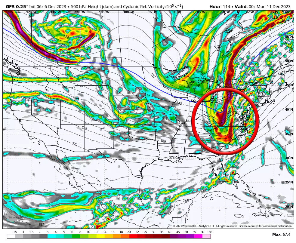
Do any of the ensemble members of the three major models see a nor'easter happening? Nope, not one, but there was maybe 5% support yesterday for what all three now count as their primary solution now so there's that. The ingredients are there is all, but the stars still have to align. I'll put the chances of a nor'easter running up the coast and through New England at about 20% right now. If a nor'easter does form, it would likely track pretty close to due north in this setup, so east of the Connecticut River is probably going to get skunked with mostly rain regardless, but west of the center it would dump over a foot of snow across a broad area.
Timing, Precipitation Types, and Wind
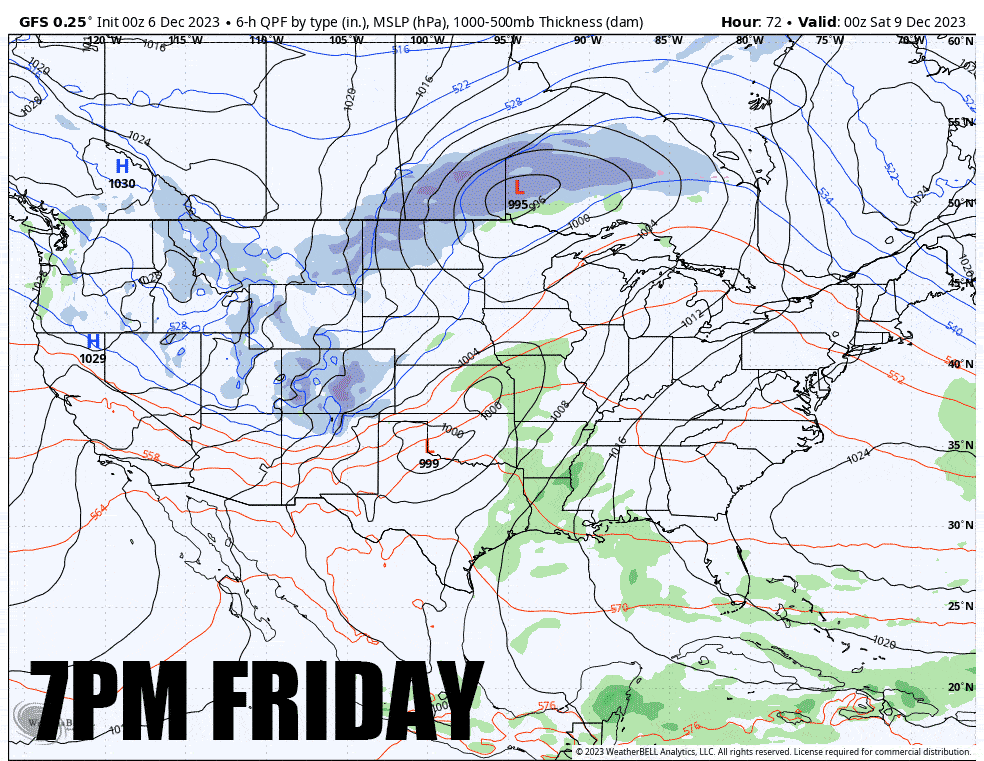
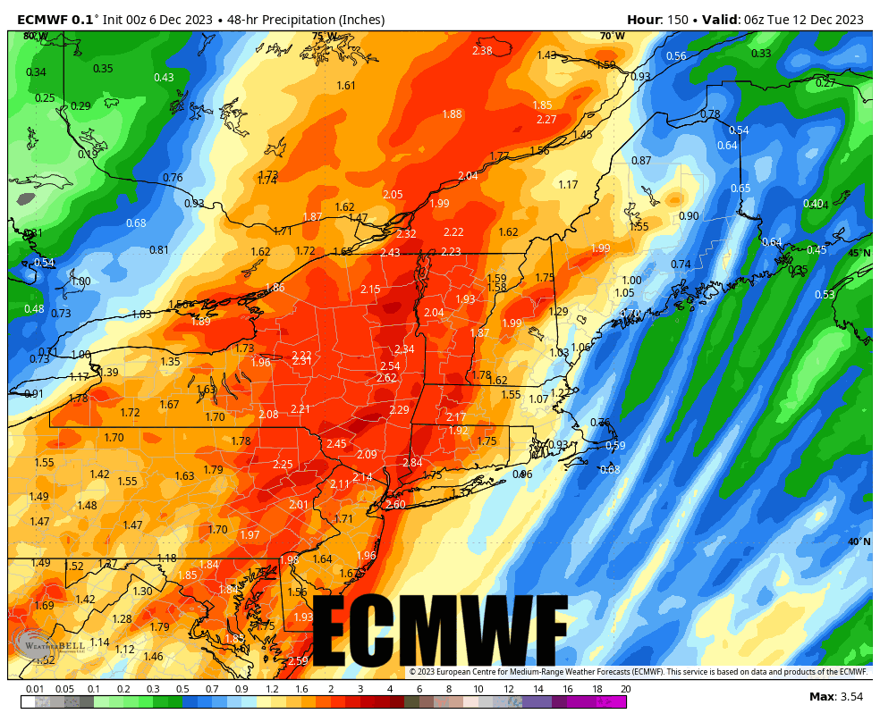
Right now it looks like light rain may reach just into CT, MA, and VT by close on Sunday. I wouldn't necessarily avoid planning Sunday as a ski day in New England just yet, though timing may change. In NY, NJ, and PA it looks like rain at least by noon-ish. This is what the 0z GFS shows for precipitation between 10AM-1PM on Sunday at present.

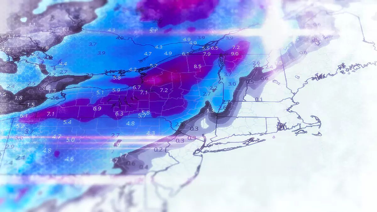
As far as precipitation types go, everyone will start off as rain while some will likely change to snow, and healthy snow totals look most likely in W-NY and C-NY, and the ADK's. The Catskills and N-VT are next on the list for a healthy changeover to snow mid-storm, but there will be more and more precipitation falling as rain as you move east. Here's what the three models at 0z see for snow from this storm.
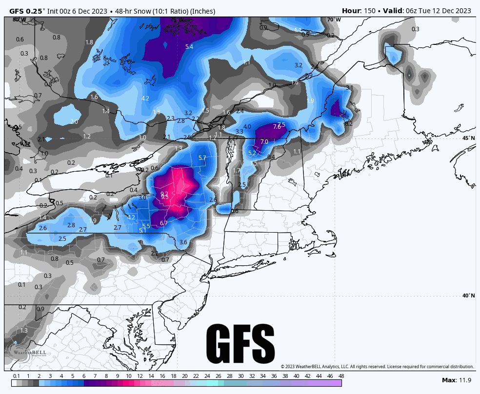
And now what the three models see for how much water will fall as both snow and rain, and most of this is likely to be rain, a lot of rain, way too much rain. Not good!
As far as wind goes, there will be strong southerlies associated with the low level jet, so right around when the heavy rain hits, you can expect wind holds. This likely affects some ski areas in PA, NY, and NJ, and possibly VT Sunday afternoon.
Behind the storm on Monday it appears that we will have a typical back-end wind event across the entire region. So if snow does fall Sunday into Monday, hunting that snow may be difficult. Wind hold and snowfall forecast maps for Sunday and Monday won't likely start to come out until Thursday and Friday.
Knowledge Is Powder, Bro!
-- Matt


Comments ()